Map Center of Natick topo map
Interactive topo map of Map Center of Natick, MA
| Place Name: | Map Center of Natick |
| Feature Class: | Topo Map |
| Country: | United States |
| Latitude: | 42.3125 |
| Longitude: | -71.375 |
| USGS Quad: | Natick topo map |
| 7.5´ topo: | 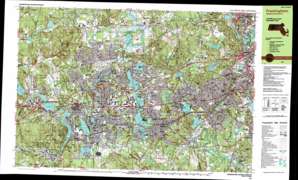 |
| State topo index: | MA topo index |
| Alternate map versions: | MA topographic maps Editions by year, direct download as GeoPDF. |
| 30´ x 60´ topo: | 1:100,000 scale map |
| 1° x 2° topo: | 1:250,000 scale map |
- Hunnewell Playground
- Butterworth Park
- Dennison Playground
- Bowditch Field
- Long Playground
- Interchange Twelve
- Interchange Thirteen
- Ashland Reservoir Dam
- Charles River Reservoir
- Cochrane Dam
- Sudbury River Reservoir
- Sudbury River Dam
- Mill Pond Dam
- Sudbury River Reservoir
- Charles River Reservoir
- Charles River Dam at South Natick
- Fisk Pond Dam
- Reservoir Number Two
- Reservoir Number 2 Dam
- Lake Waban Dam
- Reservoir Number 1 Dam
- Sudbury River Reservoir Number One
- Morses Pond Dam
- Foss Reservoir Dam
- Foss Reservoir
- Sudbury Dam
- Fiddlers Green Dam
- Sudbury River Reservoir
- Lake Cochituate Dam
- Charles River Reservoir
- Newton Lower Falls Dam
- Central Street Dam
- Packard Dam
- Cordingly Dam
- Charles River Reservoir
- Noruumberga Reservoir Dike Number 4
- Norumbega Reservoir Dikes Number 2
- Norumbega Reservoir Dikes Number 3
- Snake Brook Dam
- Dudley Pond Dam
- Norumbega Reservoir Dam and East Dike
- Schencks Pond
- Schencks Pond Dam
- Guinea Meadow
- Steep Brook
- Cold Spring Pond
- Reservoir Pond
- Guinea Meadow Swamp
- Overthrough Hill
- Steep Rock Hill
- Reservoir Hill
- Interchange Fifty One
- Interchange Fifteen
- Interchange Fifty
- Interchange Fourteen
- Interchange Forty Nine
- Interchange Fifty Four
- Interchange Fifty Three
- Auburndale Park
- Cochituate State Park
- Sudbury Reservoir
- Angelica Brook
- Baiting Brook
- Ballard Hill
- Banner Hill
- Gleason Pond
- Green Hill
- Grist Millpond
- Hager Pond
- Heard Pond
- Hop Brook
- Indian Brook
- Indian Head Hill
- Juniper Hill
- Lamb Hill
- Landham Brook
- Learned Pond
- Lokerville
- Magunco Hill
- Merriam Hill
- The Mountain
- Nobscot
- Nobscot Hill
- Norton Pond
- Pelham Island
- Pod Meadow
- Saxonville
- South Sudbury
- Sucker Pond
- Tippling Rock
- Tom Hill
- Mount Ward
- Wash Brook
- Waushakum Pond
- Mount Wayte
- West Natick
- Wildcat Hill
- Willow Brook
- Bare Hill
- Birch Meadow Brook
- Blanford Pond
- Brush Hill
- Carding Millpond
- Clark Hill
- Coburnville
- Cold Spring Brook
- Cowassock Brook
- Doeskin Hill
- Drury Hill
- Dudley Brook
- Eames Brook
- East Sudbury Station
- Farm Pond
- Fish Hill
- Framingham
- Framingham Center
- Gibbs Mountain
- Ashland Reservoir
- Emersons Cliff
- Babson Park
- Bogle Brook
- Broad Hill
- Carver Hill
- Cedarwood
- Charles River Station
- Charles River Village
- Cochituate
- Coolidge Hill
- Davis Brook
- Doublet Hill
- Dudley Pond
- Dug Pond
- East Natick
- Everett Hill
- Felchville
- Fuller Brook
- Hayward Brook
- Hundreds Woods
- Jennings Pond
- Lake Forest Park
- Longfellow Pond
- Camp Mary Day
- Maugus Hill
- Morses Pond
- Mud Pond
- Natick
- Natick Reservoir
- Newton Lower Falls
- Rockridge Pond
- Noanet Brook
- Nonesuch Pond
- North Hill
- North Natick
- Norumbega Reservoir
- Overbrook
- Patten Hill
- Pegan Hill
- Peirce Hill
- Peters Hill
- Pickerel Pond
- Pigeon Hill
- Pine Brook
- Pleasant Hill
- Reeves Hill
- Ridge Hill
- Sabrina Lake
- Seaverns Brook
- South Natick
- Stony Brook
- Tower Hill
- Train Hill
- Trout Brook
- Waban Brook
- Lake Waban
- Wayland
- Wellesley
- Wellesley Farms
- Wellesley Fells
- Wellesley Hills
- Weston
- Weston Reservoir
- Weston Station
- Wights Pond
- Bannister Brook
- Beaverdam Brook
- Lake Cochituate
- Cochituate Brook
- Course Brook
- Fisk Pond
- Snake Brook
- Grantville
- Ashland
- Framingham Reservoir Number One
- Framingham Reservoir Number Two
- Framingham Reservoir Number Three
- Mill Brook
- Morseville
- Old Wayland Reservoirs
- Sudbury Pond
- Paintshop Pond
- Abbotts Pond
- Rocky Ledge
- Boulder Brook
- Reeds Pond
- Mill Pond
- Eliot Hill
- Nob Hill
- Wellesley Post Office (historical)
- Charles River Post Office (historical)
- Wellesley Hills Post Office (historical)
- Digital Heliport
- United States Property and Fiscal Office Heliport
- Cochituate Heliport
- Natick Army Laboratories Heliport
- Wormid Airport
- Sudbury Airport
- Anna Murphy Playground
- Anniversary Park East
- Ashland Post Office
- Boy Scout Reservation
- Broadmoore Audubon Reservation
- Burbank Circle Playground
- Childrens Park
- Claxton Field
- Cochituate Post Office
- Concord Square Historic District
- Costanza Park
- Danforth Square Playground
- Fairbanks Road Playground
- Framingham Centre Common Historic District
- Frank G Feeley Park
- Irving Square Historic District
- Kelly Memorial Field
- Lanson Park
- Longs Playground
- Lower Falls Park
- Memorial Field
- Metropolitan Park
- Natick Center Historic District
- Reardon Park
- Richard Callahan State Park
- Simpson Park Playground
- Stone Park
- Sucker Pond Playground
- Sudbury Aqueduct Linear District
- Wellesley Hills Post Office
- Wellesley Post Office
- Winch Park Playground
- Woodfield Playground
- Boston Post Road Historic District
- Edwards Plain-Dowses Corner Historic District
- Hummewell Estates Historic District
- McIntosh Corner Historic District
- Old Town Bridge
- Sudbury Dam Historic District
- Wayland Center Historic District
- Wellington Farm Historic District
- Newton Lower Falls Historic District