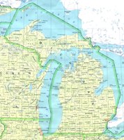
Michigan State Maps
Detailed maps of Michigan, printable MI maps online: Find detailed maps of Michigan, including online Michigan tourist maps, county maps, blank and outline maps.
Detailed maps of Michigan, printable MI maps online
Michigan
Population:
10,300,000 (8th in US)
Capital:
Lansing
Nickname:
Wolverine State
10 largest cities:
- Detroit, 920k
- Grand Rapids, 200k
- Warren, 140k
- Sterling Heights, 125k
- Flint, 115k
- Lansing, 119k
- Ann Arbor, 115k
- Livonia, 100k
- Dearborn, 95k
- Westland, 85k
Counties: 83
State Parks: 96


