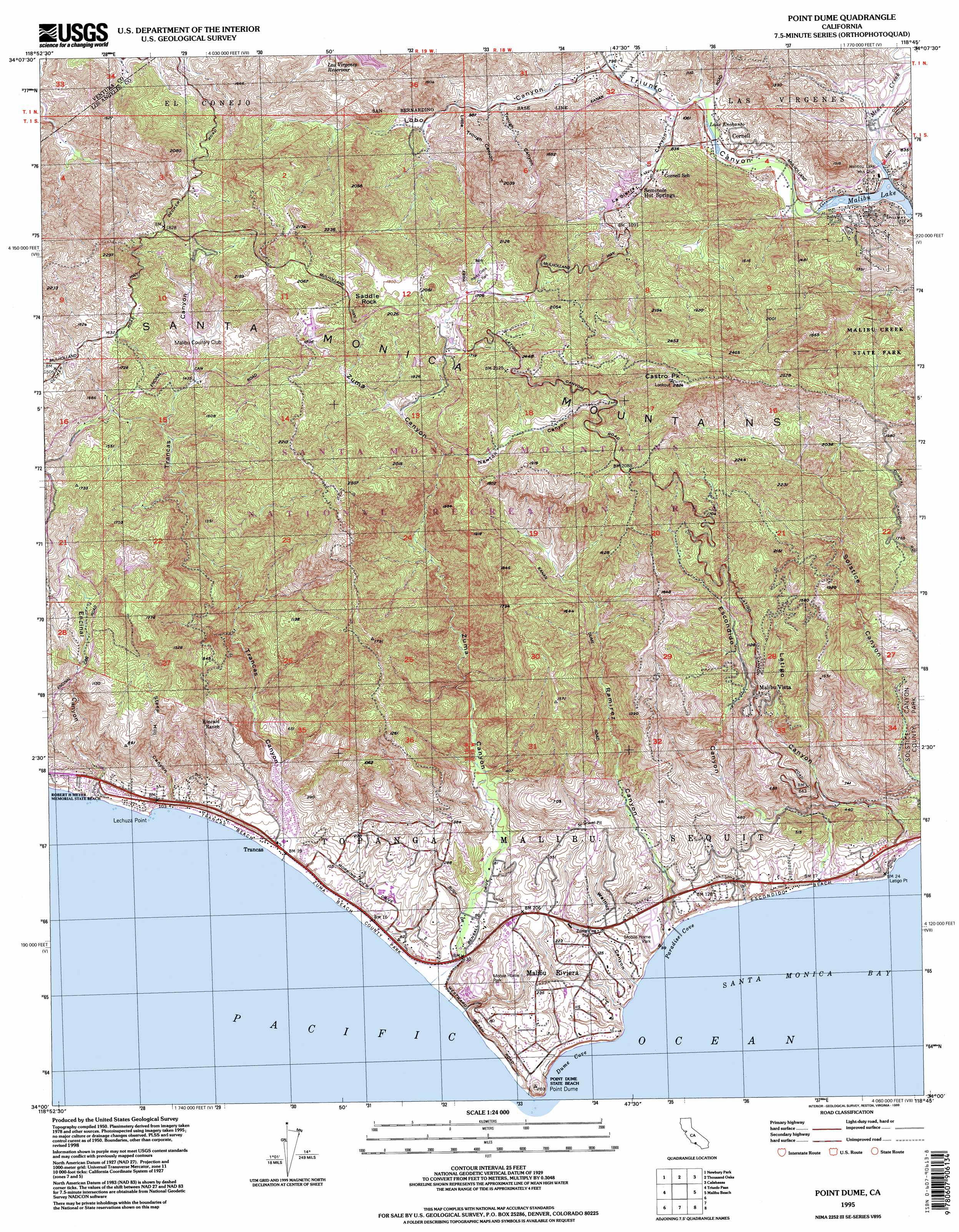
Point Dume Topo Map California
To zoom in, hover over the map of Point Dume
USGS Topo Quad 34118a7 - 1:24,000 scale
| Topo Map Name: | Point Dume |
| USGS Topo Quad ID: | 34118a7 |
| Print Size: | ca. 21 1/4" wide x 27" high |
| Southeast Coordinates: | 34° N latitude / 118.75° W longitude |
| Map Center Coordinates: | 34.0625° N latitude / 118.8125° W longitude |
| U.S. State: | CA |
| Filename: | o34118a7.jpg |
| Download Map JPG Image: | Point Dume topo map 1:24,000 scale |
| Map Type: | Topographic |
| Topo Series: | 7.5´ |
| Map Scale: | 1:24,000 |
| Source of Map Images: | United States Geological Survey (USGS) |
| Alternate Map Versions: |
Point Dume CA 1950, updated 1956 Download PDF Buy paper map Point Dume CA 1950, updated 1964 Download PDF Buy paper map Point Dume CA 1950, updated 1968 Download PDF Buy paper map Point Dume CA 1950, updated 1975 Download PDF Buy paper map Point Dume CA 1950, updated 1982 Download PDF Buy paper map Point Dume CA 1950, updated 1995 Download PDF Buy paper map Point Dume CA 1951 Download PDF Buy paper map Point Dume CA 1995, updated 1999 Download PDF Buy paper map Point Dume CA 2012 Download PDF Buy paper map Point Dume CA 2015 Download PDF Buy paper map |
1:24,000 Topo Quads surrounding Point Dume
Santa Paula |
Moorpark |
Simi Valley West |
Simi Valley East |
Oat Mountain |
Camarillo |
Newbury Park |
Thousand Oaks |
Calabasas |
Canoga Park |
Point Mugu |
Triunfo Pass |
Point Dume |
Malibu |
Topanga |
> Back to 34118a1 at 1:100,000 scale
> Back to 34118a1 at 1:250,000 scale
> Back to U.S. Topo Maps home
Point Dume topo map: Gazetteer
Point Dume: Airports
Anacapa View Estates Heliport elevation 165m 541′Los Angeles County Fire Department Heliport elevation 449m 1473′
Point Dume: Bays
Dume Cove elevation 0m 0′Paradise Cove elevation 0m 0′
Pirates Cove elevation 1m 3′
Point Dume: Beaches
Escondido Beach elevation 3m 9′Trancas Beach elevation 6m 19′
Westward Beach elevation 5m 16′
Point Dume: Capes
Lechuza Point elevation 2m 6′Point Dume: Dams
Malibou Lake Club 771 Dam elevation 221m 725′Point Dume: Parks
Malibu Equestrian Park elevation 31m 101′Point Dume State Beach elevation 7m 22′
Robert H Meyer Memorial State Beach elevation 34m 111′
Zuma Beach County Park elevation 2m 6′
Point Dume: Populated Places
Cornell elevation 240m 787′Mahou Riviera elevation 74m 242′
Malibu elevation 32m 104′
Malibu Mar Vista (historical) elevation 558m 1830′
Malibu Vista elevation 303m 994′
Malibu West elevation 16m 52′
Oak Hill elevation 373m 1223′
Paradise Cove Mobile Home Park elevation 34m 111′
Point Dume Mobile Home Park elevation 62m 203′
Seminole Hot Springs elevation 284m 931′
Seminole Springs Trailer Park elevation 282m 925′
Trancas elevation 5m 16′
Point Dume: Reservoirs
Lake Enchanto elevation 232m 761′Malibu Lake elevation 221m 725′
Point Dume: Streams
Medea Creek elevation 219m 718′Potrero Valley Creek elevation 243m 797′
Point Dume: Summits
Ballard Mountain elevation 619m 2030′Castro Peak elevation 855m 2805′
Point Dume elevation 56m 183′
Saddle Rock elevation 635m 2083′
Point Dume: Valleys
Encinal Canyon elevation 3m 9′Escondido Canyon elevation 5m 16′
La Sierra Canyon elevation 249m 816′
Latigo Canyon elevation 32m 104′
Little Trough Canyon elevation 265m 869′
Lobo Canyon elevation 244m 800′
Newton Canyon elevation 412m 1351′
Ramirez Canyon elevation 1m 3′
Steep Hill Canyon elevation 21m 68′
Trancas Canyon elevation 4m 13′
Trough Canyon elevation 261m 856′
Walnut Canyon elevation 0m 0′
Zuma Canyon elevation 4m 13′
Point Dume digital topo map on disk
Buy this Point Dume topo map showing relief, roads, GPS coordinates and other geographical features, as a high-resolution digital map file on DVD: