Maine topographic maps
These topographic index maps for Maine state are provided by the U.S. Geological Survey (USGS) for map sheet identification. To locate the USGS topo quad in Maine that you are trying to find, look at the index map of the appropriate map scale.
1:24,000 scale Maine topo quads
The index map below is for Maine topo quads at 1:24,000 scale. It is zoomable, and you can find the name of the 1:24,000 scale map (sometimes abbreviated as "24k") written diagonally across rectangular boxes that define the borders of the individual 24k map sheets.
Note that a rare few of the 1:24,000 scale (aka 7.5 minute) maps in Maine state might actually be at 1:25,000 scale, which is a very minor difference in map scale. Some of these 1:25,000 scale maps also cover a larger area than regular 7.5 minute maps. Those maps are 7.5´x15´ topo quads, and can be identified on the index map below by a larger sized rectangle that is twice as wide as usual (covers twice the longitude). The map names for these sheets are labelled horizontally, not diagonally.
Maine Topo Index Map: 1:24,000
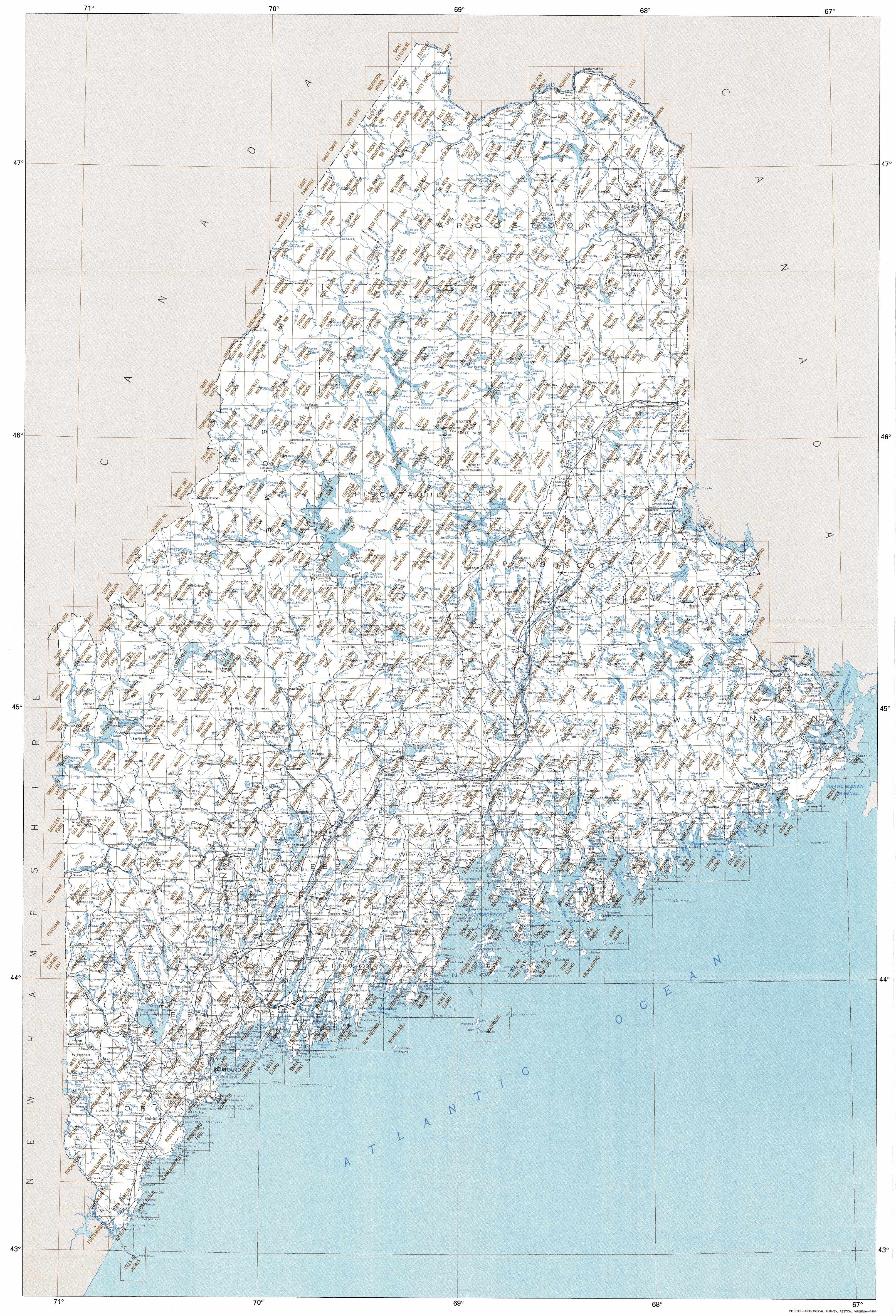
Hover over the index map to the left to view detailed zoom.
You can also download this index map here:
Maine topo index map at 1:24,000 Scale
24k ME topographic maps:
(This is a small selection to get you started. Use the complete list of 250k or 100k maps further below to drill down to your area of choice.)
47069d3 Saint Eleuthere, ME
47069d2 Estcourt, ME
47069d1 Landry, ME
47069c4 Morrison Brook, ME
47069c3 Rocky Brook, ME
47069c2 Hafey Pond, ME
47069c1 Beau Lake, ME
47068c5 Fort Kent North, ME
47068c4 Frenchville, ME
47068c3 Madawaska, ME
47068c2 Grand Isle, ME
47068c1 Lille, ME
47069b5 East Lake, ME
47069b4 Rocky Mountain Nw, ME
47069b3 Rocky Mountain, ME
47069b2 Johnson Brook Mountain, ME
47069b1 Falls Brook Lake, ME
47068b8 Saint Francis, ME
47068b7 Saint John, ME
47068b6 Wheelock, ME
1:250,000 scale Maine topo maps
Below you can find the 1:250,000 index map for Maine state. These topo maps give a general overview of an area and cover a large area: 1° latitude by 2° longitude. A list of all Maine topo map sheets at 250k follows on the right.
Maine Topo Index Map: 1:250,000

Hover over the index map to the left to view detailed zoom.
You can also download this index map here:
Maine topo index map at 1:250,000 Scale
250k ME topographic maps:
47068a1 Edmundston, ME
47066a1 Campbellton, ME
46070a1 Quebec, ME
46068a1 Presque Isle, ME
46066a1 Woodstock, ME
45070a1 Sherbrooke, ME
45068a1 Millinocket, ME
45066a1 Fredericton, ME
44070a1 Lewiston, ME
44068a1 Bangor, ME
44066a1 Eastport, ME
43608a1 Bath, ME
43070a1 Portland, ME
43068a1 Bath, ME
1:100,000 scale Maine topo maps
Below you can find the 1:100,000 index map for Maine state. These topo maps give a more detailed overview of an area and cover a medium-sized area: 0.5° latitude by 1° longitude. A list of all Maine topo map sheets at 100k follows on the right.
Maine Topo Index Map: 1:100,000
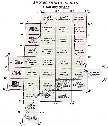
Hover over the index map to the left to view detailed zoom.
You can also download this index map here:
Maine topo index map at 1:100,000 Scale
100k ME topographic maps:
47069a1 Allagash, ME
47068a1 Madawaska, ME
47067a1 Van Buren, ME
46070e1 Montmagny, ME
46069e1 Clayton Lake, ME
46068e1 Presque Isle, ME
46067e1 Fort Fairfield, ME
46070a1 Lac Etchemin, ME
46069a1 Chamberlain Lake, ME
46068a1 Oakfield, ME
46067a1 Houlton, ME
45070e1 Megantic, ME
45069e1 Moosehead Lake, ME
45068e1 Millinocket, ME
45067e1 Danforth, ME
45071a1 Sherbrooke, ME
45070a1 Flagstaff Lake, ME
45069a1 Dover-Foxcroft, ME
45068a1 Lincoln, ME
45067a1 Calais, ME
44071e1 Groveton, ME
44070e1 Rumford, ME
44069e1 Skowhegan, ME
44068e1 Bangor, ME
44067e1 Machias, ME
44066e1 Eastport, ME
44071a1 Mount Washington, ME
44070a1 Lewiston, ME
44069a1 Augusta, ME
44068a1 Bar Harbor, ME
44067a1 Petit Manan Point, ME
43070e1 Portland, ME
43069e1 Bath, ME
43068e1 Matinicus, ME
43070a1 Kittery, ME
42070e1 Gloucester, ME