South Carolina topographic maps
These topographic index maps for South Carolina state are provided by the U.S. Geological Survey (USGS) for map sheet identification. To locate the USGS topo quad in South Carolina that you are trying to find, look at the index map of the appropriate map scale.
1:24,000 scale South Carolina topo quads
The index map below is for South Carolina topo quads at 1:24,000 scale. It is zoomable, and you can find the name of the 1:24,000 scale map (sometimes abbreviated as "24k") written diagonally across rectangular boxes that define the borders of the individual 24k map sheets.
Note that a rare few of the 1:24,000 scale (aka 7.5 minute) maps in South Carolina state might actually be at 1:25,000 scale, which is a very minor difference in map scale. Some of these 1:25,000 scale maps also cover a larger area than regular 7.5 minute maps. Those maps are 7.5´x15´ topo quads, and can be identified on the index map below by a larger sized rectangle that is twice as wide as usual (covers twice the longitude). The map names for these sheets are labelled horizontally, not diagonally.
South Carolina Topo Index Map: 1:24,000

Hover over the index map to the left to view detailed zoom.
You can also download this index map here:
South Carolina topo index map at 1:24,000 Scale
24k SC topographic maps:
(This is a small selection to get you started. Use the complete list of 250k or 100k maps further below to drill down to your area of choice.)
35082b3 Saluda, SC
35082b2 Landrum, SC
35082b1 Fingerville West, SC
35082a7 Eastatoe Gap, SC
35082a6 Table Rock, SC
35082a5 Cleveland, SC
35082a4 Slater, SC
35082a3 Tigerville, SC
35082a2 Campobello, SC
35082a1 Inman, SC
35081a8 Valley Falls, SC
35081a7 Cowpens, SC
35081a6 Gaffney, SC
35081a5 Blacksburg South, SC
35081a4 Kings Creek, SC
35081a3 Filbert, SC
35081a2 Clover, SC
35081a1 Lake Wylie, SC
35080a8 Fort Mill, SC
34083h1 Tamassee, SC
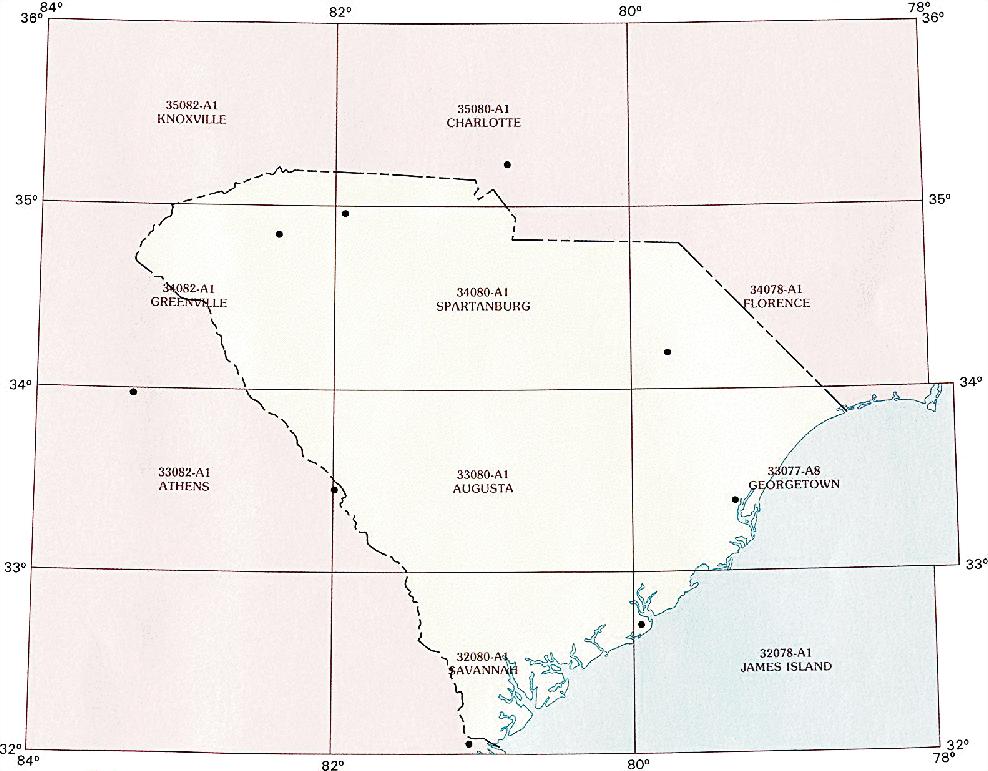
1:250,000 scale South Carolina topo maps
Below you can find the 1:250,000 index map for South Carolina state. These topo maps give a general overview of an area and cover a large area: 1° latitude by 2° longitude. A list of all South Carolina topo map sheets at 250k follows on the right.
South Carolina Topo Index Map: 1:250,000
Hover over the index map to the left to view detailed zoom.
You can also download this index map here:
South Carolina topo index map at 1:250,000 Scale
250k SC topographic maps:
35082a1 Knoxville, SC
35080a1 Charlotte, SC
34082a1 Greenville, SC
34080a1 Spartanburg, SC
34078a1 Florence, SC
33082a1 Athens, SC
33080a1 Augusta, SC
33078a1 Georgetown, SC
33076a1 East of Georgetown, SC
32080a1 Savannah, SC
32078a1 James Island, SC
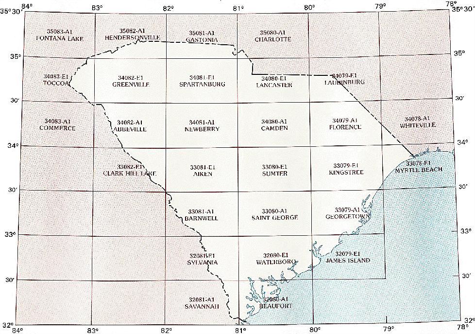
1:100,000 scale South Carolina topo maps
Below you can find the 1:100,000 index map for South Carolina state. These topo maps give a more detailed overview of an area and cover a medium-sized area: 0.5° latitude by 1° longitude. A list of all South Carolina topo map sheets at 100k follows on the right.
South Carolina Topo Index Map: 1:100,000
Hover over the index map to the left to view detailed zoom.
You can also download this index map here:
South Carolina topo index map at 1:100,000 Scale
100k SC topographic maps:
35083a1 Fontana Lake, SC
35082a1 Hendersonville, SC
35081a1 Gastonia, SC
35080a1 Charlotte, SC
34083e1 Toccoa, SC
34082e1 Greenville, SC
34081e1 Spartanburg, SC
34080e1 Lancaster, SC
34079e1 Laurinburg, SC
34083a1 Commerce, SC
34082a1 Abbeville, SC
34081a1 Newberry, SC
34080a1 Camden, SC
34079a1 Florence, SC
34078a1 Whiteville, SC
33082e1 Clark Hill Lake, SC
33081e1 Aiken, SC
33080e1 Sumter, SC
33079e1 Kingstree, SC
33078e1 Myrtle Beach, SC
33081a1 Barnwell, SC
33080a1 Saint George, SC
33079a1 Georgetown, SC
32081e1 Sylvania, SC
32080e1 Walterboro, SC
32079e1 James Island, SC
32081a1 Savannah, SC
32080a1 Beaufort, SC