Tennessee topographic maps
These topographic index maps for Tennessee state are provided by the U.S. Geological Survey (USGS) for map sheet identification. To locate the USGS topo quad in Tennessee that you are trying to find, look at the index map of the appropriate map scale.
1:24,000 scale Tennessee topo quads
The index map below is for Tennessee topo quads at 1:24,000 scale. It is zoomable, and you can find the name of the 1:24,000 scale map (sometimes abbreviated as "24k") written diagonally across rectangular boxes that define the borders of the individual 24k map sheets.
Note that a rare few of the 1:24,000 scale (aka 7.5 minute) maps in Tennessee state might actually be at 1:25,000 scale, which is a very minor difference in map scale. Some of these 1:25,000 scale maps also cover a larger area than regular 7.5 minute maps. Those maps are 7.5´x15´ topo quads, and can be identified on the index map below by a larger sized rectangle that is twice as wide as usual (covers twice the longitude). The map names for these sheets are labelled horizontally, not diagonally.
Tennessee Topo Index Map: 1:24,000

Hover over the index map to the left to view detailed zoom.
You can also download this index map here:
Tennessee topo index map at 1:24,000 Scale
24k TN topographic maps:
(This is a small selection to get you started. Use the complete list of 250k or 100k maps further below to drill down to your area of choice.)
36087e8 Tharpe, TN
36087e7 Bumpus Mills, TN
36087e6 Indian Mound, TN
36087e5 Woodlawn, TN
36087e4 New Providence, TN
36087e3 Clarksville, TN
36087e2 Sango, TN
36087e1 Adams, TN
36086e8 Springfield North, TN
36086e7 Youngville, TN
36086e6 Orlinda, TN
36086e5 Portland, TN
36086e4 Fountain Head, TN
36086e3 Turners Station, TN
36086e2 Westmoreland, TN
36086e1 Lafayette, TN
36085e8 Galen, TN
36085e7 Red Boiling Springs, TN
36085e6 Union Hill, TN
36085e5 Celina, TN
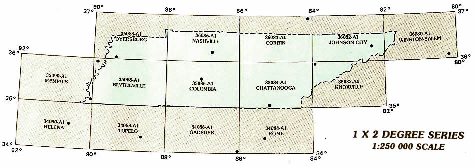
1:250,000 scale Tennessee topo maps
Below you can find the 1:250,000 index map for Tennessee state. These topo maps give a general overview of an area and cover a large area: 1° latitude by 2° longitude. A list of all Tennessee topo map sheets at 250k follows on the right.
Tennessee Topo Index Map: 1:250,000
Hover over the index map to the left to view detailed zoom.
You can also download this index map here:
Tennessee topo index map at 1:250,000 Scale
250k TN topographic maps:
36088a1 Dyersburg, TN
36086a1 Nashville, TN
36084a1 Corbin, TN
36082a1 Johnson City, TN
36080a1 Winston-Salem, TN
35090a1 Memphis, TN
35088a1 Blytheville, TN
35086a1 Columbia, TN
35084a1 Chattanooga, TN
35082a1 Knoxville, TN
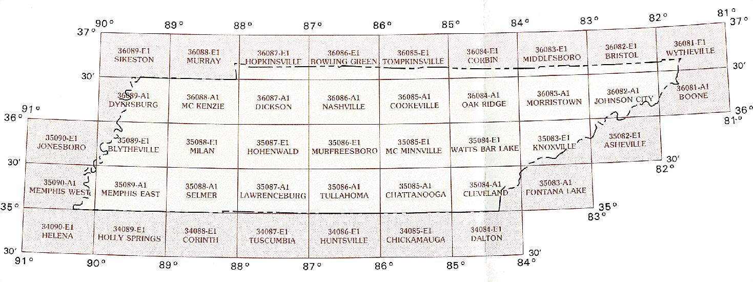
1:100,000 scale Tennessee topo maps
Below you can find the 1:100,000 index map for Tennessee state. These topo maps give a more detailed overview of an area and cover a medium-sized area: 0.5° latitude by 1° longitude. A list of all Tennessee topo map sheets at 100k follows on the right.
Tennessee Topo Index Map: 1:100,000
Hover over the index map to the left to view detailed zoom.
You can also download this index map here:
Tennessee topo index map at 1:100,000 Scale
100k TN topographic maps:
36089e1 Sikeston, TN
36088e1 Murray, TN
36087e1 Hopkinsville, TN
36086e1 Bowling Green, TN
36085e1 Tompkinsville, TN
36084e1 Corbin, TN
36083e1 Middlesboro, TN
36082e1 Bristol, TN
36081e1 Wytheville, TN
36089a1 Dyersburg, TN
36088a1 Mc Kenzie, TN
36087a1 Dickson, TN
36086a1 Nashville, TN
36085a1 Cookeville, TN
36084a1 Oak Ridge, TN
36083a1 Morristown, TN
36082a1 Johnson City, TN
36081a1 Boone, TN
35090e1 Jonesboro, TN
35089e1 Blytheville, TN
35088e1 Milan, TN
35087e1 Hohenwald, TN
35086e1 Murfreesboro, TN
35085e1 Mc Minnville, TN
35084e1 Watts Bar Lake, TN
35083e1 Knoxville, TN
35082e1 Asheville, TN
35090a1 Memphis West, TN
35089a1 Memphis East, TN
35088a1 Selmer, TN
35087a1 Lawrenceburg, TN
35086a1 Tullahoma, TN
35085a1 Chattanooga, TN
35084a1 Cleveland, TN
35083a1 Fontana Lake, TN
34090e1 Helena, TN
34089e1 Holly Springs, TN
34088e1 Corinth, TN
34087e1 Tuscumbia, TN
34086e1 Huntsville, TN
34085e1 Chickamauga, TN
34084e1 Dalton, TN