Colorado topographic maps
These topographic index maps for Colorado state are provided by the U.S. Geological Survey (USGS) for map sheet identification. To locate the USGS topo quad in Colorado that you are trying to find, look at the index map of the appropriate map scale.
1:24,000 scale Colorado topo quads
The index map below is for Colorado topo quads at 1:24,000 scale. It is zoomable, and you can find the name of the 1:24,000 scale map (sometimes abbreviated as "24k") written diagonally across rectangular boxes that define the borders of the individual 24k map sheets.
Note that a rare few of the 1:24,000 scale (aka 7.5 minute) maps in Colorado state might actually be at 1:25,000 scale, which is a very minor difference in map scale. Some of these 1:25,000 scale maps also cover a larger area than regular 7.5 minute maps. Those maps are 7.5´x15´ topo quads, and can be identified on the index map below by a larger sized rectangle that is twice as wide as usual (covers twice the longitude). The map names for these sheets are labelled horizontally, not diagonally.
Colorado Topo Index Map: 1:24,000
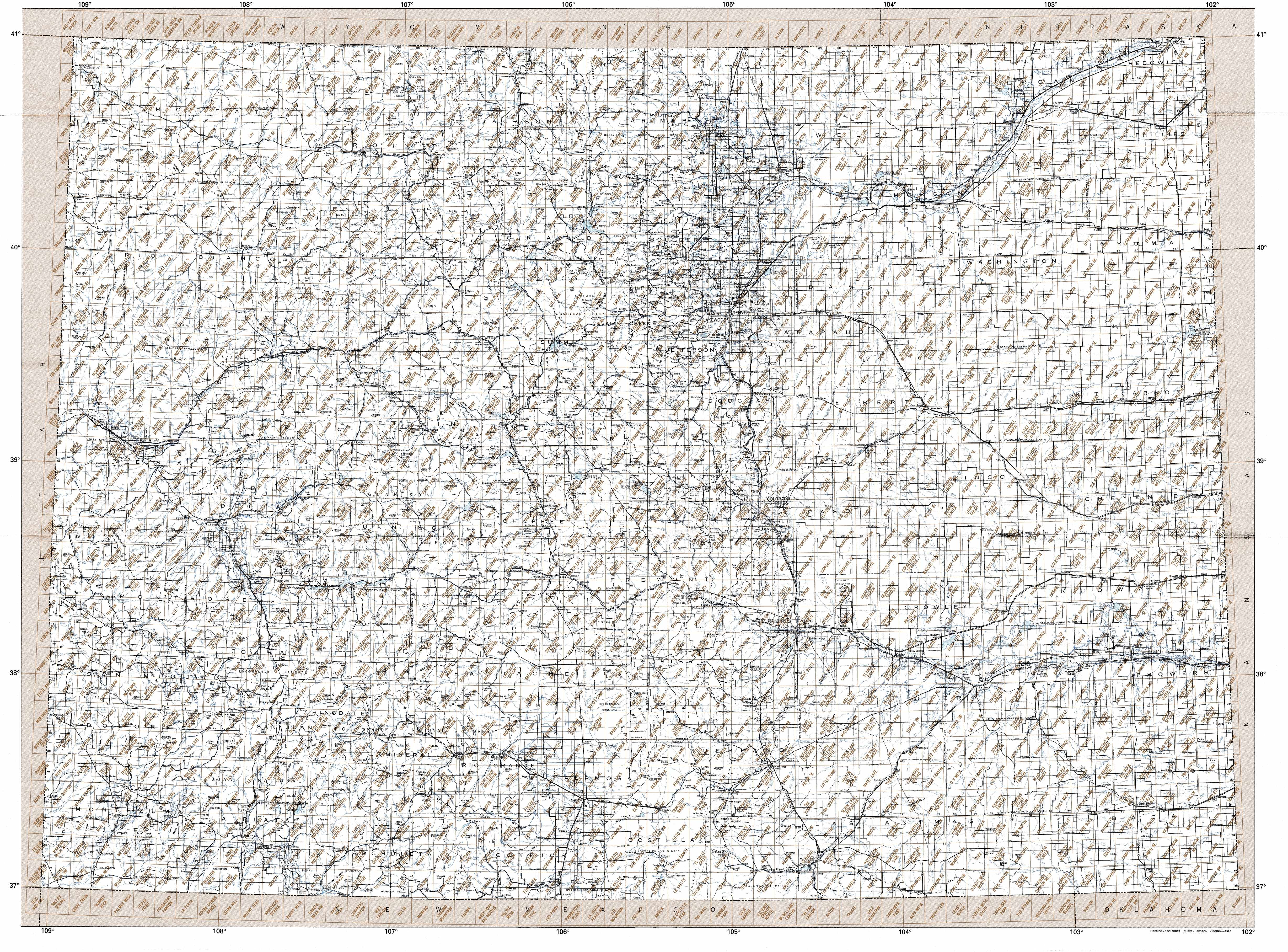
Hover over the index map to the left to view detailed zoom.
You can also download this index map here:
Colorado topo index map at 1:24,000 Scale
24k CO topographic maps:
(This is a small selection to get you started. Use the complete list of 250k or 100k maps further below to drill down to your area of choice.)
40108h8 Beaver Basin, CO
40108h7 Sparks, CO
40108h6 Sugarloaf Butte, CO
40108h5 Hiawatha, CO
40108h4 Coffee Pot Spring, CO
40108h3 Powder Wash, CO
40108h2 Reservoir Draw, CO
40108h1 The Nipple Ne, CO
40107h8 Bighole Butte, CO
40107h7 Thornburgh Gulch, CO
40107h6 Pole Gulch, CO
40107h5 Fortification Ne, CO
40107h4 Bakers Peak, CO
40107h3 Fly Creek, CO
40107h2 Tumble Mountain, CO
40107h1 Shield Mountain, CO
40106h8 Elkhorn Mountain, CO
40106h7 West Fork Lake, CO
40106h6 Davis Peak, CO
40106h5 Pearl, CO
1:250,000 scale Colorado topo maps
Below you can find the 1:250,000 index map for Colorado state. These topo maps give a general overview of an area and cover a large area: 1° latitude by 2° longitude. A list of all Colorado topo map sheets at 250k follows on the right.
Colorado Topo Index Map: 1:250,000
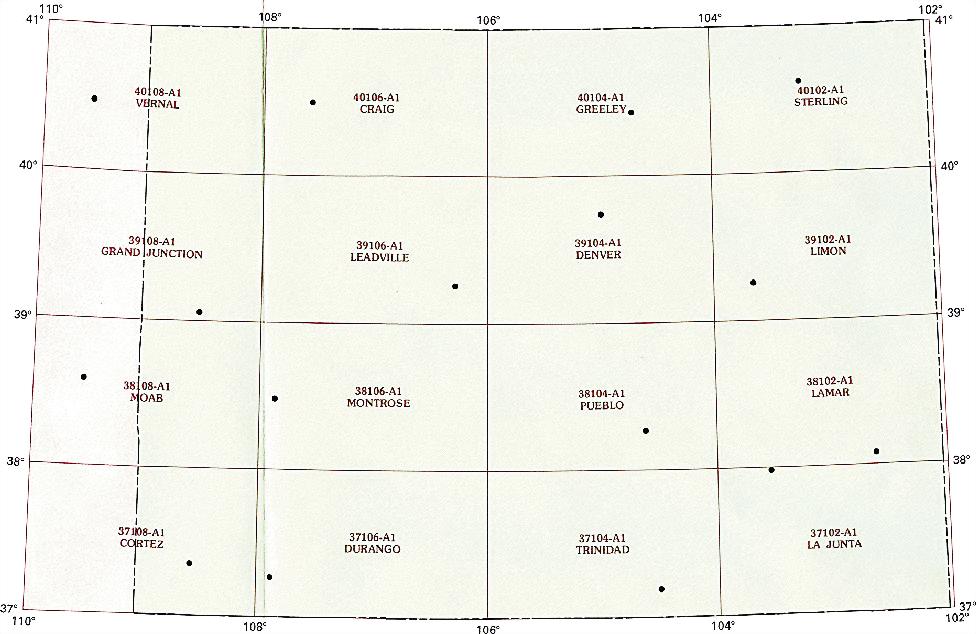
Hover over the index map to the left to view detailed zoom.
You can also download this index map here:
Colorado topo index map at 1:250,000 Scale
250k CO topographic maps:
40108a1 Vernal, CO
40106a1 Craig, CO
40104a1 Greeley, CO
40102a1 Sterling, CO
39108a1 Grand Junction, CO
39106a1 Leadville, CO
39104a1 Denver, CO
39102a1 Limon, CO
38108a1 Moab, CO
38106a1 Montrose, CO
38104a1 Pueblo, CO
38102a1 Lamar, CO
37108a1 Cortez, CO
37106a1 Durango, CO
37104a1 Trinidad, CO
37102a1 La Junta, CO
1:100,000 scale Colorado topo maps
Below you can find the 1:100,000 index map for Colorado state. These topo maps give a more detailed overview of an area and cover a medium-sized area: 0.5° latitude by 1° longitude. A list of all Colorado topo map sheets at 100k follows on the right.
Colorado Topo Index Map: 1:100,000
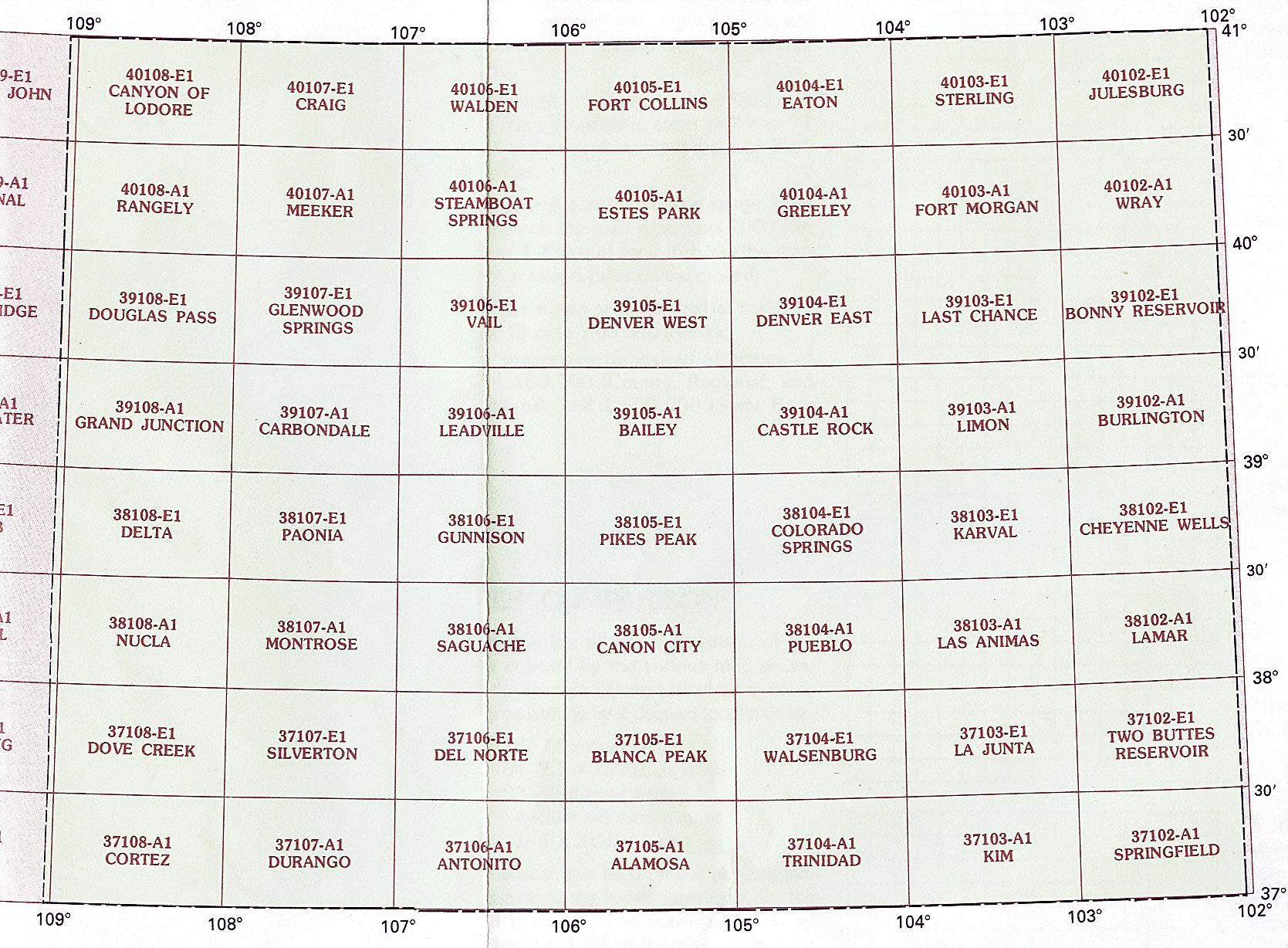
Hover over the index map to the left to view detailed zoom.
You can also download this index map here:
Colorado topo index map at 1:100,000 Scale
100k CO topographic maps:
41109a1 Firehole Canyon, CO
41108a1 Kinney Rim, CO
41107a1 Baggs, CO
41106a1 Saratoga, CO
41104a1 Cheyenne, CO
41103a1 Kimball, CO
41102a1 Chappell, CO
40109e1 Dutch John, CO
40108e1 Canyon Of Lodore, CO
40107e1 Craig, CO
40106e1 Walden, CO
40105e1 Fort Collins, CO
40104e1 Eaton, CO
40103e1 Sterling, CO
40102e1 Julesburg, CO
40109a1 Vernal, CO
40108a1 Rangely, CO
40107a1 Meeker, CO
40106a1 Steamboat Springs, CO
40105a1 Estes Park, CO
40104a1 Greeley, CO
40103a1 Fort Morgan, CO
40102a1 Wray, CO
39109e1 Seep Ridge, CO
39108e1 Douglas Pass, CO
39107e1 Glenwood Springs, CO
39106e1 Vail, CO
39105e1 Denver West, CO
39104e1 Denver East, CO
39103e1 Last Chance, CO
39102e1 Bonny Reservoir, CO
39109a1 Westwater, CO
39108a1 Grand Junction, CO
39107a1 Carbondale, CO
39106a1 Leadville, CO
39105a1 Bailey, CO
39104a1 Castle Rock, CO
39103a1 Limon, CO
39102a1 Burlington, CO
38109e1 Moab, CO
38108e1 Delta, CO
38107e1 Paonia, CO
38106e1 Gunnison, CO
38105e1 Pikes Peak, CO
38104e1 Colorado Springs, CO
38103e1 Karval, CO
38102e1 Cheyenne Wells, CO
38109a1 La Sal, CO
38108a1 Nucla, CO
38107a1 Montrose, CO
38106a1 Saguache, CO
38105a1 Canon City, CO
38104a1 Pueblo, CO
38103a1 Las Animas, CO
38102a1 Lamar, CO
37109e1 Blanding, CO
37108e1 Dove Creek, CO
37107e1 Silverton, CO
37106e1 Del Norte, CO
37105e1 Blanca Peak, CO
37104e1 Walsenburg, CO
37103e1 La Junta, CO
37102e1 Two Buttes Reservoir, CO
37109a1 Bluff, CO
37108a1 Cortez, CO
37107a1 Durango, CO
37106a1 Antonito, CO
37105a1 Alamosa, CO
37104a1 Trinidad, CO
37103a1 Kim, CO
37102a1 Springfield, CO
36109e1 Rock Point, CO
36108e1 Farmington, CO
36107e1 Navajo Reservoir, CO
36106e1 Chama, CO
36105e1 Wheeler Peak, CO
36104e1 Raton, CO
36103e1 Capulin Mountain, CO
36102e1 Boise City, CO