South Dakota topographic maps
These topographic index maps for South Dakota state are provided by the U.S. Geological Survey (USGS) for map sheet identification. To locate the USGS topo quad in South Dakota that you are trying to find, look at the index map of the appropriate map scale.
1:24,000 scale South Dakota topo quads
The index map below is for South Dakota topo quads at 1:24,000 scale. It is zoomable, and you can find the name of the 1:24,000 scale map (sometimes abbreviated as "24k") written diagonally across rectangular boxes that define the borders of the individual 24k map sheets.
Note that a rare few of the 1:24,000 scale (aka 7.5 minute) maps in South Dakota state might actually be at 1:25,000 scale, which is a very minor difference in map scale. Some of these 1:25,000 scale maps also cover a larger area than regular 7.5 minute maps. Those maps are 7.5´x15´ topo quads, and can be identified on the index map below by a larger sized rectangle that is twice as wide as usual (covers twice the longitude). The map names for these sheets are labelled horizontally, not diagonally.
South Dakota Topo Index Map: 1:24,000
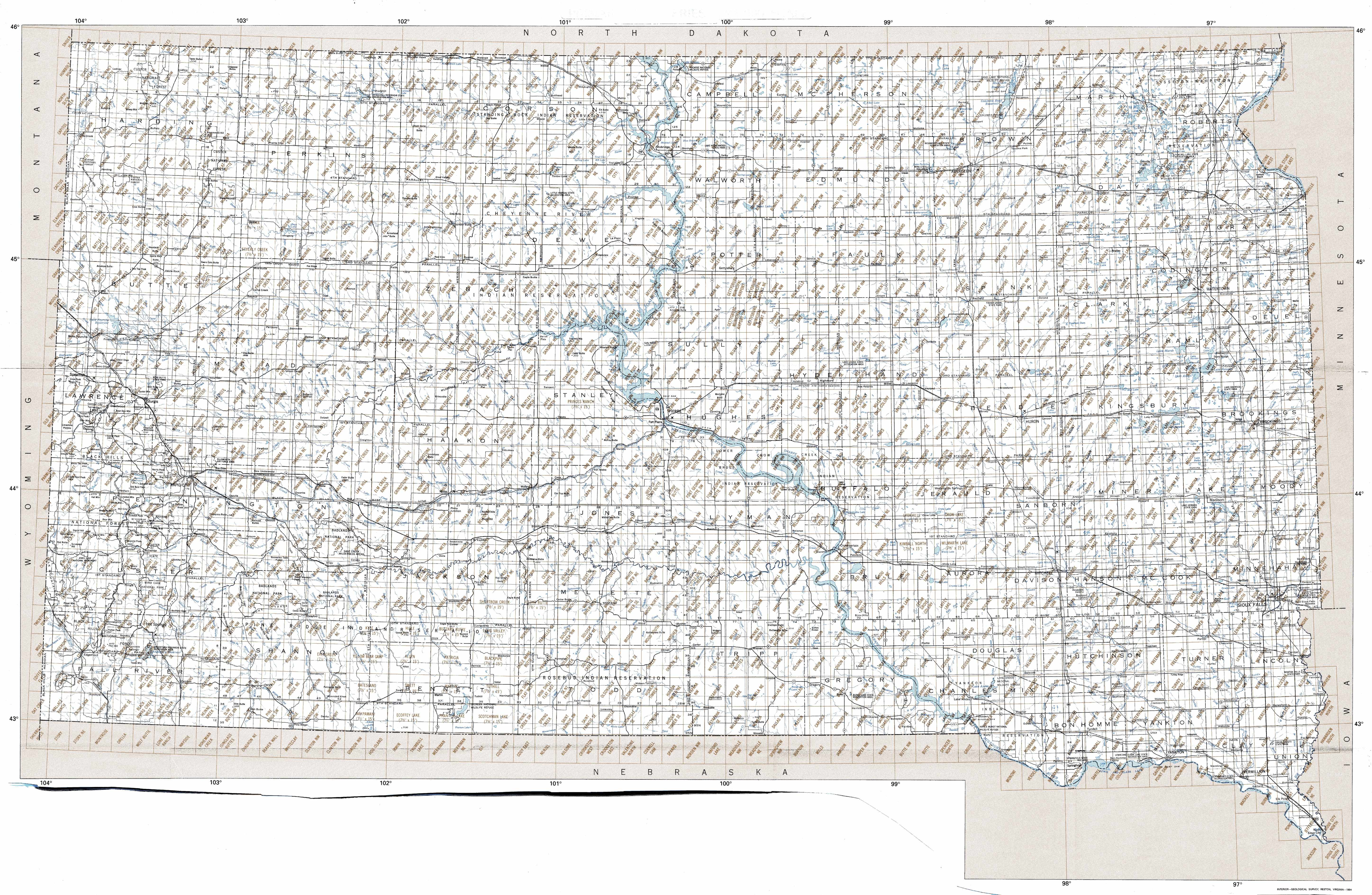
Hover over the index map to the left to view detailed zoom.
You can also download this index map here:
South Dakota topo index map at 1:24,000 Scale
24k SD topographic maps:
(This is a small selection to get you started. Use the complete list of 250k or 100k maps further below to drill down to your area of choice.)
45103h8 Doaks Butte, SD
45103h7 Dogie Butte, SD
45103h6 Table Mountain, SD
45103h5 Ladner Ne, SD
45103h4 Eagles Nest Butte, SD
45103h3 Tepee Buttes, SD
45103h2 Bowman-Haley Dam, SD
45103h1 Haley, SD
45102h8 Cow Butte, SD
45102h7 Cow Butte Ne, SD
45102h6 Hettinger South, SD
45102h5 Kid Rich Butte, SD
45102h4 Haynes, SD
45102h3 White Butte, SD
45102h2 Lemmon, SD
45102h1 Lemmon Ne, SD
45101h8 Thunder Hawk, SD
45101h7 Keldron, SD
45101h6 Morristown, SD
45101h5 Watauga, SD
1:250,000 scale South Dakota topo maps
Below you can find the 1:250,000 index map for South Dakota state. These topo maps give a general overview of an area and cover a large area: 1° latitude by 2° longitude. A list of all South Dakota topo map sheets at 250k follows on the right.
South Dakota Topo Index Map: 1:250,000
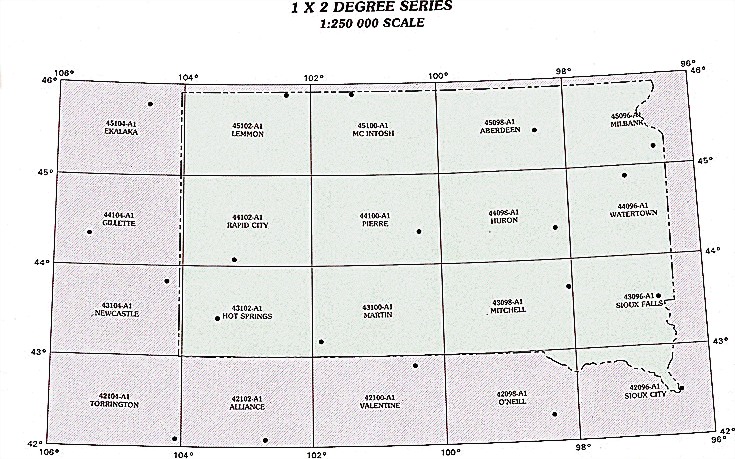
Hover over the index map to the left to view detailed zoom.
You can also download this index map here:
South Dakota topo index map at 1:250,000 Scale
250k SD topographic maps:
45104a1 Ekalaka, SD
45102a1 Lemmon, SD
45100a1 Mc Intosh, SD
45098a1 Aberdeen, SD
45096a1 Milbank, SD
44104a1 Gillette, SD
44102a1 Rapid City, SD
44100a1 Pierre, SD
44098a1 Huron, SD
44096a1 Watertown, SD
43104a1 Newcastle, SD
43102a1 Hot Springs, SD
43100a1 Martin, SD
43098a1 Mitchell, SD
43096a1 Sioux Falls, SD
42098a1 O'Neill, SD
42096a1 Sioux City, SD
1:100,000 scale South Dakota topo maps
Below you can find the 1:100,000 index map for South Dakota state. These topo maps give a more detailed overview of an area and cover a medium-sized area: 0.5° latitude by 1° longitude. A list of all South Dakota topo map sheets at 100k follows on the right.
South Dakota Topo Index Map: 1:100,000

Hover over the index map to the left to view detailed zoom.
You can also download this index map here:
South Dakota topo index map at 1:100,000 Scale
100k SD topographic maps:
45104e1 Ekalaka, SD
45103e1 Camp Crook, SD
45102e1 Lemmon, SD
45101e1 Mc Intosh, SD
45100e1 Mobridge, SD
45099e1 Eureka, SD
45098e1 Elm River, SD
45097e1 Sisseton, SD
45096e1 Wheaton, SD
45104a1 Alzada, SD
45103a1 Redig, SD
45102a1 Faith, SD
45101a1 Timber Lake, SD
45100a1 La Plant, SD
45099a1 Gettysburg, SD
45098a1 Aberdeen, SD
45097a1 Webster, SD
45096a1 Milbank, SD
44104e1 Devils Tower, SD
44103e1 Belle Fourche, SD
44102e1 Camp Creek, SD
44101e1 Cherry Creek, SD
44100e1 Onida, SD
44099e1 Highmore, SD
44098e1 Redfield, SD
44097e1 Watertown, SD
44096e1 Clear Lake, SD
44104a1 Sundance, SD
44103a1 Rapid City, SD
44102a1 New Underwood, SD
44101a1 Philip, SD
44100a1 Pierre, SD
44099a1 Big Bend Dam, SD
44098a1 Huron, SD
44097a1 De Smet, SD
44096a1 Brookings, SD
43104e1 Newcastle, SD
43103e1 Mount Rushmore, SD
43102e1 Wall, SD
43101e1 Kadoka, SD
43100e1 White River, SD
43099e1 Chamberlain, SD
43098e1 Mitchell, SD
43097e1 Salem, SD
43096e1 Sioux Falls, SD
43104a1 Lance Creek, SD
43103a1 Hot Springs, SD
43102a1 Pine Ridge, SD
43101a1 Martin, SD
43100a1 Mission, SD
43099a1 Winner, SD
43098a1 Lake Andes, SD
43097a1 Freeman, SD
43096a1 Rock Rapids, SD
42102e1 Gordon, SD
42101e1 Cody, SD
42100e1 Valentine, SD
42099e1 Ainsworth, SD
42098e1 Atkinson, SD
42097e1 Yankton, SD
42096e1 Sioux City North, SD
42096a1 Sioux City South, SD