Mississippi topographic maps
These topographic index maps for Mississippi state are provided by the U.S. Geological Survey (USGS) for map sheet identification. To locate the USGS topo quad in Mississippi that you are trying to find, look at the index map of the appropriate map scale.
1:24,000 scale Mississippi topo quads
The index map below is for Mississippi topo quads at 1:24,000 scale. It is zoomable, and you can find the name of the 1:24,000 scale map (sometimes abbreviated as "24k") written diagonally across rectangular boxes that define the borders of the individual 24k map sheets.
Note that a rare few of the 1:24,000 scale (aka 7.5 minute) maps in Mississippi state might actually be at 1:25,000 scale, which is a very minor difference in map scale. Some of these 1:25,000 scale maps also cover a larger area than regular 7.5 minute maps. Those maps are 7.5´x15´ topo quads, and can be identified on the index map below by a larger sized rectangle that is twice as wide as usual (covers twice the longitude). The map names for these sheets are labelled horizontally, not diagonally.
Mississippi Topo Index Map: 1:24,000
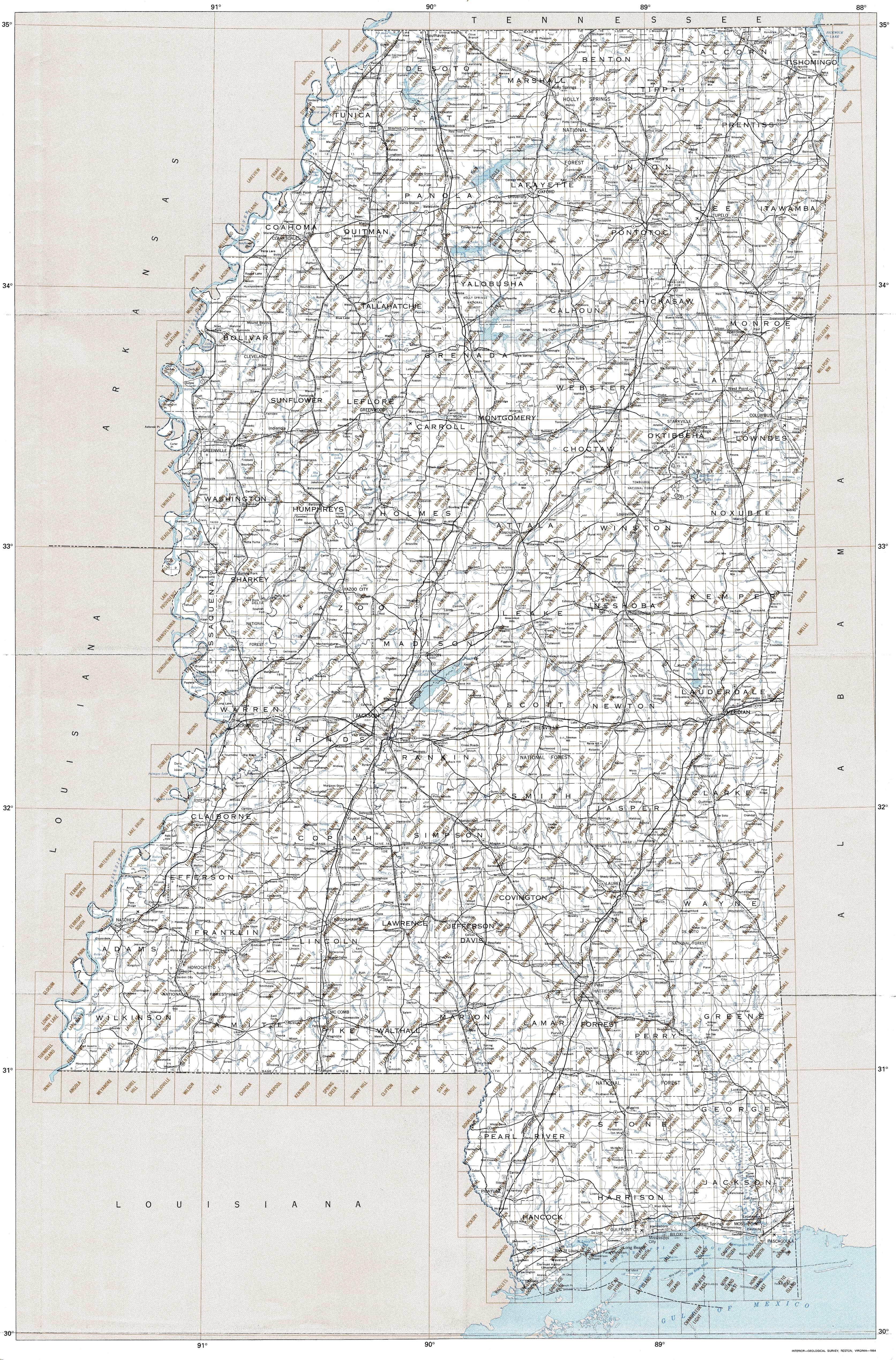
Hover over the index map to the left to view detailed zoom.
You can also download this index map here:
Mississippi topo index map at 1:24,000 Scale
24k MS topographic maps:
(This is a small selection to get you started. Use the complete list of 250k or 100k maps further below to drill down to your area of choice.)
34090h2 Lake Cormorant, MS
34090h1 Horn Lake, MS
34089h8 Pleasant Hill, MS
34089h7 Olive Branch, MS
34089h6 Byhalia Nw, MS
34089h5 Mount Pleasant, MS
34089h4 Slayden, MS
34089h3 Lamar, MS
34089h2 Canaan, MS
34089h1 Camp Hill, MS
34088h8 Walnut, MS
34088h7 Chalybeate, MS
34088h6 Kossuth North, MS
34088h5 Corinth, MS
34088h4 Kendrick, MS
34088h3 Doskie, MS
34088h2 Yellow Creek, MS
34090g3 Robinsonville, MS
34090g2 Banks, MS
34090g1 Frees Corners, MS
1:250,000 scale Mississippi topo maps
Below you can find the 1:250,000 index map for Mississippi state. These topo maps give a general overview of an area and cover a large area: 1° latitude by 2° longitude. A list of all Mississippi topo map sheets at 250k follows on the right.
Mississippi Topo Index Map: 1:250,000
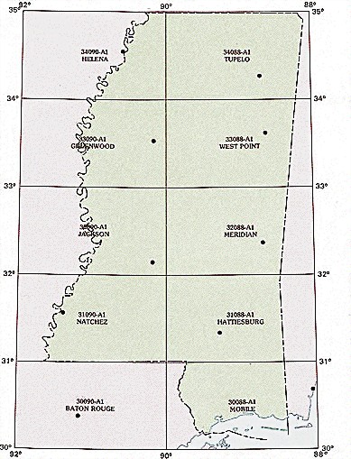
Hover over the index map to the left to view detailed zoom.
You can also download this index map here:
Mississippi topo index map at 1:250,000 Scale
250k MS topographic maps:
34090a1 Helena, MS
34088a1 Tupelo, MS
33090a1 Greenwood, MS
33088a1 West Point, MS
32090a1 Jackson, MS
32088a1 Meridian, MS
31090a1 Natchez, MS
31088a1 Hattiesburg, MS
30088a1 Mobile, MS
1:100,000 scale Mississippi topo maps
Below you can find the 1:100,000 index map for Mississippi state. These topo maps give a more detailed overview of an area and cover a medium-sized area: 0.5° latitude by 1° longitude. A list of all Mississippi topo map sheets at 100k follows on the right.
Mississippi Topo Index Map: 1:100,000
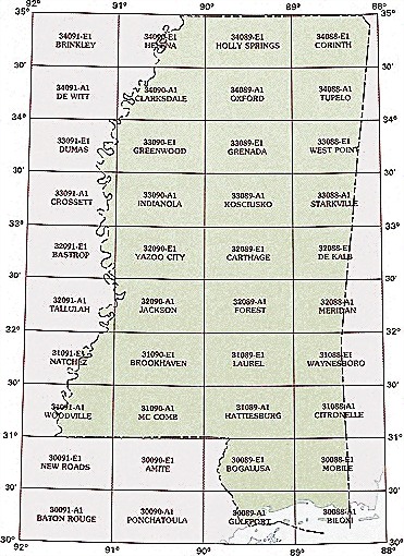
Hover over the index map to the left to view detailed zoom.
You can also download this index map here:
Mississippi topo index map at 1:100,000 Scale
100k MS topographic maps:
34090e1 Helena, MS
34089e1 Holly Springs, MS
34088e1 Corinth, MS
34091a1 De Witt, MS
34090a1 Clarksdale, MS
34089a1 Oxford, MS
34088a1 Tupelo, MS
33091e1 Dumas, MS
33090e1 Greenwood, MS
33089e1 Grenada, MS
33088e1 West Point, MS
33091a1 Crossett, MS
33090a1 Indianola, MS
33089a1 Kosciusko, MS
33088a1 Starkville, MS
32091e1 Bastrop, MS
32090e1 Yazoo City, MS
32089e1 Carthage, MS
32088e1 De Kalb, MS
32091a1 Tallulah, MS
32090a1 Jackson, MS
32089a1 Forest, MS
32088a1 Meridian, MS
31091e1 Natchez, MS
31090e1 Brookhaven, MS
31089e1 Laurel, MS
31088e1 Waynesboro, MS
31091a1 Woodville, MS
31090a1 Mc Comb, MS
31089a1 Hattiesburg, MS
31088a1 Citronelle, MS
30091e1 New Roads, MS
30090e1 Amite, MS
30089e1 Bogalusa, MS
30088e1 Mobile, MS
30089a1 Gulfport, MS
30088a1 Biloxi, MS