West Virginia topographic maps
These topographic index maps for West Virginia state are provided by the U.S. Geological Survey (USGS) for map sheet identification. To locate the USGS topo quad in West Virginia that you are trying to find, look at the index map of the appropriate map scale.
1:24,000 scale West Virginia topo quads
The index map below is for West Virginia topo quads at 1:24,000 scale. It is zoomable, and you can find the name of the 1:24,000 scale map (sometimes abbreviated as "24k") written diagonally across rectangular boxes that define the borders of the individual 24k map sheets.
Note that a rare few of the 1:24,000 scale (aka 7.5 minute) maps in West Virginia state might actually be at 1:25,000 scale, which is a very minor difference in map scale. Some of these 1:25,000 scale maps also cover a larger area than regular 7.5 minute maps. Those maps are 7.5´x15´ topo quads, and can be identified on the index map below by a larger sized rectangle that is twice as wide as usual (covers twice the longitude). The map names for these sheets are labelled horizontally, not diagonally.
West Virginia Topo Index Map: 1:24,000

Hover over the index map to the left to view detailed zoom.
You can also download this index map here:
West Virginia topo index map at 1:24,000 Scale
24k WV topographic maps:
(This is a small selection to get you started. Use the complete list of 250k or 100k maps further below to drill down to your area of choice.)
40080e5 East Liverpool South, WV
40080d5 Weirton, WV
40080c5 Steubenville East, WV
40080b5 Bethany, WV
40080a6 Wheeling, WV
40080a5 Valley Grove, WV
39080h6 Moundsville, WV
39080h5 Majorsville, WV
39080g7 Powhatan Point, WV
39080g6 Glen Easton, WV
39080g5 Cameron, WV
39080f7 New Martinsville, WV
39080f6 Wileyville, WV
39080f5 Littleton, WV
39080f4 Hundred, WV
39080f3 Wadestown, WV
39080f2 Blacksville, WV
39080f1 Osage, WV
39079f8 Morgantown North, WV
39079f7 Lake Lynn, WV
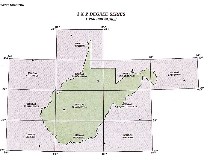
1:250,000 scale West Virginia topo maps
Below you can find the 1:250,000 index map for West Virginia state. These topo maps give a general overview of an area and cover a large area: 1° latitude by 2° longitude. A list of all West Virginia topo map sheets at 250k follows on the right.
West Virginia Topo Index Map: 1:250,000
Hover over the index map to the left to view detailed zoom.
You can also download this index map here:
West Virginia topo index map at 1:250,000 Scale
250k WV topographic maps:
40080a1 Canton, WV
39080a1 Clarksburg, WV
39078a1 Cumberland, WV
39076a1 Baltimore, WV
38082a1 Huntington, WV
38080a1 Charleston, WV
38078a1 Charlottesville, WV
37082a1 Jenkins, WV
37080a1 Bluefield, WV
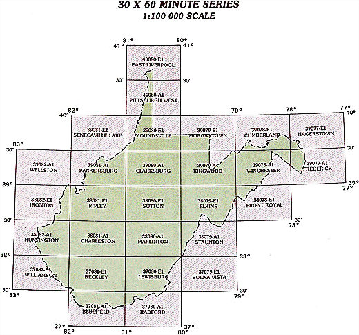
1:100,000 scale West Virginia topo maps
Below you can find the 1:100,000 index map for West Virginia state. These topo maps give a more detailed overview of an area and cover a medium-sized area: 0.5° latitude by 1° longitude. A list of all West Virginia topo map sheets at 100k follows on the right.
West Virginia Topo Index Map: 1:100,000
Hover over the index map to the left to view detailed zoom.
You can also download this index map here:
West Virginia topo index map at 1:100,000 Scale
100k WV topographic maps:
40080e1 East Liverpool, WV
40080a1 Pittsburgh West, WV
39081e1 Senecaville Lake, WV
39080e1 Moundsville, WV
39079e1 Morgantown, WV
39078e1 Cumberland, WV
39077e1 Hagerstown, WV
39082a1 Wellston, WV
39081a1 Parkersburg, WV
39080a1 Clarksburg, WV
39079a1 Kingwood, WV
39078a1 Winchester, WV
39077a1 Frederick, WV
38082e1 Ironton, WV
38081e1 Ripley, WV
38080e1 Sutton, WV
38079e1 Elkins, WV
38078e1 Front Royal, WV
38082a1 Huntington, WV
38081a1 Charleston, WV
38080a1 Marlinton, WV
38079a1 Staunton, WV
37082e1 Williamson, WV
37081e1 Beckley, WV
37080e1 Lewisburg, WV
37079e1 Buena Vista, WV
37081a1 Bluefield, WV
37080a1 Radford, WV