Idaho topographic maps
These topographic index maps for Idaho state are provided by the U.S. Geological Survey (USGS) for map sheet identification. To locate the USGS topo quad in Idaho that you are trying to find, look at the index map of the appropriate map scale.
1:24,000 scale Idaho topo quads
The index map below is for Idaho topo quads at 1:24,000 scale. It is zoomable, and you can find the name of the 1:24,000 scale map (sometimes abbreviated as "24k") written diagonally across rectangular boxes that define the borders of the individual 24k map sheets.
Note that a rare few of the 1:24,000 scale (aka 7.5 minute) maps in Idaho state might actually be at 1:25,000 scale, which is a very minor difference in map scale. Some of these 1:25,000 scale maps also cover a larger area than regular 7.5 minute maps. Those maps are 7.5´x15´ topo quads, and can be identified on the index map below by a larger sized rectangle that is twice as wide as usual (covers twice the longitude). The map names for these sheets are labelled horizontally, not diagonally.
Idaho Topo Index Map: 1:24,000

Hover over the index map to the left to view detailed zoom.
You can also download this index map here:
Idaho topo index map at 1:24,000 Scale
24k ID topographic maps:
(This is a small selection to get you started. Use the complete list of 250k or 100k maps further below to drill down to your area of choice.)
48116h8 Continental Mountain, ID
48116h7 Grass Mountain, ID
48116h6 Shorty Peak, ID
48116h5 Smith Falls, ID
48116h4 Copeland, ID
48116h3 Hall Mountain, ID
48116h2 Eastport, ID
48116h1 Canuck Peak, ID
48116g8 Upper Priest Lake, ID
48116g7 Caribou Creek, ID
48116g6 Smith Peak, ID
48116g5 Pyramid Peak, ID
48116g4 Farnham Peak, ID
48116g3 Ritz, ID
48116g2 Meadow Creek, ID
48116g1 Line Point, ID
48116f8 Priest Lake Nw, ID
48116f7 Priest Lake Ne, ID
48116f6 The Wigwams, ID
48116f5 Roman Nose, ID
1:250,000 scale Idaho topo maps
Below you can find the 1:250,000 index map for Idaho state. These topo maps give a general overview of an area and cover a large area: 1° latitude by 2° longitude. A list of all Idaho topo map sheets at 250k follows on the right.
Idaho Topo Index Map: 1:250,000
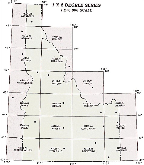
Hover over the index map to the left to view detailed zoom.
You can also download this index map here:
Idaho topo index map at 1:250,000 Scale
250k ID topographic maps:
48116a1 Sandpoint, ID
47116a1 Spokane, ID
47114a1 Wallace, ID
46116a1 Pullman, ID
46114a1 Hamilton, ID
45116a1 Grangeville, ID
45114a1 Elk City, ID
45112a1 Dillon, ID
44116a1 Baker, ID
44114a1 Challis, ID
44112a1 Dubois, ID
44110a1 Ashton, ID
43116a1 Boise, ID
43114a1 Hailey, ID
43112a1 Idaho Falls, ID
43110a1 Driggs, ID
42116a1 Jordan Valley, ID
42114a1 Twin Falls, ID
42112a1 Pocatello, ID
42110a1 Preston, ID
1:100,000 scale Idaho topo maps
Below you can find the 1:100,000 index map for Idaho state. These topo maps give a more detailed overview of an area and cover a medium-sized area: 0.5° latitude by 1° longitude. A list of all Idaho topo map sheets at 100k follows on the right.
Idaho Topo Index Map: 1:100,000
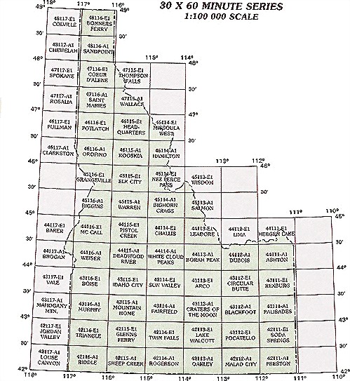
Hover over the index map to the left to view detailed zoom.
You can also download this index map here:
Idaho topo index map at 1:100,000 Scale
100k ID topographic maps:
48117e1 Colville, ID
48116e1 Bonners Ferry, ID
48117a1 Chewelah, ID
48116a1 Sandpoint, ID
47117e1 Spokane, ID
47116e1 Coeur D'Alene, ID
47115e1 Thompson Falls, ID
47117a1 Rosalia, ID
47116a1 Saint Maries, ID
47115a1 Wallace, ID
46117e1 Pullman, ID
46116e1 Potlatch, ID
46115e1 Headquarters, ID
46114e1 Missoula West, ID
46117a1 Clarkston, ID
46116a1 Orofino, ID
46115a1 Kooskia, ID
46114a1 Hamilton, ID
45116e1 Grangeville, ID
45115e1 Elk City, ID
45114e1 Nez Perce Pass, ID
45113e1 Wisdom, ID
45116a1 Riggins, ID
45115a1 Warren, ID
45114a1 Bighorn Crags, ID
45113a1 Salmon, ID
44117e1 Baker, ID
44116e1 Mc Call, ID
44115e1 Pistol Creek, ID
44114e1 Challis, ID
44113e1 Leadore, ID
44112e1 Lima, ID
44111e1 Hebgen Lake, ID
44117a1 Brogan, ID
44116a1 Weiser, ID
44115a1 Deadwood River, ID
44114a1 White Cloud Peaks, ID
44113a1 Borah Peak, ID
44112a1 Dubois, ID
44111a1 Ashton, ID
43117e1 Vale, ID
43116e1 Boise, ID
43115e1 Idaho City, ID
43114e1 Sun Valley, ID
43113e1 Arco, ID
43112e1 Circular Butte, ID
43111e1 Rexburg, ID
43117a1 Mahogany Mountain, ID
43116a1 Murphy, ID
43115a1 Mountain Home, ID
43114a1 Fairfield, ID
43113a1 Craters Of The Moon, ID
43112a1 Blackfoot, ID
43111a1 Palisades, ID
42117e1 Jordan Valley, ID
42116e1 Triangle, ID
42115e1 Glenns Ferry, ID
42114e1 Twin Falls, ID
42113e1 Lake Walcott, ID
42112e1 Pocatello, ID
42111e1 Soda Springs, ID
42117a1 Louse Canyon, ID
42116a1 Riddle, ID
42115a1 Sheep Creek, ID
42114a1 Rogerson, ID
42113a1 Oakley, ID
42112a1 Malad City, ID
42111a1 Preston, ID
41116e1 Bull Run Mountains, ID
41115e1 Jarbidge Mountains, ID
41114e1 Jackpot, ID
41113e1 Grouse Creek, ID
41112e1 Tremonton, ID
41111e1 Logan, ID