Rhode Island topographic maps
These topographic index maps for Rhode Island state are provided by the U.S. Geological Survey (USGS) for map sheet identification. To locate the USGS topo quad in Rhode Island that you are trying to find, look at the index map of the appropriate map scale.
1:24,000 scale Rhode Island topo quads
The index map below is for Rhode Island topo quads at 1:24,000 scale. It is zoomable, and you can find the name of the 1:24,000 scale map (sometimes abbreviated as "24k") written diagonally across rectangular boxes that define the borders of the individual 24k map sheets.
Note that a rare few of the 1:24,000 scale (aka 7.5 minute) maps in Rhode Island state might actually be at 1:25,000 scale, which is a very minor difference in map scale. Some of these 1:25,000 scale maps also cover a larger area than regular 7.5 minute maps. Those maps are 7.5´x15´ topo quads, and can be identified on the index map below by a larger sized rectangle that is twice as wide as usual (covers twice the longitude). The map names for these sheets are labelled horizontally, not diagonally.
Rhode Island Topo Index Map: 1:24,000
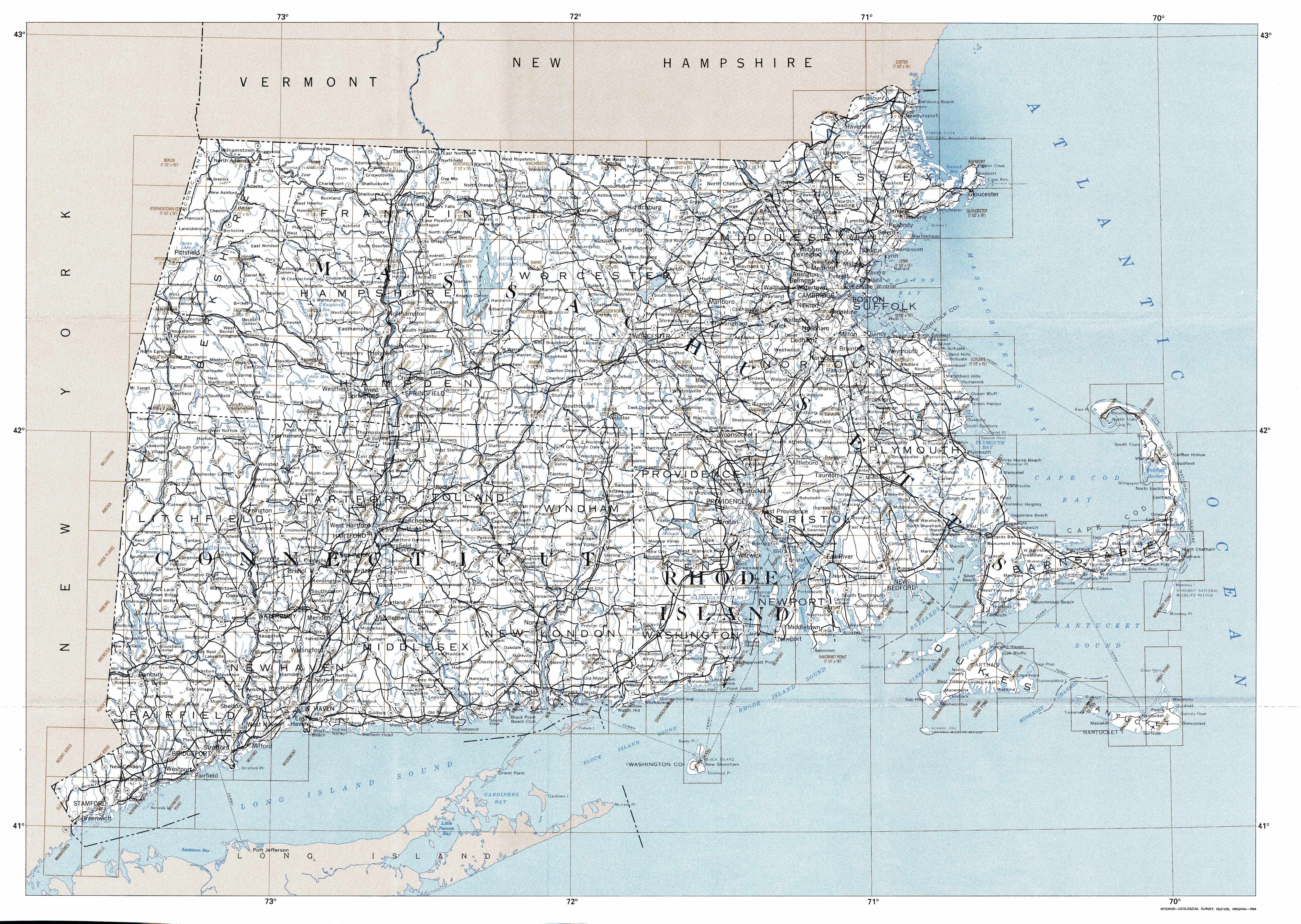
Hover over the index map to the left to view detailed zoom.
You can also download this index map here:
Rhode Island topo index map at 1:24,000 Scale
24k RI topographic maps:
(This is a small selection to get you started. Use the complete list of 250k or 100k maps further below to drill down to your area of choice.)
41071h6 Chepachet, RI
41071h5 Georgiaville, RI
41071g6 Clayville, RI
41071g5 North Scituate, RI
41071f6 Coventry Center, RI
41071f5 Crompton, RI
41071f4 East Greenwich, RI
41071f3 Bristol, RI
41071e6 Hope Valley, RI
41071e5 Slocum, RI
41071e4 Wickford, RI
41071e3 Prudence Island, RI
41071d6 Carolina, RI
41071d5 Kingston, RI
41071d4 Narragansett Pier, RI
41071d3 Newport, RI
41071c6 Quonochontaug, RI
41071b5 Block Island, RI
1:250,000 scale Rhode Island topo maps
Below you can find the 1:250,000 index map for Rhode Island state. These topo maps give a general overview of an area and cover a large area: 1° latitude by 2° longitude. A list of all Rhode Island topo map sheets at 250k follows on the right.
Rhode Island Topo Index Map: 1:250,000
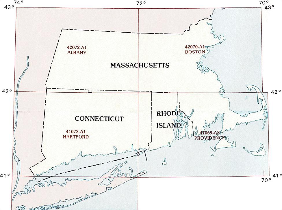
Hover over the index map to the left to view detailed zoom.
You can also download this index map here:
Rhode Island topo index map at 1:250,000 Scale
250k RI topographic maps:
1:100,000 scale Rhode Island topo maps
Below you can find the 1:100,000 index map for Rhode Island state. These topo maps give a more detailed overview of an area and cover a medium-sized area: 0.5° latitude by 1° longitude. A list of all Rhode Island topo map sheets at 100k follows on the right.
Rhode Island Topo Index Map: 1:100,000
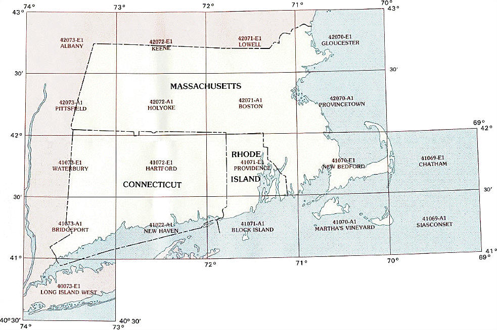
Hover over the index map to the left to view detailed zoom.
You can also download this index map here:
Rhode Island topo index map at 1:100,000 Scale
100k RI topographic maps:
42071a1 Boston, RI
41071e1 Providence, RI
41071a1 Block Island, RI