Oregon topographic maps
These topographic index maps for Oregon state are provided by the U.S. Geological Survey (USGS) for map sheet identification. To locate the USGS topo quad in Oregon that you are trying to find, look at the index map of the appropriate map scale.
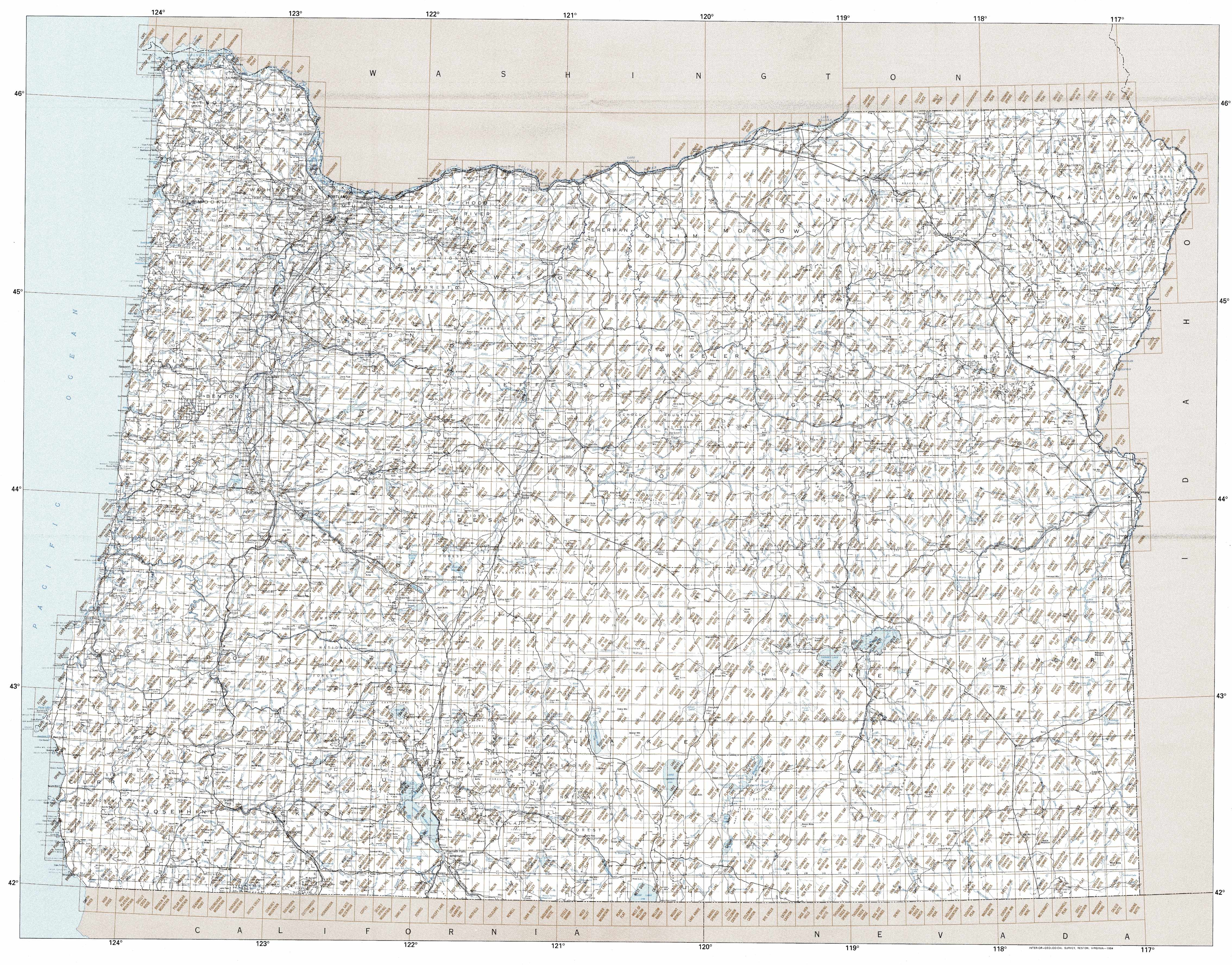
1:24,000 scale Oregon topo quads
The index map below is for Oregon topo quads at 1:24,000 scale. It is zoomable, and you can find the name of the 1:24,000 scale map (sometimes abbreviated as "24k") written diagonally across rectangular boxes that define the borders of the individual 24k map sheets.
Note that a rare few of the 1:24,000 scale (aka 7.5 minute) maps in Oregon state might actually be at 1:25,000 scale, which is a very minor difference in map scale. Some of these 1:25,000 scale maps also cover a larger area than regular 7.5 minute maps. Those maps are 7.5´x15´ topo quads, and can be identified on the index map below by a larger sized rectangle that is twice as wide as usual (covers twice the longitude). The map names for these sheets are labelled horizontally, not diagonally.
Oregon Topo Index Map: 1:24,000
Hover over the index map to the left to view detailed zoom.
You can also download this index map here:
Oregon topo index map at 1:24,000 Scale
24k OR topographic maps:
(This is a small selection to get you started. Use the complete list of 250k or 100k maps further below to drill down to your area of choice.)
46124b1 Clatsop Spit, OR
46123b8 Warrenton, OR
46123b7 Astoria, OR
46123b6 Cathlamet Bay, OR
46123b5 Knappa, OR
46123b4 Cathlamet, OR
46123a8 Gearhart, OR
46123a7 Olney, OR
46123a6 Green Mountain, OR
46123a5 Wickiup Mountain, OR
46123a4 Nicolai Mountain, OR
46123a3 Marshland, OR
46123a2 Clatskanie, OR
46123a1 Delena, OR
46122a8 Rainier, OR
45123h8 Tillamook Head, OR
45123h7 Necanicum Junction, OR
45123h6 Saddle Mountain, OR
45123h5 Vinemaple, OR
45123h4 Sager Creek, OR
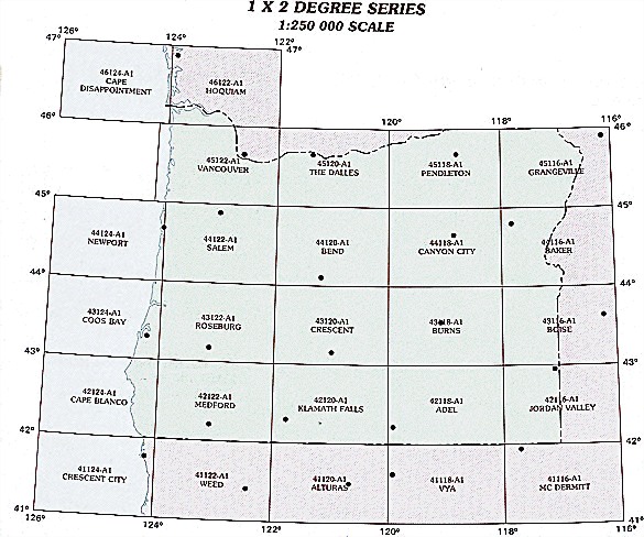
1:250,000 scale Oregon topo maps
Below you can find the 1:250,000 index map for Oregon state. These topo maps give a general overview of an area and cover a large area: 1° latitude by 2° longitude. A list of all Oregon topo map sheets at 250k follows on the right.
Oregon Topo Index Map: 1:250,000
Hover over the index map to the left to view detailed zoom.
You can also download this index map here:
Oregon topo index map at 1:250,000 Scale
250k OR topographic maps:
47124a1 Copalis Beach, OR
46122a1 Hoquiam, OR
45122a1 Vancouver, OR
45120a1 The Dalles, OR
45118a1 Pendleton, OR
45116a1 Grangeville, OR
44124a1 West of Salem, OR
44122a1 Salem, OR
44120a1 Bend, OR
44118a1 Canyon City, OR
44116a1 Baker, OR
43124a1 Coos Bay, OR
43122a1 Roseburg, OR
43120a1 Crescent, OR
43118a1 Burns, OR
43116a1 Boise, OR
42124a1 Coos Bay, OR
42122a1 Medford, OR
42120a1 Klamath Falls, OR
42118a1 Adel, OR
42116a1 Jordan Valley, OR
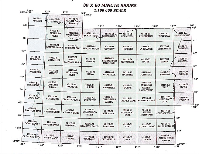
1:100,000 scale Oregon topo maps
Below you can find the 1:100,000 index map for Oregon state. These topo maps give a more detailed overview of an area and cover a medium-sized area: 0.5° latitude by 1° longitude. A list of all Oregon topo map sheets at 100k follows on the right.
Oregon Topo Index Map: 1:100,000
Hover over the index map to the left to view detailed zoom.
You can also download this index map here:
Oregon topo index map at 1:100,000 Scale
100k OR topographic maps:
46124a1 Ilwaco, OR
46123a1 Astoria, OR
46122a1 Mount Saint Helens, OR
46118a1 Walla Walla, OR
46117a1 Clarkston, OR
45123e1 Nehalem River, OR
45122e1 Vancouver, OR
45121e1 Hood River, OR
45120e1 Goldendale, OR
45119e1 Hermiston, OR
45118e1 Pendleton, OR
45117e1 Wallowa, OR
45116e1 Grangeville, OR
45124a1 West Of Yamhill River, OR
45123a1 Yamhill River, OR
45122a1 Oregon City, OR
45121a1 Mount Hood, OR
45120a1 Condon, OR
45119a1 Heppner, OR
45118a1 La Grande, OR
45117a1 Enterprise, OR
45116a1 Riggins, OR
44124e1 Newport, OR
44123e1 Corvallis, OR
44122e1 North Santiam River, OR
44121e1 Madras, OR
44120e1 Stephenson Mountain, OR
44119e1 Monument, OR
44118e1 Bates, OR
44117e1 Baker, OR
44116e1 Mc Call, OR
44124a1 Waldport, OR
44123a1 Eugene, OR
44122a1 Mc Kenzie River, OR
44121a1 Bend, OR
44120a1 Prineville, OR
44119a1 Dayville, OR
44118a1 John Day, OR
44117a1 Brogan, OR
44116a1 Weiser, OR
43124e1 Reedsport, OR
43123e1 Cottage Grove, OR
43122e1 Oakridge, OR
43121e1 La Pine, OR
43120e1 Brothers, OR
43119e1 Burns, OR
43118e1 Stinkingwater Mountains, OR
43117e1 Vale, OR
43116e1 Boise, OR
43124a1 Coos Bay, OR
43123a1 Roseburg, OR
43122a1 Diamond Lake, OR
43121a1 Crescent, OR
43120a1 Christmas Valley, OR
43119a1 Harney Lake, OR
43118a1 Malheur Lake, OR
43117a1 Mahogany Mountain, OR
42124e1 Port Orford, OR
42123e1 Canyonville, OR
42122e1 Crater Lake, OR
42121e1 Williamson River, OR
42120e1 Lake Abert, OR
42119e1 Bluejoint Lake, OR
42118e1 Steens Mountain, OR
42117e1 Jordan Valley, OR
42124a1 Gold Beach, OR
42123a1 Grants Pass, OR
42122a1 Medford, OR
42121a1 Klamath Falls, OR
42120a1 Lakeview, OR
42119a1 Adel, OR
42118a1 Alvord Lake, OR
42117a1 Louse Canyon, OR
41124e1 Crescent City, OR
41123e1 Happy Camp, OR
41121e1 Tulelake, OR
41120e1 Cedarville, OR
41119e1 Vya, OR
41118e1 Denio, OR
41117e1 Quinn River Valley, OR