Virginia topographic maps
These topographic index maps for Virginia state are provided by the U.S. Geological Survey (USGS) for map sheet identification. To locate the USGS topo quad in Virginia that you are trying to find, look at the index map of the appropriate map scale.
1:24,000 scale Virginia topo quads
The index map below is for Virginia topo quads at 1:24,000 scale. It is zoomable, and you can find the name of the 1:24,000 scale map (sometimes abbreviated as "24k") written diagonally across rectangular boxes that define the borders of the individual 24k map sheets.
Note that a rare few of the 1:24,000 scale (aka 7.5 minute) maps in Virginia state might actually be at 1:25,000 scale, which is a very minor difference in map scale. Some of these 1:25,000 scale maps also cover a larger area than regular 7.5 minute maps. Those maps are 7.5´x15´ topo quads, and can be identified on the index map below by a larger sized rectangle that is twice as wide as usual (covers twice the longitude). The map names for these sheets are labelled horizontally, not diagonally.
Virginia Topo Index Map: 1:24,000
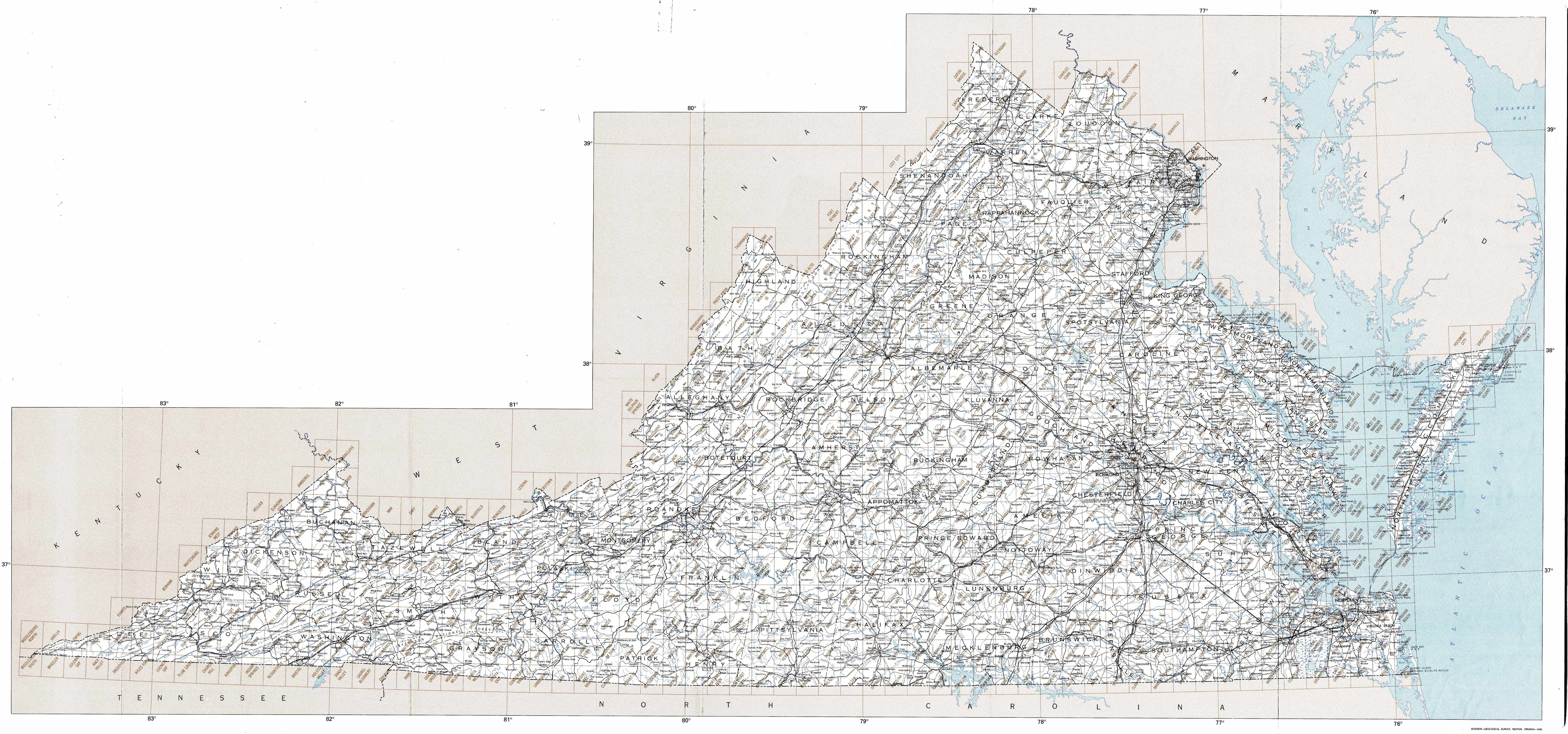
Hover over the index map to the left to view detailed zoom.
You can also download this index map here:
Virginia topo index map at 1:24,000 Scale
24k VA topographic maps:
(This is a small selection to get you started. Use the complete list of 250k or 100k maps further below to drill down to your area of choice.)
39078c3 Gore, VA
39078c2 White Hall, VA
39077c6 Harpers Ferry, VA
39078b3 Hayfield, VA
39078b2 Winchester, VA
39078b1 Stephenson, VA
39077b8 Berryville, VA
39077b6 Purcellville, VA
39077b5 Waterford, VA
39078a4 Mountain Falls, VA
39078a3 Middletown, VA
39078a2 Stephens City, VA
39078a1 Boyce, VA
39077a8 Ashby Gap, VA
39077a7 Bluemont, VA
39077a6 Lincoln, VA
39077a5 Leesburg, VA
39077a4 Sterling, VA
38078h5 Woodstock, VA
38078h4 Toms Brook, VA
1:250,000 scale Virginia topo maps
Below you can find the 1:250,000 index map for Virginia state. These topo maps give a general overview of an area and cover a large area: 1° latitude by 2° longitude. A list of all Virginia topo map sheets at 250k follows on the right.
Virginia Topo Index Map: 1:250,000
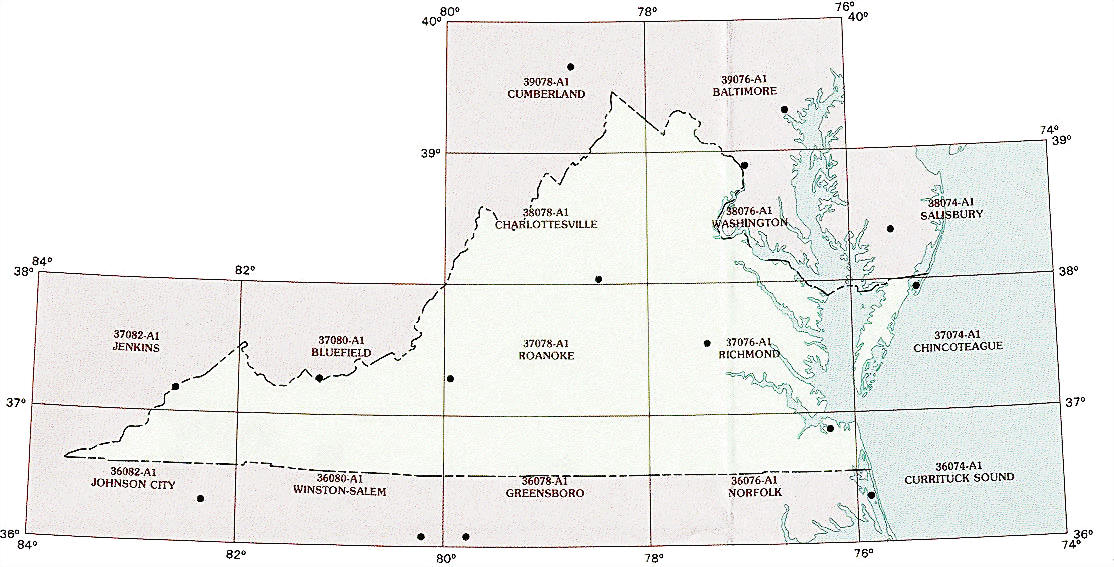
Hover over the index map to the left to view detailed zoom.
You can also download this index map here:
Virginia topo index map at 1:250,000 Scale
250k VA topographic maps:
39078a1 Cumberland, VA
39076a1 Baltimore, VA
38080a1 Charleston, VA
38078a1 Charlottesville, VA
38076a1 Washington, VA
38074a1 Salisbury, VA
37082a1 Jenkins, VA
37080a1 Bluefield, VA
37078a1 Roanoke, VA
37076a1 Richmond, VA
37074a1 Eastville, VA
36082a1 Johnson City, VA
36080a1 Winston-Salem, VA
36078a1 Greensboro, VA
36076a1 Norfolk, VA
36074a1 Currituck Sound, VA
1:100,000 scale Virginia topo maps
Below you can find the 1:100,000 index map for Virginia state. These topo maps give a more detailed overview of an area and cover a medium-sized area: 0.5° latitude by 1° longitude. A list of all Virginia topo map sheets at 100k follows on the right.
Virginia Topo Index Map: 1:100,000
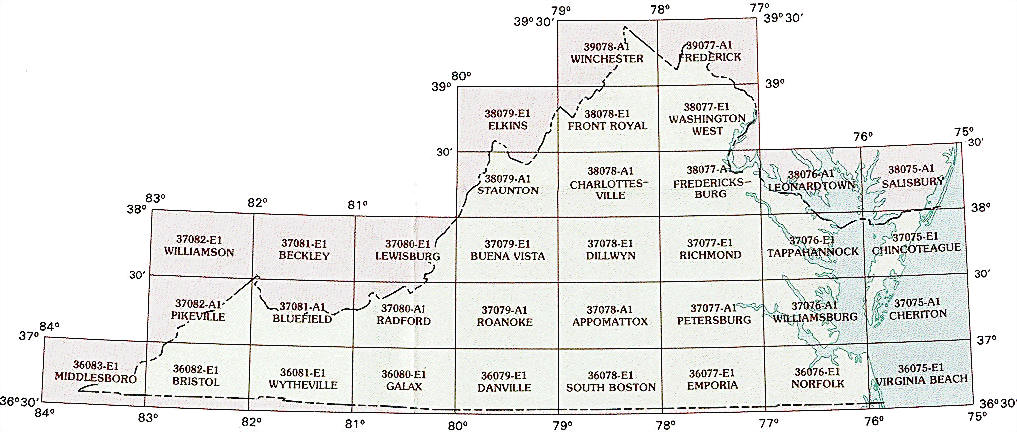
Hover over the index map to the left to view detailed zoom.
You can also download this index map here:
Virginia topo index map at 1:100,000 Scale
100k VA topographic maps:
39078a1 Winchester, VA
39077a1 Frederick, VA
38079e1 Elkins, VA
38078e1 Front Royal, VA
38077e1 Washington West, VA
38079a1 Staunton, VA
38078a1 Charlottesville, VA
38077a1 Fredericksburg, VA
38076a1 Leonardtown, VA
38075a1 Salisbury, VA
37081e1 Beckley, VA
37080e1 Lewisburg, VA
37079e1 Buena Vista, VA
37078e1 Dillwyn, VA
37077e1 Richmond, VA
37076e1 Tappahannock, VA
37075e1 Chincoteague, VA
37082a1 Pikeville, VA
37081a1 Bluefield, VA
37080a1 Radford, VA
37079a1 Roanoke, VA
37078a1 Appomattox, VA
37077a1 Petersburg, VA
37076a1 Williamsburg, VA
37075a1 Cheriton, VA
36083e1 Middlesboro, VA
36082e1 Bristol, VA
36081e1 Wytheville, VA
36080e1 Galax, VA
36079e1 Danville, VA
36078e1 South Boston, VA
36077e1 Emporia, VA
36076e1 Norfolk, VA
36075e1 Virginia Beach, VA