Maryland topographic maps
These topographic index maps for Maryland state are provided by the U.S. Geological Survey (USGS) for map sheet identification. To locate the USGS topo quad in Maryland that you are trying to find, look at the index map of the appropriate map scale.
1:24,000 scale Maryland topo quads
The index map below is for Maryland topo quads at 1:24,000 scale. It is zoomable, and you can find the name of the 1:24,000 scale map (sometimes abbreviated as "24k") written diagonally across rectangular boxes that define the borders of the individual 24k map sheets.
Note that a rare few of the 1:24,000 scale (aka 7.5 minute) maps in Maryland state might actually be at 1:25,000 scale, which is a very minor difference in map scale. Some of these 1:25,000 scale maps also cover a larger area than regular 7.5 minute maps. Those maps are 7.5´x15´ topo quads, and can be identified on the index map below by a larger sized rectangle that is twice as wide as usual (covers twice the longitude). The map names for these sheets are labelled horizontally, not diagonally.
Maryland Topo Index Map: 1:24,000

Hover over the index map to the left to view detailed zoom.
You can also download this index map here:
Maryland topo index map at 1:24,000 Scale
24k MD topographic maps:
(This is a small selection to get you started. Use the complete list of 250k or 100k maps further below to drill down to your area of choice.)
39079f4 Friendsville, MD
39079f3 Accident, MD
39079f2 Grantsville, MD
39079f1 Avilton, MD
39078f8 Frostburg, MD
39078f7 Cumberland, MD
39078f6 Evitts Creek, MD
39078f5 Flintstone, MD
39078f4 Artemas, MD
39078f3 Bellegrove, MD
39078f1 Cherry Run, MD
39077f8 Clear Spring, MD
39077f7 Mason-Dixon, MD
39077f6 Hagerstown, MD
39077f5 Smithsburg, MD
39077f4 Blue Ridge Summit, MD
39077f3 Emmitsburg, MD
39077f2 Taneytown, MD
39077f1 Littlestown, MD
39076f8 Manchester, MD
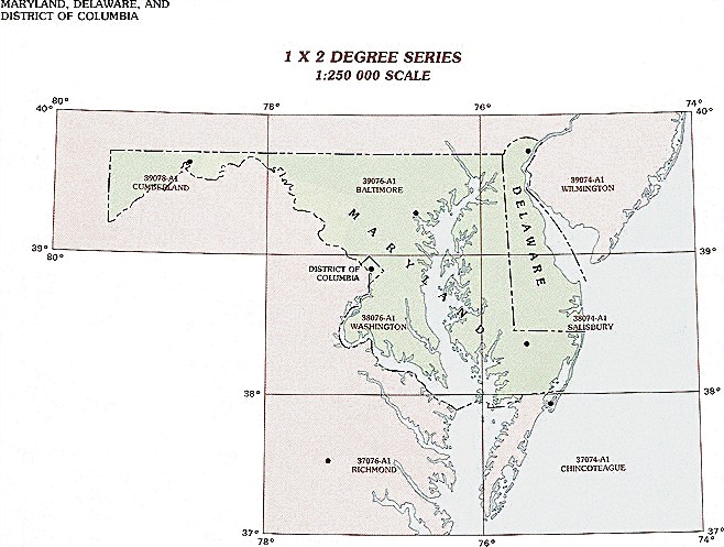
1:250,000 scale Maryland topo maps
Below you can find the 1:250,000 index map for Maryland state. These topo maps give a general overview of an area and cover a large area: 1° latitude by 2° longitude. A list of all Maryland topo map sheets at 250k follows on the right.
Maryland Topo Index Map: 1:250,000
Hover over the index map to the left to view detailed zoom.
You can also download this index map here:
Maryland topo index map at 1:250,000 Scale
250k MD topographic maps:
39078a1 Cumberland, MD
39076a1 Baltimore, MD
39074a1 Wilmington, MD
38076a1 Washington, MD
38074a1 Salisbury, MD
37076a1 Richmond, MD
37074a1 Eastville, MD
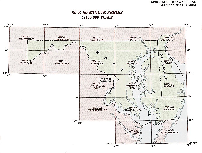
1:100,000 scale Maryland topo maps
Below you can find the 1:100,000 index map for Maryland state. These topo maps give a more detailed overview of an area and cover a medium-sized area: 0.5° latitude by 1° longitude. A list of all Maryland topo map sheets at 100k follows on the right.
Maryland Topo Index Map: 1:100,000
Hover over the index map to the left to view detailed zoom.
You can also download this index map here:
Maryland topo index map at 1:100,000 Scale
100k MD topographic maps:
39079e1 Morgantown, MD
39078e1 Cumberland, MD
39077e1 Hagerstown, MD
39076e1 York, MD
39075e1 Wilmington, MD
39079a1 Kingwood, MD
39078a1 Winchester, MD
39077a1 Frederick, MD
39076a1 Baltimore, MD
39075a1 Dover, MD
38077e1 Washington West, MD
38076e1 Washington East, MD
38075e1 Seaford, MD
38077a1 Fredericksburg, MD
38076a1 Leonardtown, MD
38075a1 Salisbury, MD
37076e1 Tappahannock, MD
37075e1 Chincoteague, MD