Kentucky topographic maps
These topographic index maps for Kentucky state are provided by the U.S. Geological Survey (USGS) for map sheet identification. To locate the USGS topo quad in Kentucky that you are trying to find, look at the index map of the appropriate map scale.
1:24,000 scale Kentucky topo quads
The index map below is for Kentucky topo quads at 1:24,000 scale. It is zoomable, and you can find the name of the 1:24,000 scale map (sometimes abbreviated as "24k") written diagonally across rectangular boxes that define the borders of the individual 24k map sheets.
Note that a rare few of the 1:24,000 scale (aka 7.5 minute) maps in Kentucky state might actually be at 1:25,000 scale, which is a very minor difference in map scale. Some of these 1:25,000 scale maps also cover a larger area than regular 7.5 minute maps. Those maps are 7.5´x15´ topo quads, and can be identified on the index map below by a larger sized rectangle that is twice as wide as usual (covers twice the longitude). The map names for these sheets are labelled horizontally, not diagonally.
Kentucky Topo Index Map: 1:24,000

Hover over the index map to the left to view detailed zoom.
You can also download this index map here:
Kentucky topo index map at 1:24,000 Scale
24k KY topographic maps:
(This is a small selection to get you started. Use the complete list of 250k or 100k maps further below to drill down to your area of choice.)
39084a7 Lawrenceburg, KY
39084a6 Burlington, KY
39084a5 Covington, KY
39084a4 Newport, KY
38084h7 Rising Sun, KY
38084h6 Union, KY
38084h5 Independence, KY
38084h4 Alexandria, KY
38084h3 New Richmond, KY
38084g6 Verona, KY
38084g5 Walton, KY
38084g4 De Mossville, KY
38084g3 Butler, KY
38085f3 Madison East, KY
38085f2 Carrollton, KY
38085f1 Vevay South, KY
38084f8 Sanders, KY
38084f7 Glencoe, KY
38084f6 Elliston, KY
38084f5 Williamstown, KY
1:250,000 scale Kentucky topo maps
Below you can find the 1:250,000 index map for Kentucky state. These topo maps give a general overview of an area and cover a large area: 1° latitude by 2° longitude. A list of all Kentucky topo map sheets at 250k follows on the right.
Kentucky Topo Index Map: 1:250,000

Hover over the index map to the left to view detailed zoom.
You can also download this index map here:
Kentucky topo index map at 1:250,000 Scale
250k KY topographic maps:
39084a1 Cincinnati, KY
38086a1 Vincennes, KY
38084a1 Louisville, KY
38082a1 Huntington, KY
37088a1 Paducah, KY
37086a1 Evansville, KY
37084a1 Winchester, KY
37082a1 Jenkins, KY
37080a1 Bluefield, KY
36088a1 Dyersburg, KY
36086a1 Nashville, KY
36084a1 Corbin, KY
36082a1 Johnson City, KY
1:100,000 scale Kentucky topo maps
Below you can find the 1:100,000 index map for Kentucky state. These topo maps give a more detailed overview of an area and cover a medium-sized area: 0.5° latitude by 1° longitude. A list of all Kentucky topo map sheets at 100k follows on the right.
Kentucky Topo Index Map: 1:100,000
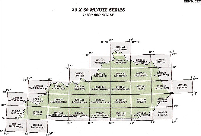
Hover over the index map to the left to view detailed zoom.
You can also download this index map here:
Kentucky topo index map at 1:100,000 Scale
100k KY topographic maps:
39084a1 Cincinnati, KY
38085e1 Madison, KY
38084e1 Falmouth, KY
38083e1 Maysville, KY
38082e1 Ironton, KY
38086a1 Jasper, KY
38085a1 Louisville, KY
38084a1 Lexington, KY
38083a1 Morehead, KY
38082a1 Huntington, KY
37088e1 West Frankfort, KY
37087e1 Evansville, KY
37086e1 Tell City, KY
37085e1 Elizabethtown, KY
37084e1 Harrodsburg, KY
37083e1 Irvine, KY
37082e1 Williamson, KY
37081e1 Beckley, KY
37089a1 Cape Girardeau, KY
37088a1 Paducah, KY
37087a1 Madisonville, KY
37086a1 Beaver Dam, KY
37085a1 Campbellsville, KY
37084a1 Somerset, KY
37083a1 Hazard, KY
37082a1 Pikeville, KY
36089e1 Sikeston, KY
36088e1 Murray, KY
36087e1 Hopkinsville, KY
36086e1 Bowling Green, KY
36085e1 Tompkinsville, KY
36084e1 Corbin, KY
36083e1 Middlesboro, KY
36082e1 Bristol, KY
36089a1 Dyersburg, KY
36088a1 Mc Kenzie, KY