Ohio topographic maps
These topographic index maps for Ohio state are provided by the U.S. Geological Survey (USGS) for map sheet identification. To locate the USGS topo quad in Ohio that you are trying to find, look at the index map of the appropriate map scale.
1:24,000 scale Ohio topo quads
The index map below is for Ohio topo quads at 1:24,000 scale. It is zoomable, and you can find the name of the 1:24,000 scale map (sometimes abbreviated as "24k") written diagonally across rectangular boxes that define the borders of the individual 24k map sheets.
Note that a rare few of the 1:24,000 scale (aka 7.5 minute) maps in Ohio state might actually be at 1:25,000 scale, which is a very minor difference in map scale. Some of these 1:25,000 scale maps also cover a larger area than regular 7.5 minute maps. Those maps are 7.5´x15´ topo quads, and can be identified on the index map below by a larger sized rectangle that is twice as wide as usual (covers twice the longitude). The map names for these sheets are labelled horizontally, not diagonally.
Ohio Topo Index Map: 1:24,000
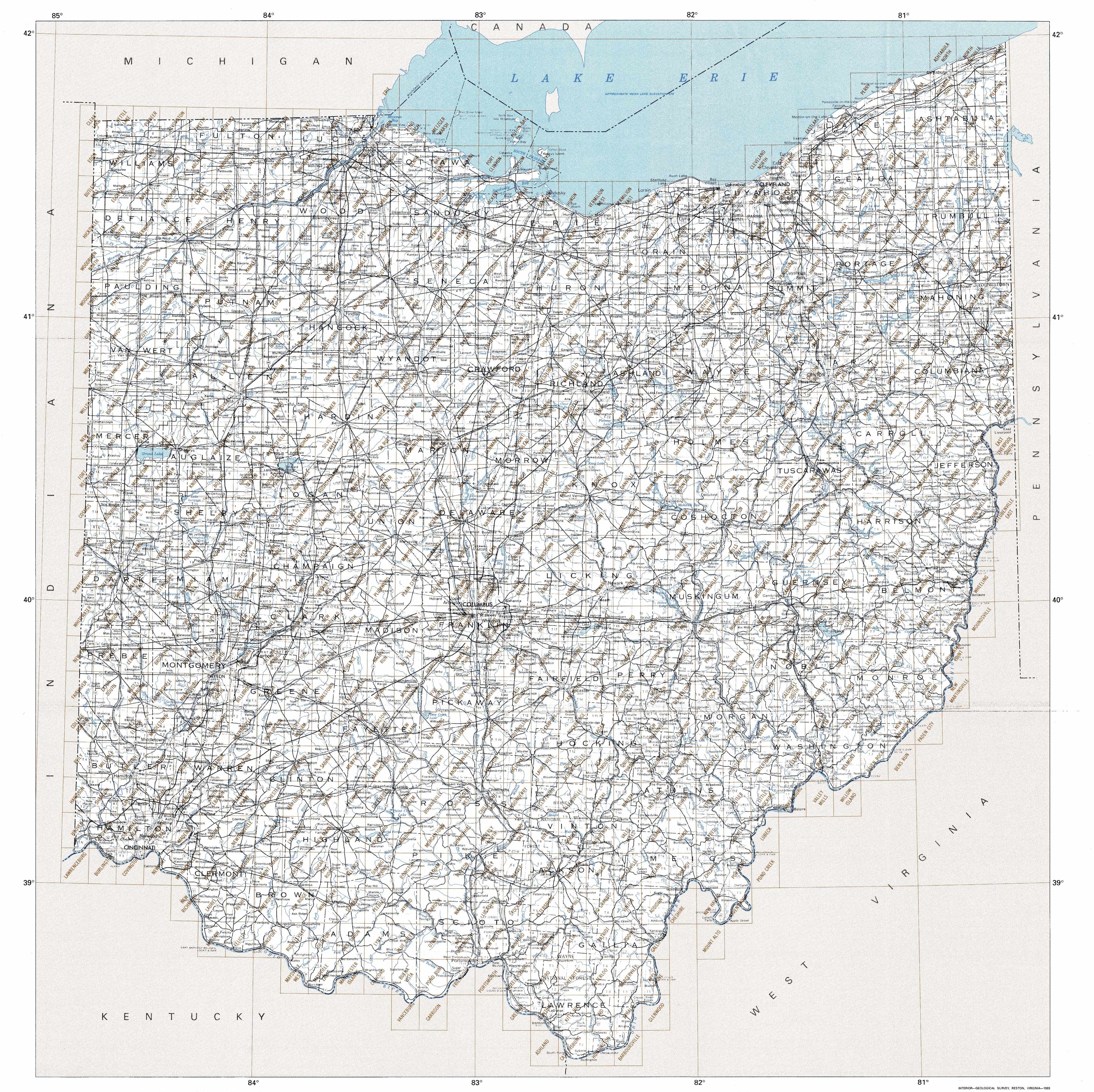
Hover over the index map to the left to view detailed zoom.
You can also download this index map here:
Ohio topo index map at 1:24,000 Scale
24k OH topographic maps:
(This is a small selection to get you started. Use the complete list of 250k or 100k maps further below to drill down to your area of choice.)
41080h7 Ashtabula North, OH
41080h6 North Kingsville, OH
41080h5 Conneaut, OH
41081g2 Perry, OH
41081g1 Madison, OH
41080g8 Geneva, OH
41080g7 Ashtabula South, OH
41080g6 Gageville, OH
41080g5 Pierpont, OH
41084f6 Nettle Lake, OH
41084f5 Pioneer, OH
41084f4 Alvordton, OH
41084f3 Fayette, OH
41084f2 Morenci, OH
41084f1 Lyons, OH
41083f8 Assumption, OH
41083f7 Berkey, OH
41083f6 Sylvania, OH
41083f5 Toledo, OH
41083f4 Oregon, OH
1:250,000 scale Ohio topo maps
Below you can find the 1:250,000 index map for Ohio state. These topo maps give a general overview of an area and cover a large area: 1° latitude by 2° longitude. A list of all Ohio topo map sheets at 250k follows on the right.
Ohio Topo Index Map: 1:250,000
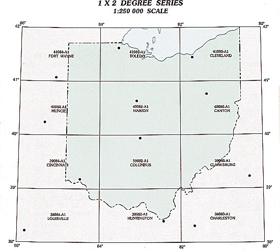
Hover over the index map to the left to view detailed zoom.
You can also download this index map here:
Ohio topo index map at 1:250,000 Scale
250k OH topographic maps:
41084a1 Ft Wayne, OH
41082a1 Toledo, OH
41080a1 Cleveland, OH
40084a1 Muncie, OH
40082a1 Marion, OH
40080a1 Canton, OH
39084a1 Cincinnati, OH
39082a1 Columbus, OH
39080a1 Clarksburg, OH
38084a1 Louisville, OH
38082a1 Huntington, OH
38080a1 Charleston, OH
1:100,000 scale Ohio topo maps
Below you can find the 1:100,000 index map for Ohio state. These topo maps give a more detailed overview of an area and cover a medium-sized area: 0.5° latitude by 1° longitude. A list of all Ohio topo map sheets at 100k follows on the right.
Ohio Topo Index Map: 1:100,000
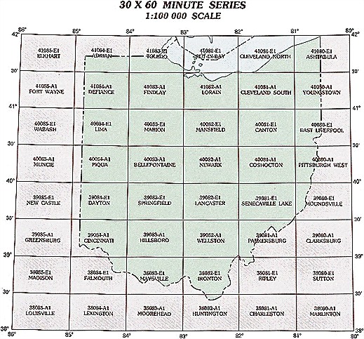
Hover over the index map to the left to view detailed zoom.
You can also download this index map here:
Ohio topo index map at 1:100,000 Scale
100k OH topographic maps:
42080a1 Erie, OH
41084e1 Adrian, OH
41083e1 Toledo, OH
41082e1 Put-In-Bay, OH
41081e1 Cleveland North, OH
41080e1 Ashtabula, OH
41084a1 Defiance, OH
41083a1 Findlay, OH
41082a1 Lorain, OH
41081a1 Cleveland South, OH
41080a1 Youngstown, OH
40084e1 Lima, OH
40083e1 Marion, OH
40082e1 Mansfield, OH
40081e1 Canton, OH
40080e1 East Liverpool, OH
40084a1 Piqua, OH
40083a1 Bellefontaine, OH
40082a1 Newark, OH
40081a1 Coshocton, OH
40080a1 Pittsburgh West, OH
39084e1 Dayton, OH
39083e1 Springfield, OH
39082e1 Lancaster, OH
39081e1 Senecaville Lake, OH
39080e1 Moundsville, OH
39084a1 Cincinnati, OH
39083a1 Hillsboro, OH
39082a1 Wellston, OH
39081a1 Parkersburg, OH
38084e1 Falmouth, OH
38083e1 Maysville, OH
38082e1 Ironton, OH
38081e1 Ripley, OH
38082a1 Huntington, OH