Wyoming topographic maps
These topographic index maps for Wyoming state are provided by the U.S. Geological Survey (USGS) for map sheet identification. To locate the USGS topo quad in Wyoming that you are trying to find, look at the index map of the appropriate map scale.
1:24,000 scale Wyoming topo quads
The index map below is for Wyoming topo quads at 1:24,000 scale. It is zoomable, and you can find the name of the 1:24,000 scale map (sometimes abbreviated as "24k") written diagonally across rectangular boxes that define the borders of the individual 24k map sheets.
Note that a rare few of the 1:24,000 scale (aka 7.5 minute) maps in Wyoming state might actually be at 1:25,000 scale, which is a very minor difference in map scale. Some of these 1:25,000 scale maps also cover a larger area than regular 7.5 minute maps. Those maps are 7.5´x15´ topo quads, and can be identified on the index map below by a larger sized rectangle that is twice as wide as usual (covers twice the longitude). The map names for these sheets are labelled horizontally, not diagonally.
Wyoming Topo Index Map: 1:24,000
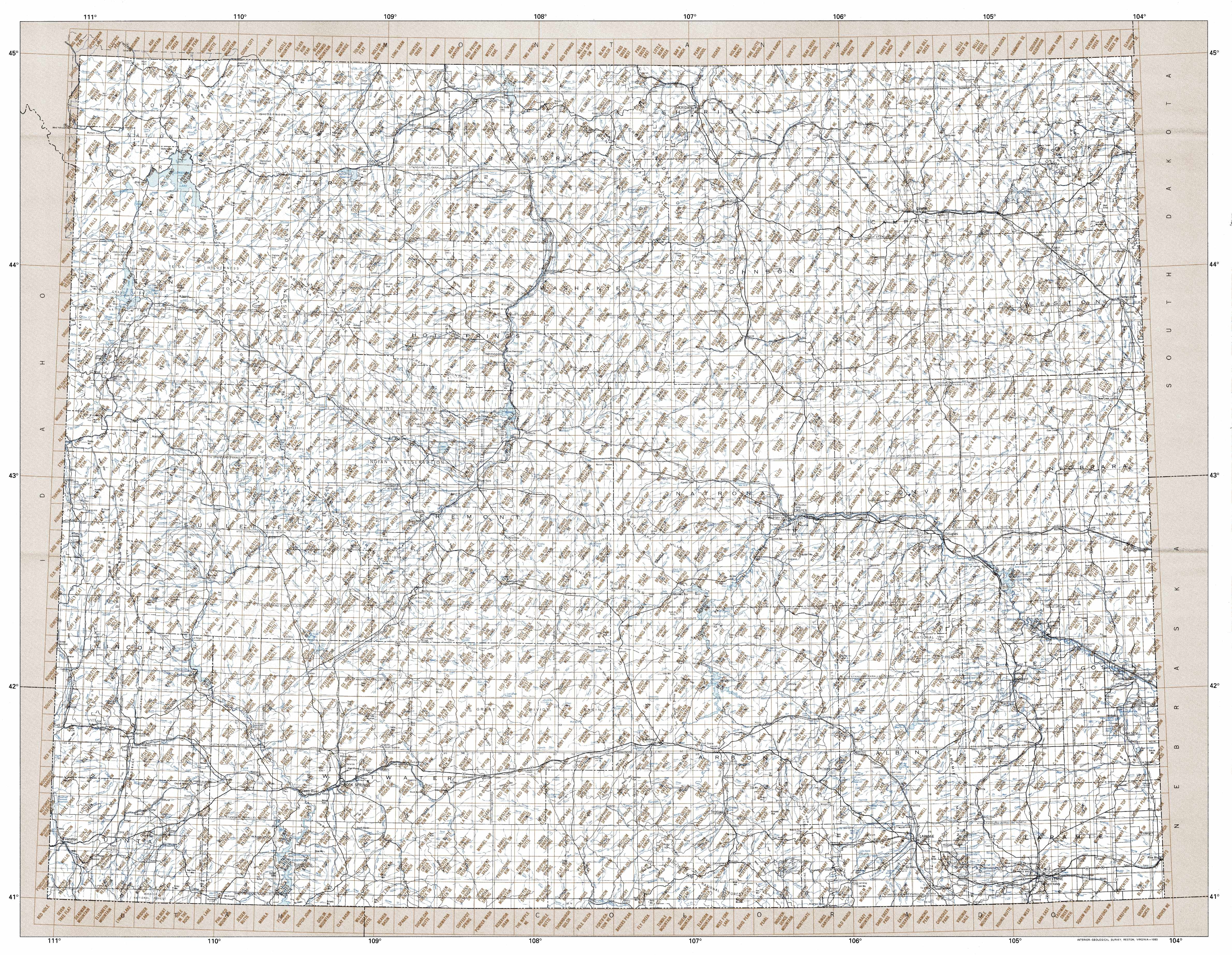
Hover over the index map to the left to view detailed zoom.
You can also download this index map here:
Wyoming topo index map at 1:24,000 Scale
24k WY topographic maps:
(This is a small selection to get you started. Use the complete list of 250k or 100k maps further below to drill down to your area of choice.)
44110h8 Joseph Peak, WY
44110h7 Quadrant Mountain, WY
44110h6 Mammoth, WY
44110h5 Blacktail Deer Creek, WY
44110h4 Tower Junction, WY
44110h3 Lamar Canyon, WY
44110h2 Mount Hornaday, WY
44110h1 Abiathar Peak, WY
44109h8 Pilot Peak, WY
44109h7 Jim Smith Peak, WY
44109h6 Muddy Creek, WY
44109h5 Beartooth Butte, WY
44109h4 Deep Lake, WY
44109h3 North Bennett Creek, WY
44109h2 Clark, WY
44109h1 Badger Basin, WY
44108h8 Elk Basin Nw, WY
44108h7 Elk Basin, WY
44108h6 Deaver Reservoir, WY
44108h5 Frannie, WY
1:250,000 scale Wyoming topo maps
Below you can find the 1:250,000 index map for Wyoming state. These topo maps give a general overview of an area and cover a large area: 1° latitude by 2° longitude. A list of all Wyoming topo map sheets at 250k follows on the right.
Wyoming Topo Index Map: 1:250,000
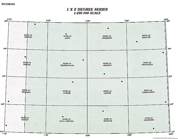
Hover over the index map to the left to view detailed zoom.
You can also download this index map here:
Wyoming topo index map at 1:250,000 Scale
250k WY topographic maps:
44110a1 Ashton, WY
44108a1 Cody, WY
44106a1 Sheridan, WY
44104a1 Gillette, WY
43110a1 Driggs, WY
43108a1 Thermopolis, WY
43106a1 Arminto, WY
43104a1 Newcastle, WY
42110a1 Preston, WY
42108a1 Lander, WY
42106a1 Casper, WY
42104a1 Torrington, WY
41110a1 Ogden, WY
41108a1 Rock Springs, WY
41106a1 Rawlins, WY
41104a1 Cheyenne, WY
1:100,000 scale Wyoming topo maps
Below you can find the 1:100,000 index map for Wyoming state. These topo maps give a more detailed overview of an area and cover a medium-sized area: 0.5° latitude by 1° longitude. A list of all Wyoming topo map sheets at 100k follows on the right.
Wyoming Topo Index Map: 1:100,000
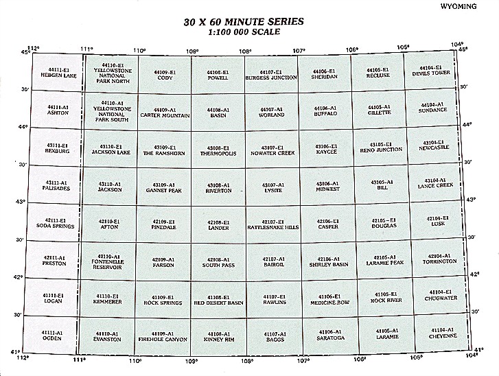
Hover over the index map to the left to view detailed zoom.
You can also download this index map here:
Wyoming topo index map at 1:100,000 Scale
100k WY topographic maps:
45111a1 Ennis, WY
45110a1 Gardiner, WY
45109a1 Red Lodge, WY
45108a1 Bridger, WY
45107a1 Lodge Grass, WY
45105a1 Broadus, WY
45104a1 Alzada, WY
44111e1 Hebgen Lake, WY
44110e1 Yellowstone National Park North, WY
44109e1 Cody, WY
44108e1 Powell, WY
44107e1 Burgess Junction, WY
44106e1 Sheridan, WY
44105e1 Recluse, WY
44104e1 Devils Tower, WY
44111a1 Ashton, WY
44110a1 Yellowstone National Park South, WY
44109a1 Carter Mountain, WY
44108a1 Basin, WY
44107a1 Worland, WY
44106a1 Buffalo, WY
44105a1 Gillette, WY
44104a1 Sundance, WY
43111e1 Rexburg, WY
43110e1 Jackson Lake, WY
43109e1 The Ramshorn, WY
43108e1 Thermopolis, WY
43107e1 Nowater Creek, WY
43106e1 Kaycee, WY
43105e1 Reno Junction, WY
43104e1 Newcastle, WY
43111a1 Palisades, WY
43110a1 Jackson, WY
43109a1 Gannett Peak, WY
43108a1 Riverton, WY
43107a1 Lysite, WY
43106a1 Midwest, WY
43105a1 Bill, WY
43104a1 Lance Creek, WY
42111e1 Soda Springs, WY
42110e1 Afton, WY
42109e1 Pinedale, WY
42108e1 Lander, WY
42107e1 Rattlesnake Hills, WY
42106e1 Casper, WY
42105e1 Douglas, WY
42104e1 Lusk, WY
42111a1 Preston, WY
42110a1 Fontenelle Reservoir, WY
42109a1 Farson, WY
42108a1 South Pass, WY
42107a1 Bairoil, WY
42106a1 Shirley Basin, WY
42105a1 Laramie Peak, WY
42104a1 Torrington, WY
41111e1 Logan, WY
41110e1 Kemmerer, WY
41109e1 Rock Springs, WY
41108e1 Red Desert Basin, WY
41107e1 Rawlins, WY
41106e1 Medicine Bow, WY
41105e1 Rock River, WY
41104e1 Chugwater, WY
41111a1 Ogden, WY
41110a1 Evanston, WY
41109a1 Firehole Canyon, WY
41108a1 Kinney Rim, WY
41107a1 Baggs, WY
41106a1 Saratoga, WY
41105a1 Laramie, WY
41104a1 Cheyenne, WY
40111e1 Salt Lake City, WY
40110e1 Kings Peak, WY
40106e1 Walden, WY
40105e1 Fort Collins, WY
40104e1 Eaton, WY