North Dakota topographic maps
These topographic index maps for North Dakota state are provided by the U.S. Geological Survey (USGS) for map sheet identification. To locate the USGS topo quad in North Dakota that you are trying to find, look at the index map of the appropriate map scale.
1:24,000 scale North Dakota topo quads
The index map below is for North Dakota topo quads at 1:24,000 scale. It is zoomable, and you can find the name of the 1:24,000 scale map (sometimes abbreviated as "24k") written diagonally across rectangular boxes that define the borders of the individual 24k map sheets.
Note that a rare few of the 1:24,000 scale (aka 7.5 minute) maps in North Dakota state might actually be at 1:25,000 scale, which is a very minor difference in map scale. Some of these 1:25,000 scale maps also cover a larger area than regular 7.5 minute maps. Those maps are 7.5´x15´ topo quads, and can be identified on the index map below by a larger sized rectangle that is twice as wide as usual (covers twice the longitude). The map names for these sheets are labelled horizontally, not diagonally.
North Dakota Topo Index Map: 1:24,000
Hover over the index map to the left to view detailed zoom.
You can also download this index map here:
North Dakota topo index map at 1:24,000 Scale
24k ND topographic maps:
(This is a small selection to get you started. Use the complete list of 250k or 100k maps further below to drill down to your area of choice.)
48103h8 Skjermo Lake, ND
48103h7 Fortuna, ND
48103h6 Colgan West, ND
48103h5 Colgan East, ND
48103h4 Ambrose, ND
48103h3 Crosby, ND
48103h2 Paulson, ND
48103h1 Noonan, ND
48102h8 Atacol, ND
48102h7 Columbus, ND
48102h6 Stampede, ND
48102h5 Portal, ND
48102h4 Flaxton, ND
48102h3 Northgate, ND
48102h2 Bowbells Nw, ND
48102h1 Bowbells Ne, ND
48101h8 Mouse River Park Nw, ND
48101h7 Mouse River Park Ne, ND
48101h6 Sherwood, ND
48101h5 Mohall Ne, ND
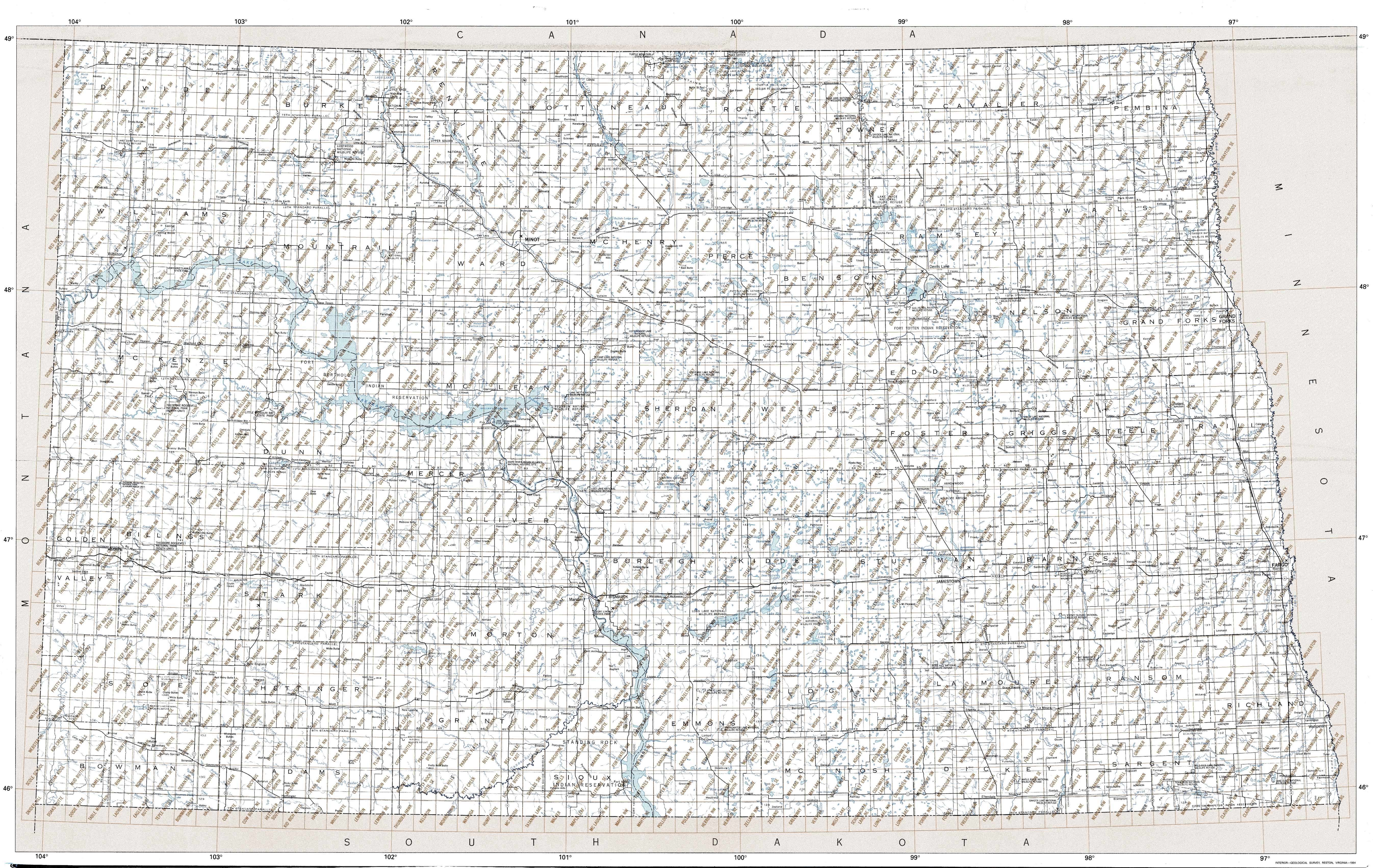
1:250,000 scale North Dakota topo maps
Below you can find the 1:250,000 index map for North Dakota state. These topo maps give a general overview of an area and cover a large area: 1° latitude by 2° longitude. A list of all North Dakota topo map sheets at 250k follows on the right.
North Dakota Topo Index Map: 1:250,000

Hover over the index map to the left to view detailed zoom.
You can also download this index map here:
North Dakota topo index map at 1:250,000 Scale
250k ND topographic maps:
48104a1 Wolf Point, ND
48102a1 Williston, ND
48100a1 Minot, ND
48098a1 Devils Lake, ND
48096a1 Thief River Falls, ND
47104a1 Glendive, ND
47102a1 Watford City, ND
47100a1 Mc Clusky, ND
47098a1 New Rockford, ND
47096a1 Grand Forks, ND
46104a1 Miles City, ND
46102a1 Dickinson, ND
46100a1 Bismarck, ND
46098a1 Jamestown, ND
46096a1 Fargo, ND
45104a1 Ekalaka, ND
45102a1 Lemmon, ND
45100a1 Mc Intosh, ND
45098a1 Aberdeen, ND
45096a1 Milbank, ND
1:100,000 scale North Dakota topo maps
Below you can find the 1:100,000 index map for North Dakota state. These topo maps give a more detailed overview of an area and cover a medium-sized area: 0.5° latitude by 1° longitude. A list of all North Dakota topo map sheets at 100k follows on the right.
North Dakota Topo Index Map: 1:100,000
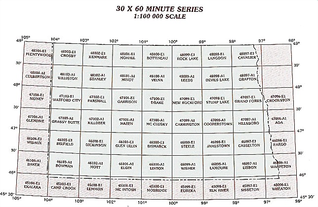
Hover over the index map to the left to view detailed zoom.
You can also download this index map here:
North Dakota topo index map at 1:100,000 Scale
100k ND topographic maps:
48104e1 Plentywood, ND
48103e1 Crosby, ND
48102e1 Kenmare, ND
48101e1 Mohall, ND
48100e1 Bottineau, ND
48099e1 Rock Lake, ND
48098e1 Langdon, ND
48097e1 Cavalier, ND
48104a1 Culbertson, ND
48103a1 Williston, ND
48102a1 Stanley, ND
48101a1 Minot, ND
48100a1 Velva, ND
48099a1 Leeds, ND
48098a1 Devils Lake, ND
48097a1 Grafton, ND
47104e1 Sidney, ND
47103e1 Watford City, ND
47102e1 Parshall, ND
47101e1 Garrison, ND
47100e1 Drake, ND
47099e1 New Rockford, ND
47098e1 Stump Lake, ND
47097e1 Grand Forks, ND
47096e1 Crookston, ND
47104a1 Glendive, ND
47103a1 Grassy Butte, ND
47102a1 Killdeer, ND
47101a1 Hazen, ND
47100a1 Mc Clusky, ND
47099a1 Carrington, ND
47098a1 Cooperstown, ND
47097a1 Hillsboro, ND
47096a1 Ada, ND
46104e1 Wibaux, ND
46103e1 Belfield, ND
46102e1 Dickinson, ND
46101e1 Glen Ullin, ND
46100e1 Bismarck, ND
46099e1 Steele, ND
46098e1 Jamestown, ND
46097e1 Casselton, ND
46096e1 Fargo, ND
46104a1 Baker, ND
46103a1 Bowman, ND
46102a1 Mott, ND
46101a1 Elgin, ND
46100a1 Linton, ND
46099a1 Wishek, ND
46098a1 Lamoure, ND
46097a1 Lisbon, ND
46096a1 Wahpeton, ND
45104e1 Ekalaka, ND
45103e1 Camp Crook, ND
45102e1 Lemmon, ND
45101e1 Mc Intosh, ND
45100e1 Mobridge, ND
45099e1 Eureka, ND
45098e1 Elm River, ND
45097e1 Sisseton, ND
45096e1 Wheaton, ND