Arkansas topographic maps
These topographic index maps for Arkansas state are provided by the U.S. Geological Survey (USGS) for map sheet identification. To locate the USGS topo quad in Arkansas that you are trying to find, look at the index map of the appropriate map scale.
1:24,000 scale Arkansas topo quads
The index map below is for Arkansas topo quads at 1:24,000 scale. It is zoomable, and you can find the name of the 1:24,000 scale map (sometimes abbreviated as "24k") written diagonally across rectangular boxes that define the borders of the individual 24k map sheets.
Note that a rare few of the 1:24,000 scale (aka 7.5 minute) maps in Arkansas state might actually be at 1:25,000 scale, which is a very minor difference in map scale. Some of these 1:25,000 scale maps also cover a larger area than regular 7.5 minute maps. Those maps are 7.5´x15´ topo quads, and can be identified on the index map below by a larger sized rectangle that is twice as wide as usual (covers twice the longitude). The map names for these sheets are labelled horizontally, not diagonally.
Arkansas Topo Index Map: 1:24,000
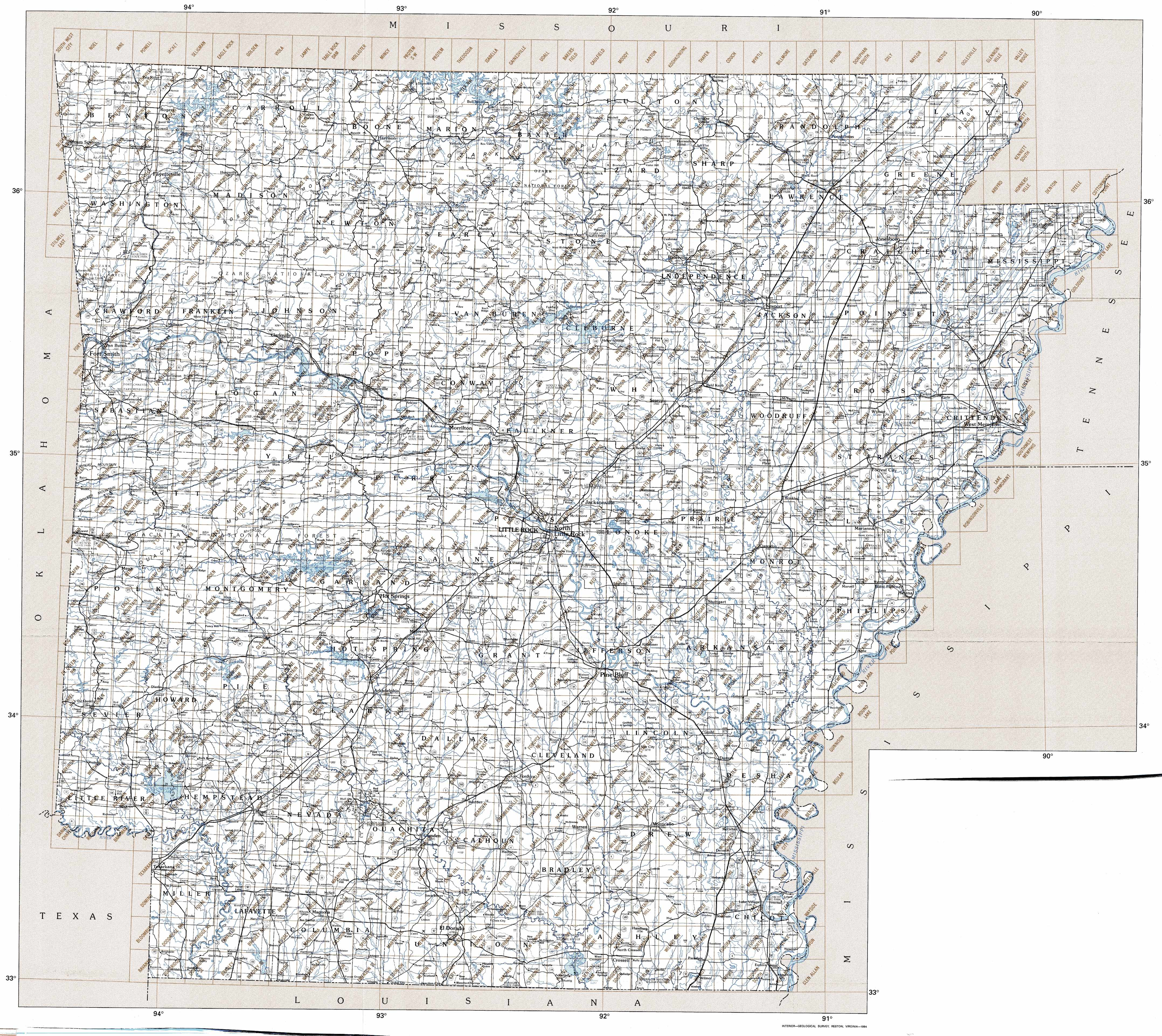
Hover over the index map to the left to view detailed zoom.
You can also download this index map here:
Arkansas topo index map at 1:24,000 Scale
24k AR topographic maps:
(This is a small selection to get you started. Use the complete list of 250k or 100k maps further below to drill down to your area of choice.)
36094d5 Colcord Ne, AR
36094d4 Gravette, AR
36094d3 Hiwasse, AR
36094d2 Bentonville North, AR
36094d1 Pea Ridge, AR
36093d8 Garfield, AR
36093d7 Beaver, AR
36093d6 Eureka Springs, AR
36093d5 Grandview, AR
36093d4 Blue Eye, AR
36093d3 Denver, AR
36093d2 Omaha, AR
36093d1 Omaha Ne, AR
36092d8 Diamond City, AR
36092d7 Peel, AR
36092d6 Cotter Nw, AR
36092d5 Bull Shoals, AR
36092d4 Midway, AR
36092d3 Clarkridge, AR
36092d2 Gamaliel, AR
1:250,000 scale Arkansas topo maps
Below you can find the 1:250,000 index map for Arkansas state. These topo maps give a general overview of an area and cover a large area: 1° latitude by 2° longitude. A list of all Arkansas topo map sheets at 250k follows on the right.
Arkansas Topo Index Map: 1:250,000
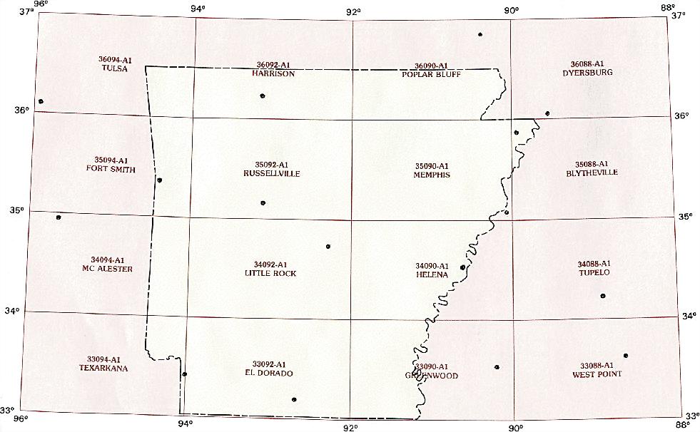
Hover over the index map to the left to view detailed zoom.
You can also download this index map here:
Arkansas topo index map at 1:250,000 Scale
250k AR topographic maps:
36094a1 Tulsa, AR
36092a1 Harrison, AR
36090a1 Poplar Bluff, AR
35094a1 Ft Smith, AR
35092a1 Russelville, AR
35090a1 Memphis, AR
35088a1 Blytheville, AR
34094a1 Mc Alester, AR
34092a1 Little Rock, AR
34090a1 Helena, AR
33094a1 Texarkana, AR
33092a1 El Dorado, AR
33090a1 Greenwood, AR
1:100,000 scale Arkansas topo maps
Below you can find the 1:100,000 index map for Arkansas state. These topo maps give a more detailed overview of an area and cover a medium-sized area: 0.5° latitude by 1° longitude. A list of all Arkansas topo map sheets at 100k follows on the right.
Arkansas Topo Index Map: 1:100,000
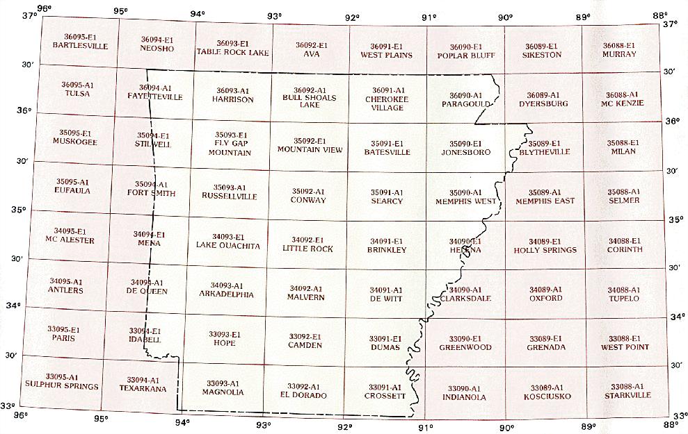
Hover over the index map to the left to view detailed zoom.
You can also download this index map here:
Arkansas topo index map at 1:100,000 Scale
100k AR topographic maps:
36094a1 Fayetteville, AR
36093a1 Harrison, AR
36092a1 Bull Shoals Lake, AR
36091a1 Cherokee Village, AR
36090a1 Paragould, AR
36089a1 Dyersburg, AR
35094e1 Stilwell, AR
35093e1 Fly Gap Mountain, AR
35092e1 Mountain View, AR
35091e1 Batesville, AR
35090e1 Jonesboro, AR
35089e1 Blytheville, AR
35094a1 Fort Smith, AR
35093a1 Russellville, AR
35092a1 Conway, AR
35091a1 Searcy, AR
35090a1 Memphis West, AR
34094e1 Mena, AR
34093e1 Lake Ouachita, AR
34092e1 Little Rock, AR
34091e1 Brinkley, AR
34090e1 Helena, AR
34094a1 De Queen, AR
34093a1 Arkadelphia, AR
34092a1 Malvern, AR
34091a1 De Witt, AR
34090a1 Clarksdale, AR
33094e1 Idabel, AR
33093e1 Hope, AR
33092e1 Camden, AR
33091e1 Dumas, AR
33090e1 Greenwood, AR
33094a1 Texarkana, AR
33093a1 Magnolia, AR
33092a1 El Dorado, AR
33091a1 Crossett, AR