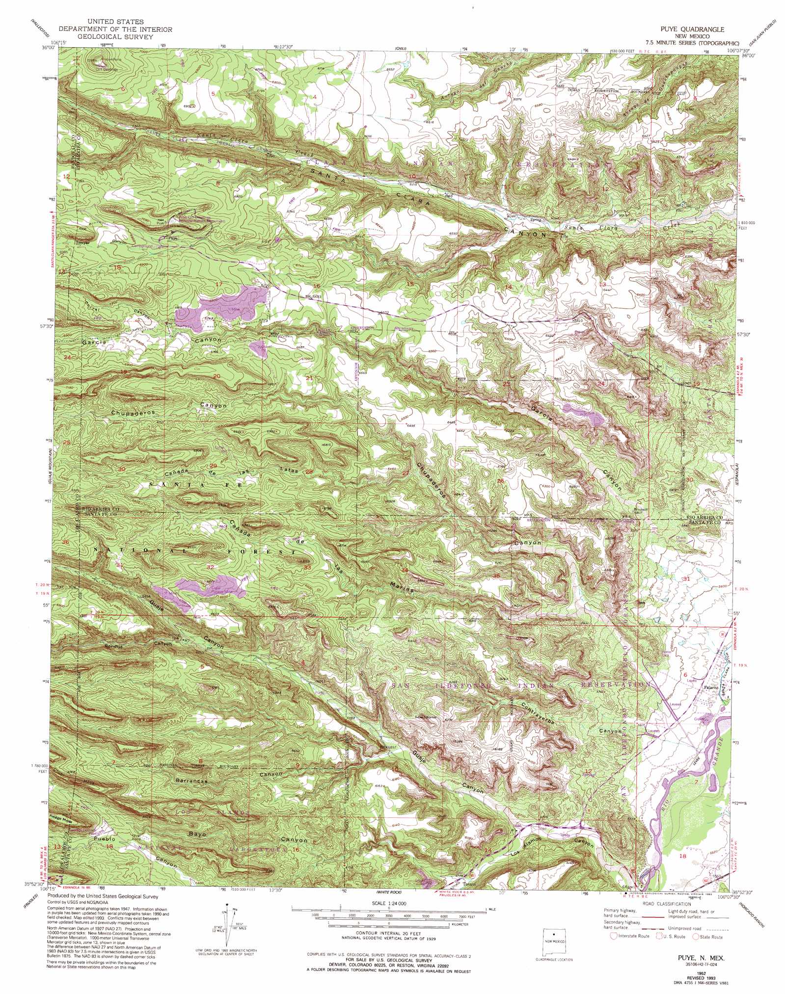
Puye Topo Map New Mexico
To zoom in, hover over the map of Puye
USGS Topo Quad 35106h2 - 1:24,000 scale
| Topo Map Name: | Puye |
| USGS Topo Quad ID: | 35106h2 |
| Print Size: | ca. 21 1/4" wide x 27" high |
| Southeast Coordinates: | 35.875° N latitude / 106.125° W longitude |
| Map Center Coordinates: | 35.9375° N latitude / 106.1875° W longitude |
| U.S. State: | NM |
| Filename: | o35106h2.jpg |
| Download Map JPG Image: | Puye topo map 1:24,000 scale |
| Map Type: | Topographic |
| Topo Series: | 7.5´ |
| Map Scale: | 1:24,000 |
| Source of Map Images: | United States Geological Survey (USGS) |
| Alternate Map Versions: |
Puye NM 1952, updated 1954 Download PDF Buy paper map Puye NM 1952, updated 1963 Download PDF Buy paper map Puye NM 1952, updated 1979 Download PDF Buy paper map Puye NM 1952, updated 1993 Download PDF Buy paper map Puye NM 2002, updated 2003 Download PDF Buy paper map Puye NM 2011 Download PDF Buy paper map Puye NM 2013 Download PDF Buy paper map Puye NM 2017 Download PDF Buy paper map |
| FStopo: | US Forest Service topo Puye is available: Download FStopo PDF Download FStopo TIF |
1:24,000 Topo Quads surrounding Puye
Canones |
Abiquiu |
Medanales |
Lyden |
Velarde |
Polvadera Peak |
Vallecitos |
Chili |
San Juan Pueblo |
Chimayo |
Valle Toledo |
Guaje Mountain |
Puye |
Espanola |
Cundiyo |
Bland |
Frijoles |
White Rock |
Horcado Ranch |
Tesuque |
Canada |
Cochiti Dam |
Montoso Peak |
Agua Fria |
Santa Fe |
> Back to 35106e1 at 1:100,000 scale
> Back to 35106a1 at 1:250,000 scale
> Back to U.S. Topo Maps home
Puye topo map: Gazetteer
Puye: Arches
Popawi elevation 2124m 6968′Puye: Mines
Copar Mine elevation 2087m 6847′Copar Pumice Mine elevation 2026m 6646′
General Pumice Mine elevation 2057m 6748′
Santa Clara Pumice Pit 3 elevation 2062m 6765′
White Eagle Pumice Mine elevation 1989m 6525′
White Eagle Pumice Mine elevation 1992m 6535′
White Eagle Pumice Mine elevation 1898m 6227′
Puye: Parks
Puye Ruins Historical Marker elevation 2092m 6863′Puye: Populated Places
Otowi elevation 1681m 5515′Pajarito elevation 1684m 5524′
Puye elevation 2092m 6863′
Totavi elevation 1762m 5780′
Puye: Post Offices
Otowi Post Office (historical) elevation 1681m 5515′Puye: Reservoirs
Guaye Trick Tank elevation 2035m 6676′Puye: Valleys
Barrancas Canyon elevation 1792m 5879′Bayo Canyon elevation 1761m 5777′
Cañada de las Latas elevation 1900m 6233′
Cañada de las Marias elevation 1769m 5803′
Chupaderos Canyon elevation 1721m 5646′
Contrayerba Canyon elevation 1696m 5564′
Corral Canyon elevation 2054m 6738′
Garcia Canyon elevation 1699m 5574′
Guaje Canyon elevation 1730m 5675′
Los Alamos Canyon elevation 1675m 5495′
Rendija Canyon elevation 1899m 6230′
Sawyer Canyon elevation 2078m 6817′
Puye: Wells
10159 Water Well elevation 1688m 5538′Guaje 1 Water Well elevation 1824m 5984′
Guaje 1-A Water Well elevation 1832m 6010′
Guaje 2 Water Well elevation 1849m 6066′
Guaje 3 Water Well elevation 1871m 6138′
Guaje 4 Well elevation 1902m 6240′
Guaje 5 Water Well elevation 1930m 6332′
LA 6 Water Well elevation 1765m 5790′
Los Alamos 1B Water Well elevation 1716m 5629′
Los Alamos 3 Water Well elevation 1732m 5682′
RC-17901 Water Well elevation 1680m 5511′
Test 3 Water Well elevation 1713m 5620′
Puye digital topo map on disk
Buy this Puye topo map showing relief, roads, GPS coordinates and other geographical features, as a high-resolution digital map file on DVD: