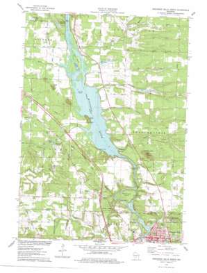
Wisconsin Dells North Topo Map Wisconsin
To zoom in, hover over the map of Wisconsin Dells North
USGS Topo Quad 43089f7 - 1:24,000 scale
| Topo Map Name: | Wisconsin Dells North |
| USGS Topo Quad ID: | 43089f7 |
| Print Size: | ca. 21 1/4" wide x 27" high |
| Southeast Coordinates: | 43.625° N latitude / 89.75° W longitude |
| Map Center Coordinates: | 43.6875° N latitude / 89.8125° W longitude |
| U.S. State: | WI |
| Filename: | o43089f7.jpg |
| Download Map JPG Image: | Wisconsin Dells North topo map 1:24,000 scale |
| Map Type: | Topographic |
| Topo Series: | 7.5´ |
| Map Scale: | 1:24,000 |
| Source of Map Images: | United States Geological Survey (USGS) |
| Alternate Map Versions: |
Wisconsin Dells NE WI 1975, updated 1976 Download PDF Buy paper map Wisconsin Dells North WI 1975, updated 1978 Download PDF Buy paper map Wisconsin Dells North WI 2010 Download PDF Buy paper map Wisconsin Dells North WI 2013 Download PDF Buy paper map Wisconsin Dells North WI 2016 Download PDF Buy paper map |
1:24,000 Topo Quads surrounding Wisconsin Dells North
> Back to 43089e1 at 1:100,000 scale
> Back to 43088a1 at 1:250,000 scale
> Back to U.S. Topo Maps home
Wisconsin Dells North topo map: Gazetteer
Wisconsin Dells North: Airports
Grogan Heliport elevation 272m 892′Wisconsin Dells North: Capes
Fox Point elevation 278m 912′Wisconsin Dells North: Cliffs
Louie Bluff elevation 273m 895′Rogge Bluff elevation 284m 931′
Swandas Bluff elevation 281m 921′
Wisconsin Dells North: Dams
Fawn Lake 3WR1011 Dam elevation 263m 862′Kilbourn Dam elevation 246m 807′
Trout Lake Dam elevation 263m 862′
Wisconsin Dells North: Gaps
The Narrows elevation 253m 830′Wisconsin Dells North: Islands
Blackhawk Island elevation 284m 931′Clark Island elevation 255m 836′
Dutchman Islands elevation 254m 833′
Wisconsin Dells North: Lakes
Lake Lee elevation 258m 846′Wisconsin Dells North: Parks
Blackhawk Island State Natural Area elevation 283m 928′Hulbert Creek Woods State Natural Area elevation 265m 869′
Rocky Arbor State Park elevation 289m 948′
Wisconsin Dells North: Pillars
Stand Rock elevation 278m 912′Steamboat Rock elevation 257m 843′
Wisconsin Dells North: Populated Places
Plainville elevation 263m 862′Wisconsin Dells elevation 277m 908′
Wisconsin Dells North: Post Offices
Wisconsin Dells Post Office elevation 276m 905′Wisconsin Dells North: Reservoirs
Crandalls Bay elevation 254m 833′Fawn Lake elevation 263m 862′
Fawn Lake 2.2 elevation 265m 869′
Kilbourn Flowage 7746 elevation 246m 807′
Trout Lake elevation 263m 862′
Trout Lake 4 elevation 264m 866′
Wisconsin Dells North: Ridges
Elephants Back elevation 316m 1036′Wisconsin Dells North: Streams
Corning Creek elevation 256m 839′Gilmore Creek elevation 254m 833′
Gulch Creek elevation 261m 856′
Lyndon Creek elevation 254m 833′
Plainville Creek elevation 254m 833′
Shadduck Creek elevation 255m 836′
Trout Creek elevation 258m 846′
Wisconsin Dells North: Valleys
Artist Glen elevation 253m 830′Coldwater Canyon elevation 253m 830′
Roodes Glen elevation 259m 849′
The Dells elevation 287m 941′
Upper Dells elevation 262m 859′
Witches Gulch elevation 254m 833′
Wisconsin Dells North digital topo map on disk
Buy this Wisconsin Dells North topo map showing relief, roads, GPS coordinates and other geographical features, as a high-resolution digital map file on DVD:


