Kitty Creek Topo Map Montana
To zoom in, hover over the map of Kitty Creek
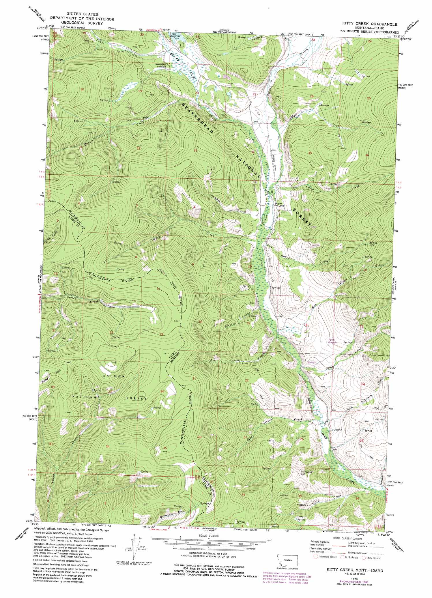
USGS Topo Quad 45113a4 - 1:24,000 scale
| Topo Map Name: | Kitty Creek |
| USGS Topo Quad ID: | 45113a4 |
| Print Size: | ca. 21 1/4" wide x 27" high |
| Southeast Coordinates: | 45° N latitude / 113.375° W longitude |
| Map Center Coordinates: | 45.0625° N latitude / 113.4375° W longitude |
| U.S. States: | MT, ID |
| Filename: | o45113a4.jpg |
| Download Map JPG Image: | Kitty Creek topo map 1:24,000 scale |
| Map Type: | Topographic |
| Topo Series: | 7.5´ |
| Map Scale: | 1:24,000 |
| Source of Map Images: | United States Geological Survey (USGS) |
| Alternate Map Versions: |
Kitty Creek MT 1978, updated 1979 Download PDF Buy paper map Kitty Creek MT 1978, updated 1989 Download PDF Buy paper map Kitty Creek MT 1997, updated 2002 Download PDF Buy paper map Kitty Creek MT 2011 Download PDF Buy paper map Kitty Creek MT 2014 Download PDF Buy paper map |
| FStopo: | US Forest Service topo Kitty Creek is available: Download FStopo PDF Download FStopo TIF |
1:24,000 Topo Quads surrounding Kitty Creek
Homer Youngs Peak |
Miner Lake |
Jackson |
Butch Hill |
Tash Peak |
Bohannon Spring |
Goldstone Pass |
Selway Mountain |
Peterson Lake |
Brays Canyon |
Baker |
Goldstone Mountain |
Kitty Creek |
Coyote Creek |
Bachelor Mountain |
Tendoy |
Agency Creek |
Lemhi Pass |
Everson Creek |
Jeff Davis Peak |
Hayden Creek |
Lemhi |
Goat Mountain |
Bannock Pass |
Deadman Pass |
> Back to 45113a1 at 1:100,000 scale
> Back to 45112a1 at 1:250,000 scale
> Back to U.S. Topo Maps home
Kitty Creek topo map: Gazetteer
Kitty Creek: Mines
Kelly Creek Mine elevation 2211m 7253′Kitty Creek: Reservoirs
Reservoir Lake elevation 2157m 7076′Kitty Creek: Streams
Brenneis Creek elevation 2037m 6683′Camp Creek elevation 2059m 6755′
Dutch Creek elevation 2018m 6620′
East Creek elevation 2071m 6794′
East Peterson Creek elevation 2000m 6561′
East Terrell Creek elevation 2061m 6761′
Eunice Creek elevation 2138m 7014′
Hopps Creek elevation 2047m 6715′
Kelly Creek elevation 1977m 6486′
Kitty Creek elevation 2069m 6788′
Lake Creek elevation 2152m 7060′
Mooney Creek elevation 2133m 6998′
Selway Creek elevation 2098m 6883′
West Peterson Creek elevation 2000m 6561′
West Terrell Creek elevation 2026m 6646′
Kitty Creek: Summits
Pyramid Hill elevation 2325m 7627′Kitty Creek: Trails
Pattee Ridge Trail elevation 2631m 8631′Kitty Creek: Valleys
Hamilton Gulch elevation 1980m 6496′Hughes Gulch elevation 2072m 6797′
Kitty Creek digital topo map on disk
Buy this Kitty Creek topo map showing relief, roads, GPS coordinates and other geographical features, as a high-resolution digital map file on DVD: