Goldstone Mountain Topo Map Idaho
To zoom in, hover over the map of Goldstone Mountain
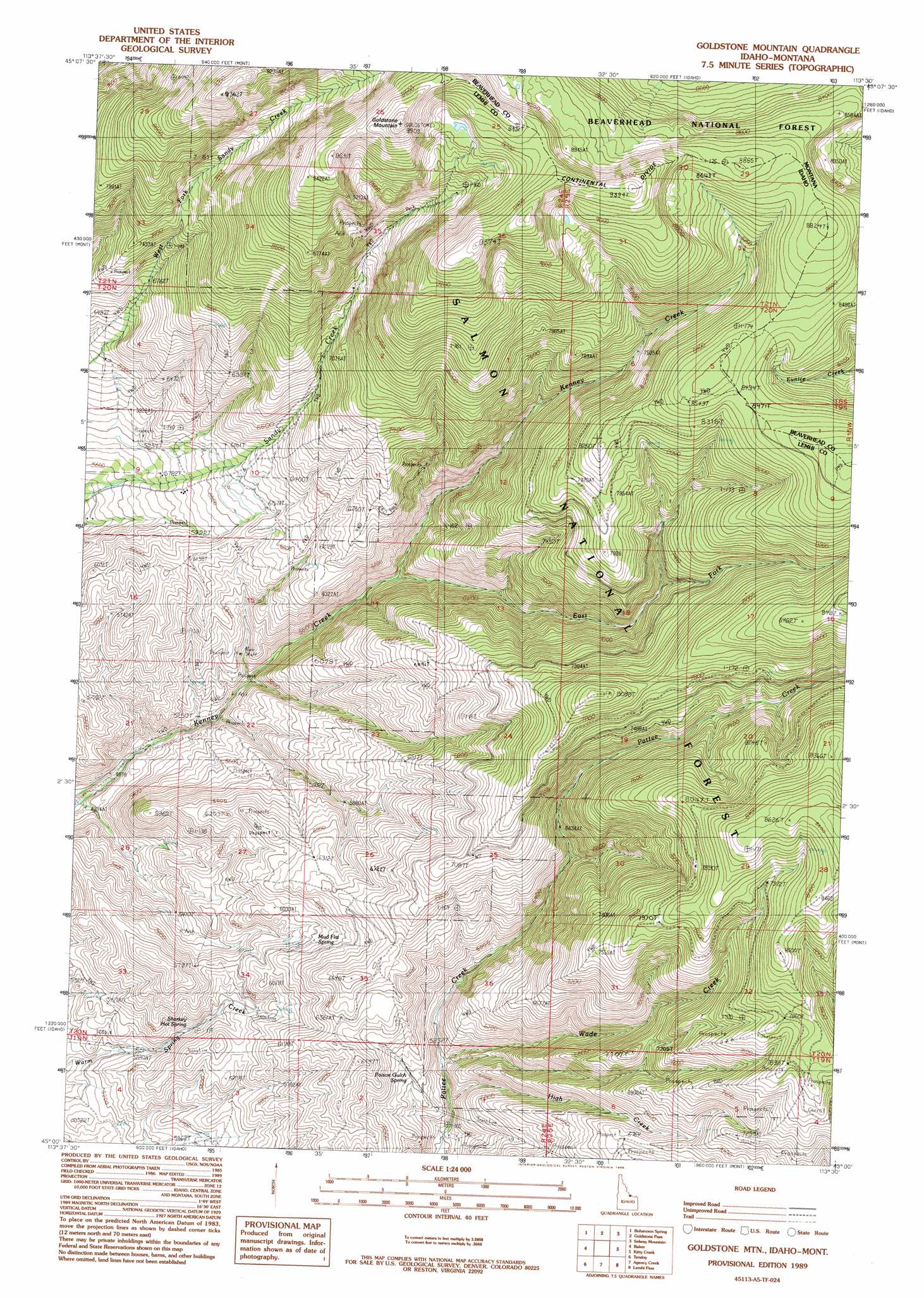
USGS Topo Quad 45113a5 - 1:24,000 scale
| Topo Map Name: | Goldstone Mountain |
| USGS Topo Quad ID: | 45113a5 |
| Print Size: | ca. 21 1/4" wide x 27" high |
| Southeast Coordinates: | 45° N latitude / 113.5° W longitude |
| Map Center Coordinates: | 45.0625° N latitude / 113.5625° W longitude |
| U.S. States: | ID, MT |
| Filename: | o45113a5.jpg |
| Download Map JPG Image: | Goldstone Mountain topo map 1:24,000 scale |
| Map Type: | Topographic |
| Topo Series: | 7.5´ |
| Map Scale: | 1:24,000 |
| Source of Map Images: | United States Geological Survey (USGS) |
| Alternate Map Versions: |
Goldstone Mtn ID 1989, updated 1989 Download PDF Buy paper map Goldstone Mountain ID 1997, updated 2002 Download PDF Buy paper map Goldstone Mountain ID 2011 Download PDF Buy paper map Goldstone Mountain ID 2013 Download PDF Buy paper map |
| FStopo: | US Forest Service topo Goldstone Mountain is available: Download FStopo PDF Download FStopo TIF |
1:24,000 Topo Quads surrounding Goldstone Mountain
Badger Spring Gulch |
Homer Youngs Peak |
Miner Lake |
Jackson |
Butch Hill |
East Of Salmon |
Bohannon Spring |
Goldstone Pass |
Selway Mountain |
Peterson Lake |
Sal Mountain |
Baker |
Goldstone Mountain |
Kitty Creek |
Coyote Creek |
Poison Peak |
Tendoy |
Agency Creek |
Lemhi Pass |
Everson Creek |
Lem Peak |
Hayden Creek |
Lemhi |
Goat Mountain |
Bannock Pass |
> Back to 45113a1 at 1:100,000 scale
> Back to 45112a1 at 1:250,000 scale
> Back to U.S. Topo Maps home
Goldstone Mountain topo map: Gazetteer
Goldstone Mountain: Springs
Mud Flat Spring elevation 1834m 6017′Poison Gulch Spring elevation 1771m 5810′
Sharkey Hot Spring elevation 1653m 5423′
Goldstone Mountain: Streams
East Fork Kenney Creek elevation 1732m 5682′High Creek elevation 1682m 5518′
Wade Creek elevation 1687m 5534′
Goldstone Mountain: Summits
Goldstone Mountain elevation 3009m 9872′Goldstone Mountain digital topo map on disk
Buy this Goldstone Mountain topo map showing relief, roads, GPS coordinates and other geographical features, as a high-resolution digital map file on DVD: