Selway Mountain Topo Map Montana
To zoom in, hover over the map of Selway Mountain
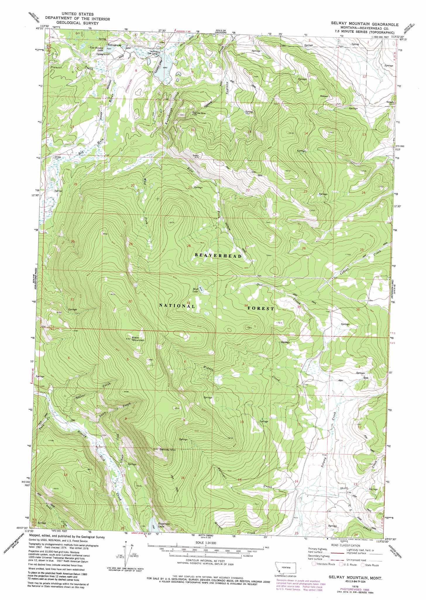
USGS Topo Quad 45113b4 - 1:24,000 scale
| Topo Map Name: | Selway Mountain |
| USGS Topo Quad ID: | 45113b4 |
| Print Size: | ca. 21 1/4" wide x 27" high |
| Southeast Coordinates: | 45.125° N latitude / 113.375° W longitude |
| Map Center Coordinates: | 45.1875° N latitude / 113.4375° W longitude |
| U.S. State: | MT |
| Filename: | o45113b4.jpg |
| Download Map JPG Image: | Selway Mountain topo map 1:24,000 scale |
| Map Type: | Topographic |
| Topo Series: | 7.5´ |
| Map Scale: | 1:24,000 |
| Source of Map Images: | United States Geological Survey (USGS) |
| Alternate Map Versions: |
Selway Mountain MT 1978, updated 1989 Download PDF Buy paper map Selway Mountain MT 2011 Download PDF Buy paper map Selway Mountain MT 2014 Download PDF Buy paper map |
| FStopo: | US Forest Service topo Selway Mountain is available: Download FStopo PDF Download FStopo TIF |
1:24,000 Topo Quads surrounding Selway Mountain
Jumbo Mountain |
Ajax Ranch |
Fox Gulch |
Jackson Hill |
Maverick Mountain |
Homer Youngs Peak |
Miner Lake |
Jackson |
Butch Hill |
Tash Peak |
Bohannon Spring |
Goldstone Pass |
Selway Mountain |
Peterson Lake |
Brays Canyon |
Baker |
Goldstone Mountain |
Kitty Creek |
Coyote Creek |
Bachelor Mountain |
Tendoy |
Agency Creek |
Lemhi Pass |
Everson Creek |
Jeff Davis Peak |
> Back to 45113a1 at 1:100,000 scale
> Back to 45112a1 at 1:250,000 scale
> Back to U.S. Topo Maps home
Selway Mountain topo map: Gazetteer
Selway Mountain: Dams
Lazy Jackson Dam elevation 2247m 7372′Reservoir Lake Dam elevation 2155m 7070′
Selway Mountain: Flats
Dunkwaden Flats elevation 2190m 7185′Selway Mountain: Lakes
Mud Lake elevation 2461m 8074′Van Houten Lake elevation 2141m 7024′
Selway Mountain: Mines
Saginaw Mine elevation 2227m 7306′Saginaw Mine elevation 2244m 7362′
Selway Mountain: Reservoirs
Reservoir Lake elevation 2155m 7070′Selway Mountain: Springs
07S15W07AADD01 Spring elevation 2145m 7037′Selway Mountain: Streams
C L Creek elevation 2168m 7112′Dean Creek elevation 2192m 7191′
East Fork Englebaugh Creek elevation 2206m 7237′
Englebaugh Creek elevation 2132m 6994′
Hidden Creek elevation 2194m 7198′
Jahnke Creek elevation 2183m 7162′
Ore Creek elevation 2211m 7253′
Park Creek elevation 2214m 7263′
Pioneer Creek elevation 2147m 7043′
Short Creek elevation 2169m 7116′
Stover Creek elevation 2210m 7250′
Surveyor Creek elevation 2168m 7112′
U-Turn Creek elevation 2183m 7162′
West Fork Englebaugh Creek elevation 2207m 7240′
Selway Mountain: Summits
Black Mountain elevation 2797m 9176′Selway Mountain elevation 2712m 8897′
Selway Mountain: Swamps
Dunkwaden Flats elevation 2168m 7112′Selway Mountain: Wells
07S15W08BBBC01 Well elevation 2146m 7040′Selway Mountain digital topo map on disk
Buy this Selway Mountain topo map showing relief, roads, GPS coordinates and other geographical features, as a high-resolution digital map file on DVD: