Goldstone Pass Topo Map Montana
To zoom in, hover over the map of Goldstone Pass
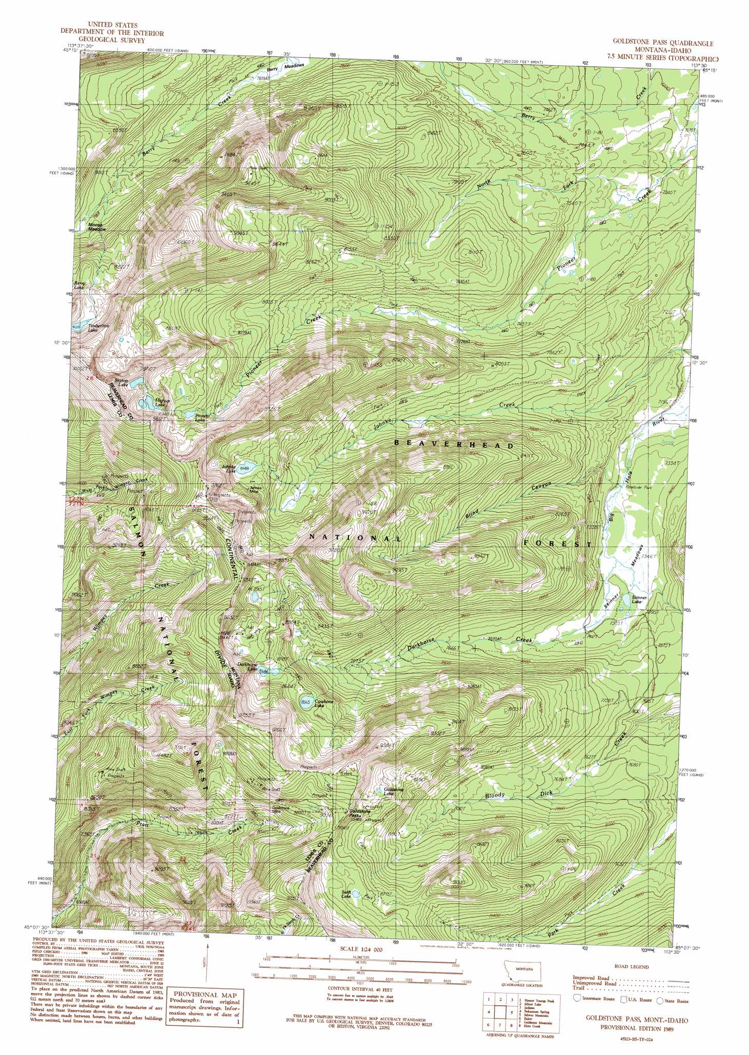
USGS Topo Quad 45113b5 - 1:24,000 scale
| Topo Map Name: | Goldstone Pass |
| USGS Topo Quad ID: | 45113b5 |
| Print Size: | ca. 21 1/4" wide x 27" high |
| Southeast Coordinates: | 45.125° N latitude / 113.5° W longitude |
| Map Center Coordinates: | 45.1875° N latitude / 113.5625° W longitude |
| U.S. States: | MT, ID |
| Filename: | o45113b5.jpg |
| Download Map JPG Image: | Goldstone Pass topo map 1:24,000 scale |
| Map Type: | Topographic |
| Topo Series: | 7.5´ |
| Map Scale: | 1:24,000 |
| Source of Map Images: | United States Geological Survey (USGS) |
| Alternate Map Versions: |
Goldstone Pass MT 1989, updated 1989 Download PDF Buy paper map Goldstone Pass MT 1997, updated 2002 Download PDF Buy paper map Goldstone Pass MT 2011 Download PDF Buy paper map Goldstone Pass MT 2014 Download PDF Buy paper map |
| FStopo: | US Forest Service topo Goldstone Pass is available: Download FStopo PDF Download FStopo TIF |
1:24,000 Topo Quads surrounding Goldstone Pass
Shewag Lake |
Jumbo Mountain |
Ajax Ranch |
Fox Gulch |
Jackson Hill |
Badger Spring Gulch |
Homer Youngs Peak |
Miner Lake |
Jackson |
Butch Hill |
East Of Salmon |
Bohannon Spring |
Goldstone Pass |
Selway Mountain |
Peterson Lake |
Sal Mountain |
Baker |
Goldstone Mountain |
Kitty Creek |
Coyote Creek |
Poison Peak |
Tendoy |
Agency Creek |
Lemhi Pass |
Everson Creek |
> Back to 45113a1 at 1:100,000 scale
> Back to 45112a1 at 1:250,000 scale
> Back to U.S. Topo Maps home
Goldstone Pass topo map: Gazetteer
Goldstone Pass: Flats
Berry Meadows elevation 2324m 7624′Moose Meadow elevation 2483m 8146′
Skinner Meadows elevation 2244m 7362′
Goldstone Pass: Gaps
Goldstone Pass elevation 2774m 9101′Goldstone Pass elevation 2760m 9055′
Goldstone Pass: Lakes
Alpine Lake elevation 2622m 8602′Cowbone Lake elevation 2612m 8569′
Darkhorse Lake elevation 2650m 8694′
Goldstone Lake elevation 2701m 8861′
Highup Lake elevation 2804m 9199′
Janhke Lake elevation 2650m 8694′
Pioneer Lake elevation 2663m 8736′
Skinner Lake elevation 2246m 7368′
Skytop Lake elevation 2793m 9163′
Swift Lake elevation 2702m 8864′
Timberline Lake elevation 2784m 9133′
Goldstone Pass: Mines
Copper Queen Mine elevation 2854m 9363′Goldstone Mine elevation 2638m 8654′
HRS Claim Mine elevation 2811m 9222′
Jahnke Mine elevation 2659m 8723′
Jahnke Mine elevation 2665m 8743′
Goldstone Pass: Streams
Berry Creek elevation 2180m 7152′Darkhorse Creek elevation 2239m 7345′
North Fork Pioneer Creek elevation 2208m 7244′
Goldstone Pass: Valleys
Blind Canyon elevation 2219m 7280′Goldstone Pass digital topo map on disk
Buy this Goldstone Pass topo map showing relief, roads, GPS coordinates and other geographical features, as a high-resolution digital map file on DVD: