Tahquamenon Lakes Topo Map Michigan
To zoom in, hover over the map of Tahquamenon Lakes
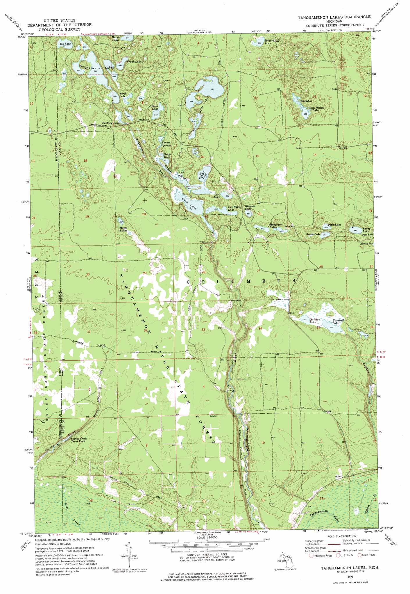
USGS Topo Quad 46085d7 - 1:24,000 scale
| Topo Map Name: | Tahquamenon Lakes |
| USGS Topo Quad ID: | 46085d7 |
| Print Size: | ca. 21 1/4" wide x 27" high |
| Southeast Coordinates: | 46.375° N latitude / 85.75° W longitude |
| Map Center Coordinates: | 46.4375° N latitude / 85.8125° W longitude |
| U.S. State: | MI |
| Filename: | o46085d7.jpg |
| Download Map JPG Image: | Tahquamenon Lakes topo map 1:24,000 scale |
| Map Type: | Topographic |
| Topo Series: | 7.5´ |
| Map Scale: | 1:24,000 |
| Source of Map Images: | United States Geological Survey (USGS) |
| Alternate Map Versions: |
Tahquamenon Lakes MI 1972, updated 1975 Download PDF Buy paper map Tahquamenon Lakes MI 2011 Download PDF Buy paper map Tahquamenon Lakes MI 2014 Download PDF Buy paper map Tahquamenon Lakes MI 2017 Download PDF Buy paper map |
1:24,000 Topo Quads surrounding Tahquamenon Lakes
Grand Sable Lake |
Grand Marais |
Grand Marais Ne |
Muskallonge Lake West |
Muskallonge Lake East |
Au Sable Point Se |
Nawakwa Lake |
Grand Marais Se |
Muskallonge Lake Sw |
Muskallonge Lake Se |
Sunken Lake |
Seney Nw |
Tahquamenon Lakes |
Buckeye Lake |
Auger Lake |
Driggs Lake Se |
Seney |
Hardwood Island |
Mcmillan |
Newberry |
Marsh Creek Pool |
Germfask |
Curtis West |
Curtis East |
Millecoquins |
> Back to 46085a1 at 1:100,000 scale
> Back to 46084a1 at 1:250,000 scale
> Back to U.S. Topo Maps home
Tahquamenon Lakes topo map: Gazetteer
Tahquamenon Lakes: Lakes
Bear Lake elevation 276m 905′Belle Lakes elevation 270m 885′
Bennet Springs elevation 262m 859′
Benny Lake elevation 263m 862′
Camp Seven Alke elevation 261m 856′
Devils Hollow Lake elevation 274m 898′
Dishpan Lake elevation 261m 856′
Frank Lake elevation 271m 889′
Fur Farm Lake elevation 259m 849′
Grass Lake elevation 261m 856′
Grass Slough elevation 261m 856′
Hanes Lake elevation 268m 879′
Long Lake elevation 258m 846′
Lost Lake elevation 263m 862′
Minard Lake elevation 275m 902′
Moose Lakes elevation 264m 866′
Musgrave Lakes elevation 259m 849′
Perch Lake elevation 268m 879′
Peter Lake elevation 265m 869′
Quinlan Lake elevation 261m 856′
Smith Lake elevation 264m 866′
Spring Creek Trout Pond elevation 236m 774′
Tahquamenon Lakes elevation 268m 879′
Tek Lake elevation 275m 902′
Turnbull Lake elevation 259m 849′
Whitney Lake elevation 267m 875′
Tahquamenon Lakes digital topo map on disk
Buy this Tahquamenon Lakes topo map showing relief, roads, GPS coordinates and other geographical features, as a high-resolution digital map file on DVD: