Rudie Coulee Topo Map Montana
To zoom in, hover over the map of Rudie Coulee
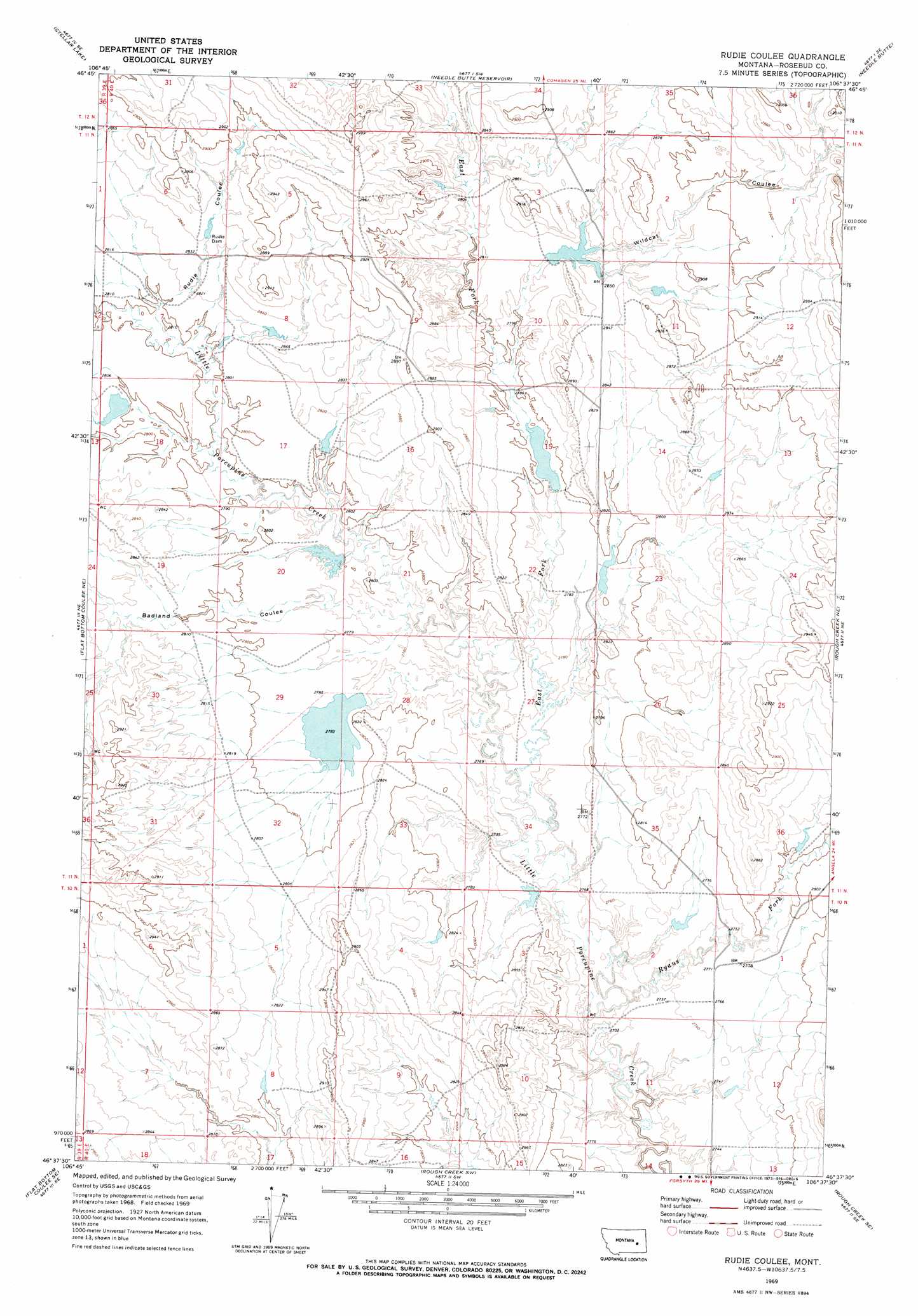
USGS Topo Quad 46106f6 - 1:24,000 scale
| Topo Map Name: | Rudie Coulee |
| USGS Topo Quad ID: | 46106f6 |
| Print Size: | ca. 21 1/4" wide x 27" high |
| Southeast Coordinates: | 46.625° N latitude / 106.625° W longitude |
| Map Center Coordinates: | 46.6875° N latitude / 106.6875° W longitude |
| U.S. State: | MT |
| Filename: | o46106f6.jpg |
| Download Map JPG Image: | Rudie Coulee topo map 1:24,000 scale |
| Map Type: | Topographic |
| Topo Series: | 7.5´ |
| Map Scale: | 1:24,000 |
| Source of Map Images: | United States Geological Survey (USGS) |
| Alternate Map Versions: |
Rudie Coulee MT 1969, updated 1973 Download PDF Buy paper map Rudie Coulee MT 2011 Download PDF Buy paper map Rudie Coulee MT 2014 Download PDF Buy paper map |
1:24,000 Topo Quads surrounding Rudie Coulee
Mother Butte |
Antelope Springs |
Black Hills |
Christenson Reservoir |
Hillside |
Vanstel |
Stellar Lake |
Needle Butte Reservoir |
Needle Butte |
Clear Water Reservoir |
Flat Bottom Coulee Nw |
Flat Bottom Coulee Ne |
Rudie Coulee |
Rough Creek Ne |
Van Burton Creek |
Flat Bottom Coulee Sw |
Flat Bottom Coulee Se |
Rough Creek Sw |
Rough Creek Se |
Wild Horse Pass |
Donleys Reservoir |
Finch Ne |
Black Coulee |
Schultz Coulee |
Box Canyon Coulee |
> Back to 46106e1 at 1:100,000 scale
> Back to 46106a1 at 1:250,000 scale
> Back to U.S. Topo Maps home
Rudie Coulee topo map: Gazetteer
Rudie Coulee: Dams
Hanson Company Number 5 Dam elevation 854m 2801′Rudie Dam elevation 867m 2844′
Standish Number 1 Dam elevation 847m 2778′
Standish Number 3 Dam elevation 837m 2746′
Three Forks Dam elevation 862m 2828′
Trout Dam elevation 879m 2883′
Ulmer Lake Dam elevation 848m 2782′
US Number 3 Dam elevation 856m 2808′
VT Number 1 Dam elevation 849m 2785′
Wildcat Reservoir Dam elevation 918m 3011′
Rudie Coulee: Streams
East Fork Little Porcupine Creek elevation 836m 2742′Ryans Fork elevation 835m 2739′
Rudie Coulee: Valleys
Badland Coulee elevation 847m 2778′Rudie Coulee elevation 854m 2801′
Wildcat Coulee elevation 854m 2801′
Rudie Coulee digital topo map on disk
Buy this Rudie Coulee topo map showing relief, roads, GPS coordinates and other geographical features, as a high-resolution digital map file on DVD:
Eastern Montana & Western North Dakota
Buy digital topo maps: Eastern Montana & Western North Dakota