Flat Bottom Coulee Ne Topo Map Montana
To zoom in, hover over the map of Flat Bottom Coulee Ne
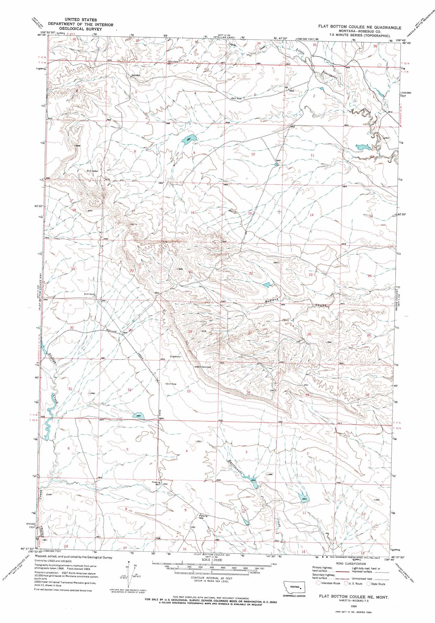
USGS Topo Quad 46106f7 - 1:24,000 scale
| Topo Map Name: | Flat Bottom Coulee Ne |
| USGS Topo Quad ID: | 46106f7 |
| Print Size: | ca. 21 1/4" wide x 27" high |
| Southeast Coordinates: | 46.625° N latitude / 106.75° W longitude |
| Map Center Coordinates: | 46.6875° N latitude / 106.8125° W longitude |
| U.S. State: | MT |
| Filename: | o46106f7.jpg |
| Download Map JPG Image: | Flat Bottom Coulee Ne topo map 1:24,000 scale |
| Map Type: | Topographic |
| Topo Series: | 7.5´ |
| Map Scale: | 1:24,000 |
| Source of Map Images: | United States Geological Survey (USGS) |
| Alternate Map Versions: |
Flat Bottom Coulee NE MT 1969, updated 1973 Download PDF Buy paper map Flat Bottom Coulee NE MT 2011 Download PDF Buy paper map Flat Bottom Coulee NE MT 2014 Download PDF Buy paper map |
1:24,000 Topo Quads surrounding Flat Bottom Coulee Ne
Kramer Ranch |
Mother Butte |
Antelope Springs |
Black Hills |
Christenson Reservoir |
Acorn Flats |
Vanstel |
Stellar Lake |
Needle Butte Reservoir |
Needle Butte |
Brown Coulee |
Flat Bottom Coulee Nw |
Flat Bottom Coulee Ne |
Rudie Coulee |
Rough Creek Ne |
Zempel Lake |
Flat Bottom Coulee Sw |
Flat Bottom Coulee Se |
Rough Creek Sw |
Rough Creek Se |
Vananda |
Donleys Reservoir |
Finch Ne |
Black Coulee |
Schultz Coulee |
> Back to 46106e1 at 1:100,000 scale
> Back to 46106a1 at 1:250,000 scale
> Back to U.S. Topo Maps home
Flat Bottom Coulee Ne topo map: Gazetteer
Flat Bottom Coulee Ne: Dams
Hanson Company Number 11 Dam elevation 878m 2880′Hanson Company Number 12 Dam elevation 855m 2805′
US Number 16 Dam elevation 879m 2883′
Whaley Number 11 Dam elevation 876m 2874′
Whaley Number 13 Dam elevation 868m 2847′
Flat Bottom Coulee Ne: Streams
Coyote Creek elevation 865m 2837′Flat Bottom Coulee Ne digital topo map on disk
Buy this Flat Bottom Coulee Ne topo map showing relief, roads, GPS coordinates and other geographical features, as a high-resolution digital map file on DVD:
Eastern Montana & Western North Dakota
Buy digital topo maps: Eastern Montana & Western North Dakota