Jordan Topo Map Montana
To zoom in, hover over the map of Jordan
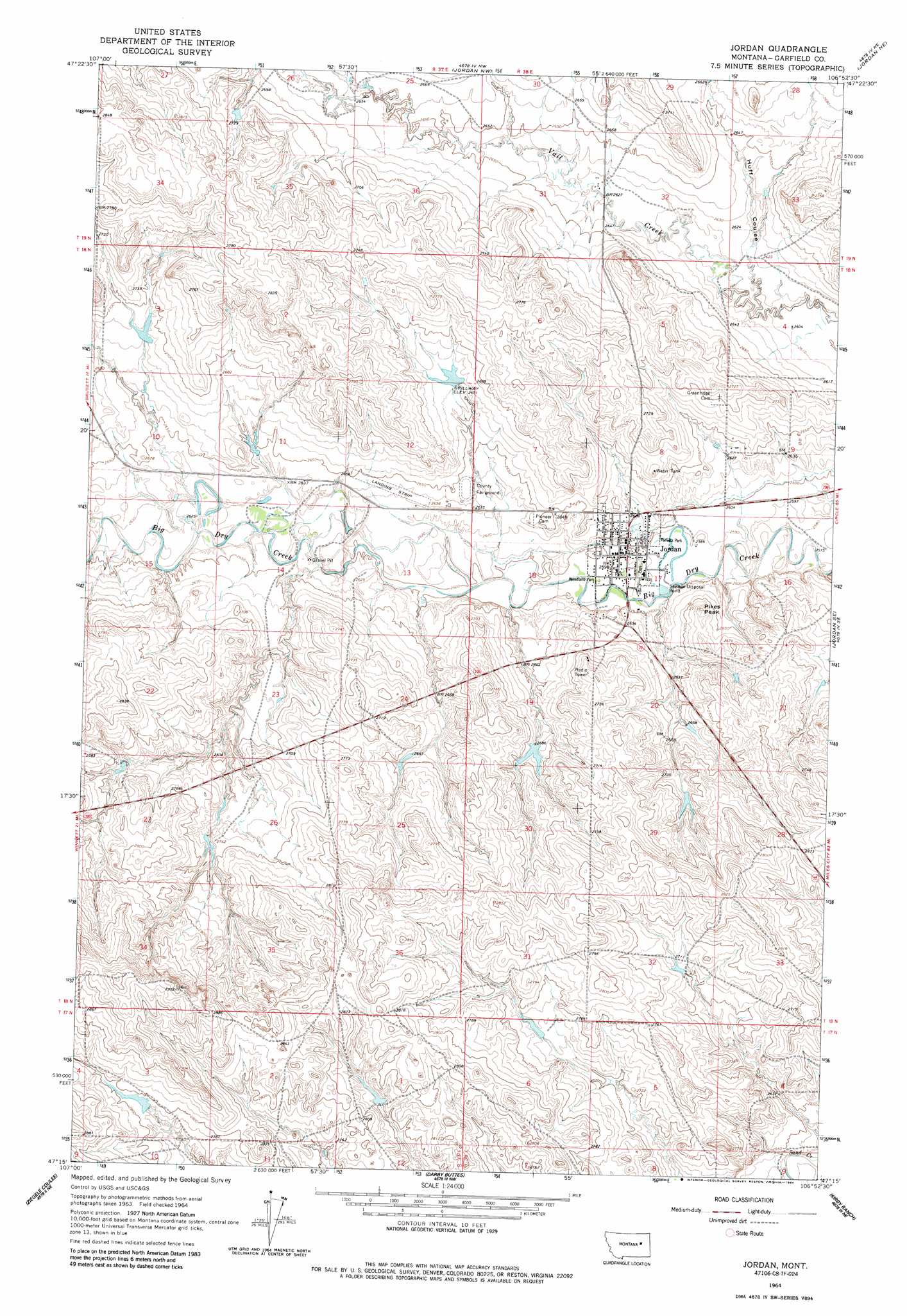
USGS Topo Quad 47106c8 - 1:24,000 scale
| Topo Map Name: | Jordan |
| USGS Topo Quad ID: | 47106c8 |
| Print Size: | ca. 21 1/4" wide x 27" high |
| Southeast Coordinates: | 47.25° N latitude / 106.875° W longitude |
| Map Center Coordinates: | 47.3125° N latitude / 106.9375° W longitude |
| U.S. State: | MT |
| Filename: | o47106c8.jpg |
| Download Map JPG Image: | Jordan topo map 1:24,000 scale |
| Map Type: | Topographic |
| Topo Series: | 7.5´ |
| Map Scale: | 1:24,000 |
| Source of Map Images: | United States Geological Survey (USGS) |
| Alternate Map Versions: |
Jordan MT 1964, updated 1967 Download PDF Buy paper map Jordan MT 1964, updated 1984 Download PDF Buy paper map Jordan MT 2011 Download PDF Buy paper map Jordan MT 2014 Download PDF Buy paper map |
1:24,000 Topo Quads surrounding Jordan
Hell Hollow |
Trumbo Ranch |
Maloney Hill |
Buffalo Hill |
Kester School |
Moonlight Creek |
Biscuit Butte |
Jordan Nw |
Jordan Ne |
Bateman Coulee |
Smoky Butte Creek |
Smoky Butte |
Jordan |
Jordan Se |
Black John Coulee |
Big Dry School |
Ziegele |
Darby Buttes |
Kirby Ranch |
York Reservoir |
Van Dusen Spring |
Fig Mountain |
Darby Buttes Sw |
Dice Dam |
Cohagen Sw |
> Back to 47106a1 at 1:100,000 scale
> Back to 47106a1 at 1:250,000 scale
> Back to U.S. Topo Maps home
Jordan topo map: Gazetteer
Jordan: Airports
Jordan Airport elevation 810m 2657′Jordan: Dams
Coleman Number 1 Dam elevation 819m 2687′Happy Jack Number 1 Dam elevation 853m 2798′
John Boy Number 2 Dam elevation 818m 2683′
Mister PP Dam elevation 815m 2673′
Jordan: Parks
Indian Country Historical Marker elevation 803m 2634′Kariotis Park elevation 792m 2598′
Panwitz Park elevation 790m 2591′
Willems Park elevation 790m 2591′
Woodland Park elevation 791m 2595′
Jordan: Populated Places
Jordan elevation 793m 2601′Jordan: Post Offices
Jordan Post Office elevation 794m 2604′Jordan: Summits
Pikes Peak elevation 823m 2700′Jordan: Valleys
Huff Coulee elevation 797m 2614′Jordan: Wells
18N38E17B___01 Well elevation 799m 2621′18N38E17B___02 Well elevation 795m 2608′
18N38E18AACC01 Well elevation 798m 2618′
18N38E20BBAB01 Well elevation 812m 2664′
19N38E31A___01 Well elevation 802m 2631′
Jordan digital topo map on disk
Buy this Jordan topo map showing relief, roads, GPS coordinates and other geographical features, as a high-resolution digital map file on DVD:
Eastern Montana & Western North Dakota
Buy digital topo maps: Eastern Montana & Western North Dakota