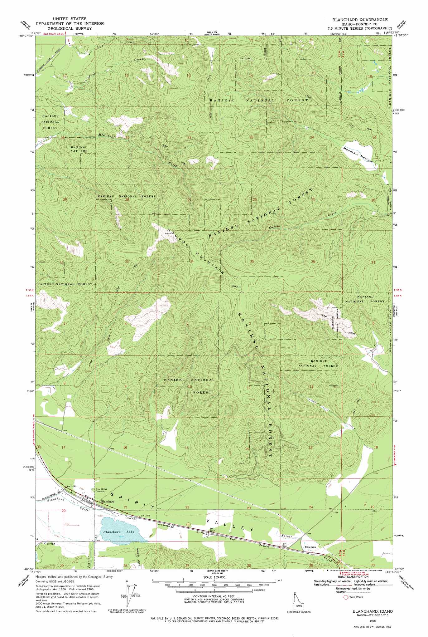
Blanchard Topo Map Idaho
To zoom in, hover over the map of Blanchard
USGS Topo Quad 48116a8 - 1:24,000 scale
| Topo Map Name: | Blanchard |
| USGS Topo Quad ID: | 48116a8 |
| Print Size: | ca. 21 1/4" wide x 27" high |
| Southeast Coordinates: | 48° N latitude / 116.875° W longitude |
| Map Center Coordinates: | 48.0625° N latitude / 116.9375° W longitude |
| U.S. State: | ID |
| Filename: | o48116a8.jpg |
| Download Map JPG Image: | Blanchard topo map 1:24,000 scale |
| Map Type: | Topographic |
| Topo Series: | 7.5´ |
| Map Scale: | 1:24,000 |
| Source of Map Images: | United States Geological Survey (USGS) |
| Alternate Map Versions: |
Blanchard ID 1968, updated 1971 Download PDF Buy paper map Blanchard ID 1968, updated 1978 Download PDF Buy paper map Blanchard ID 1996, updated 1999 Download PDF Buy paper map Blanchard ID 2011 Download PDF Buy paper map Blanchard ID 2013 Download PDF Buy paper map |
| FStopo: | US Forest Service topo Blanchard is available: Download FStopo PDF Download FStopo TIF |
1:24,000 Topo Quads surrounding Blanchard
Skookum Creek |
Bead Lake |
Quartz Mountain |
Prater Mountain |
Happy Fork Gap |
Diamond Lake |
Newport |
Priest River |
Laclede |
Morton |
Camden |
Tweedie |
Blanchard |
Edgemere |
Careywood |
Mount Kit Carson |
Mount Spokane |
Spirit Lake West |
Spirit Lake East |
Athol |
Foothills |
Newman Lake |
Rathdrum |
Hayden |
Hayden Lake |
> Back to 48116a1 at 1:100,000 scale
> Back to 48116a1 at 1:250,000 scale
> Back to U.S. Topo Maps home
Blanchard topo map: Gazetteer
Blanchard: Flats
Mountain Meadow elevation 900m 2952′Blanchard: Lakes
Blanchard Lake elevation 687m 2253′Blanchard: Populated Places
Blanchard elevation 697m 2286′Coleman elevation 701m 2299′
Blanchard: Streams
Blanchard Creek elevation 688m 2257′Fish Creek elevation 701m 2299′
Poirier Creek elevation 691m 2267′
Spirit Creek elevation 695m 2280′
Blanchard: Summits
Hoodoo Mountain elevation 1552m 5091′Blanchard: Valleys
Melder Draw elevation 696m 2283′Spirit Valley elevation 697m 2286′
Blanchard digital topo map on disk
Buy this Blanchard topo map showing relief, roads, GPS coordinates and other geographical features, as a high-resolution digital map file on DVD: