Cascilla Topo Map Mississippi
To zoom in, hover over the map of Cascilla
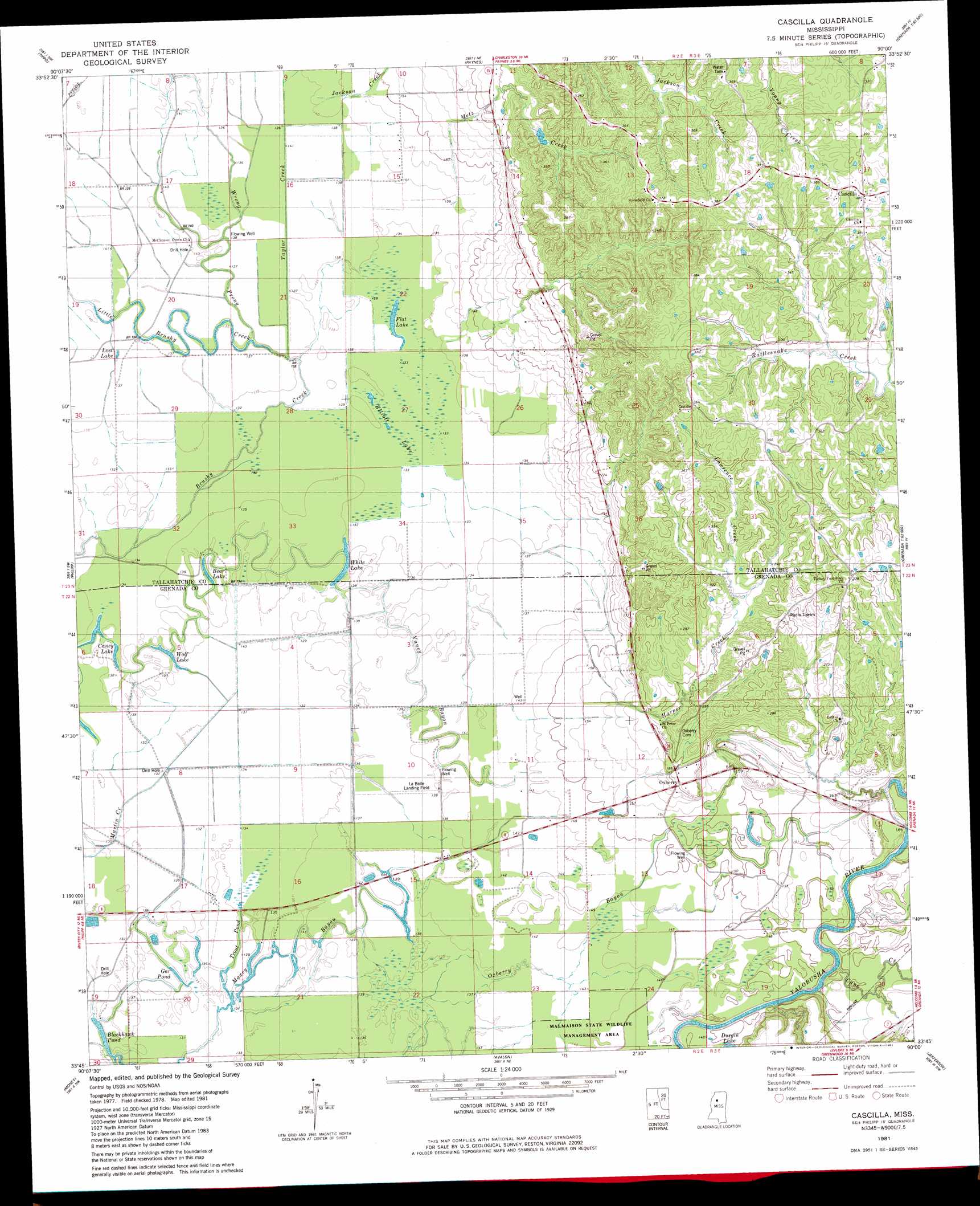
USGS Topo Quad 33090g1 - 1:24,000 scale
| Topo Map Name: | Cascilla |
| USGS Topo Quad ID: | 33090g1 |
| Print Size: | ca. 21 1/4" wide x 27" high |
| Southeast Coordinates: | 33.75° N latitude / 90° W longitude |
| Map Center Coordinates: | 33.8125° N latitude / 90.0625° W longitude |
| U.S. State: | MS |
| Filename: | o33090g1.jpg |
| Download Map JPG Image: | Cascilla topo map 1:24,000 scale |
| Map Type: | Topographic |
| Topo Series: | 7.5´ |
| Map Scale: | 1:24,000 |
| Source of Map Images: | United States Geological Survey (USGS) |
| Alternate Map Versions: |
Philipp SE MS 1974, updated 1975 Download PDF Buy paper map Cascilla MS 1981, updated 1982 Download PDF Buy paper map Cascilla MS 2012 Download PDF Buy paper map Cascilla MS 2015 Download PDF Buy paper map |
1:24,000 Topo Quads surrounding Cascilla
Vance |
Fishhook Lake |
Charleston |
Oakland |
Coker Lake |
Webb |
Tippo |
Paynes |
Tillatoba |
Scobey |
Glendora |
Philipp |
Cascilla |
Holcomb |
Grenada |
Schlater |
Money |
Avalon |
Jefferson |
Tie Plant |
Shellmound |
Greenwood |
Browning |
North Carrollton |
Mccarley |
> Back to 33090e1 at 1:100,000 scale
> Back to 33090a1 at 1:250,000 scale
> Back to U.S. Topo Maps home
Cascilla topo map: Gazetteer
Cascilla: Crossings
Chocchuma Ferry (historical) elevation 42m 137′Cascilla: Dams
Ascalmore Creek Y-17a-75 Dam elevation 69m 226′Cascilla: Guts
Maxey Bayou elevation 39m 127′Vaney Bayou elevation 41m 134′
Cascilla: Lakes
Bear Lake elevation 41m 134′Blackhawk Pond elevation 38m 124′
Caney Lake elevation 40m 131′
Durgin Lake elevation 45m 147′
Elliot Lake elevation 41m 134′
Flat Lake elevation 41m 134′
Gar Pond elevation 39m 127′
Lost Lake elevation 41m 134′
Trout Pond elevation 39m 127′
White Lake elevation 41m 134′
Wolf Lake elevation 39m 127′
Cascilla: Populated Places
Cascilla elevation 116m 380′Chocchuma (historical) elevation 59m 193′
Oxberry elevation 52m 170′
Cascilla: Streams
Blackhawk Bayou elevation 38m 124′Cane Creek elevation 44m 144′
Harper Creek elevation 42m 137′
Jackson Creek elevation 43m 141′
Lawrence Creek elevation 66m 216′
Little Brushy Creek elevation 42m 137′
Metz Creek elevation 42m 137′
Rabbit Bayou elevation 40m 131′
Taylor Creek elevation 41m 134′
Wrong Prong elevation 41m 134′
Cascilla digital topo map on disk
Buy this Cascilla topo map showing relief, roads, GPS coordinates and other geographical features, as a high-resolution digital map file on DVD: