Philipp Topo Map Mississippi
To zoom in, hover over the map of Philipp
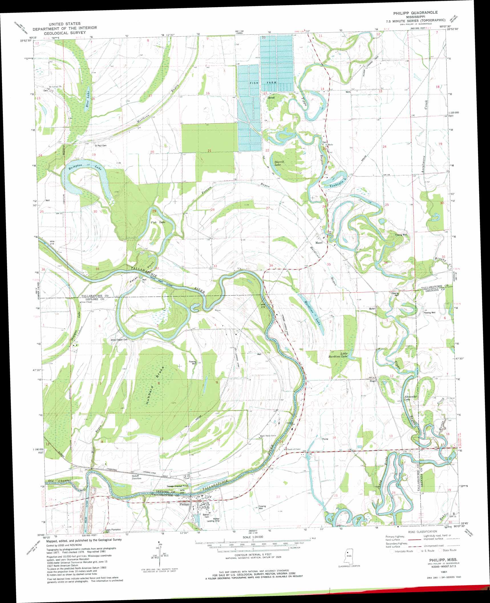
USGS Topo Quad 33090g2 - 1:24,000 scale
| Topo Map Name: | Philipp |
| USGS Topo Quad ID: | 33090g2 |
| Print Size: | ca. 21 1/4" wide x 27" high |
| Southeast Coordinates: | 33.75° N latitude / 90.125° W longitude |
| Map Center Coordinates: | 33.8125° N latitude / 90.1875° W longitude |
| U.S. State: | MS |
| Filename: | o33090g2.jpg |
| Download Map JPG Image: | Philipp topo map 1:24,000 scale |
| Map Type: | Topographic |
| Topo Series: | 7.5´ |
| Map Scale: | 1:24,000 |
| Source of Map Images: | United States Geological Survey (USGS) |
| Alternate Map Versions: |
Philipp SW MS 1974, updated 1975 Download PDF Buy paper map Philipp MS 1981, updated 1982 Download PDF Buy paper map Philipp MS 2012 Download PDF Buy paper map Philipp MS 2015 Download PDF Buy paper map |
1:24,000 Topo Quads surrounding Philipp
Tutwiler |
Vance |
Fishhook Lake |
Charleston |
Oakland |
Rome |
Webb |
Tippo |
Paynes |
Tillatoba |
Brooks |
Glendora |
Philipp |
Cascilla |
Holcomb |
Rattlesnake Bayou |
Schlater |
Money |
Avalon |
Jefferson |
Bear Gut Bayou |
Shellmound |
Greenwood |
Browning |
North Carrollton |
> Back to 33090e1 at 1:100,000 scale
> Back to 33090a1 at 1:250,000 scale
> Back to U.S. Topo Maps home
Philipp topo map: Gazetteer
Philipp: Bends
Pecan Point Cut-Off elevation 42m 137′Philipp: Capes
Pecan Point elevation 38m 124′Philipp: Dams
Blue Channel Catfish Incorporated Lake Dam elevation 43m 141′Blue Channel Catfish Incorporated Lake Dam elevation 42m 137′
Philipp: Guts
Hardtime Bayou elevation 41m 134′Possum Bayou elevation 41m 134′
Philipp: Lakes
Alexander Lake elevation 39m 127′Blue Lake elevation 40m 131′
Fish Lake elevation 38m 124′
Hampton Lake elevation 39m 127′
Hardtime Lake elevation 40m 131′
Little Hardtime Lake elevation 41m 134′
Shegogue Lake elevation 43m 141′
Sherrill Lake elevation 43m 141′
Yonkapin Lake elevation 42m 137′
Philipp: Populated Places
Distall elevation 44m 144′Hatten elevation 42m 137′
Hugo elevation 41m 134′
Macel elevation 43m 141′
Mehr elevation 41m 134′
Philipp elevation 48m 157′
Sisloff Junction elevation 44m 144′
Philipp: Streams
Ascalmore Creek elevation 40m 131′Brushy Creek elevation 40m 131′
Martin Creek elevation 38m 124′
Matthews Bayou elevation 40m 131′
Mill Bayou elevation 38m 124′
Philipp: Swamps
Long Brake elevation 38m 124′Philipp digital topo map on disk
Buy this Philipp topo map showing relief, roads, GPS coordinates and other geographical features, as a high-resolution digital map file on DVD: