Sunnymead Topo Map California
To zoom in, hover over the map of Sunnymead
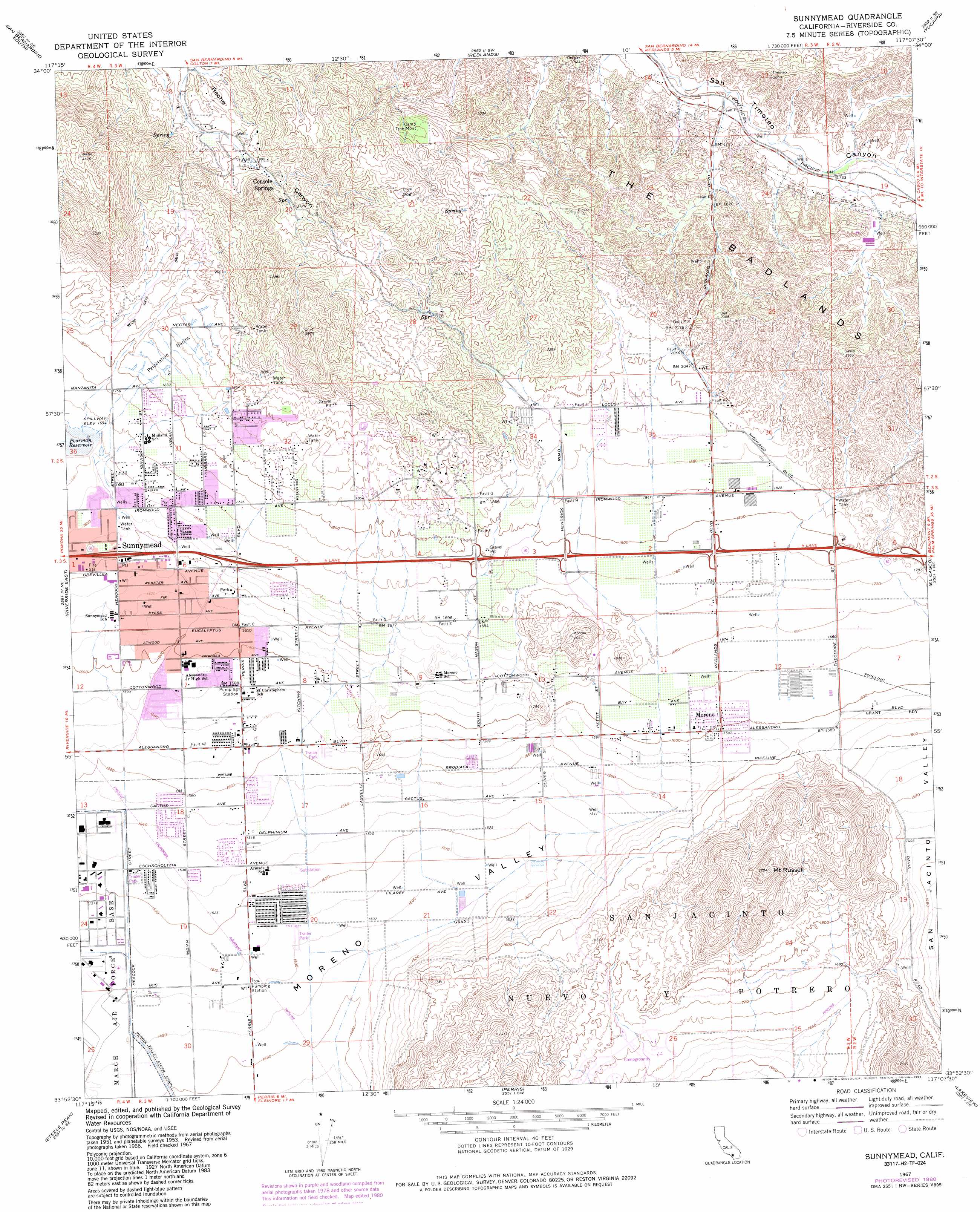
USGS Topo Quad 33117h2 - 1:24,000 scale
| Topo Map Name: | Sunnymead |
| USGS Topo Quad ID: | 33117h2 |
| Print Size: | ca. 21 1/4" wide x 27" high |
| Southeast Coordinates: | 33.875° N latitude / 117.125° W longitude |
| Map Center Coordinates: | 33.9375° N latitude / 117.1875° W longitude |
| U.S. State: | CA |
| Filename: | o33117h2.jpg |
| Download Map JPG Image: | Sunnymead topo map 1:24,000 scale |
| Map Type: | Topographic |
| Topo Series: | 7.5´ |
| Map Scale: | 1:24,000 |
| Source of Map Images: | United States Geological Survey (USGS) |
| Alternate Map Versions: |
Sunnymead CA 1953, updated 1954 Download PDF Buy paper map Sunnymead CA 1953, updated 1958 Download PDF Buy paper map Sunnymead CA 1967, updated 1968 Download PDF Buy paper map Sunnymead CA 1967, updated 1976 Download PDF Buy paper map Sunnymead CA 1967, updated 1980 Download PDF Buy paper map Sunnymead CA 1967, updated 1985 Download PDF Buy paper map Sunnymead CA 1967, updated 1985 Download PDF Buy paper map Sunnymead CA 2012 Download PDF Buy paper map Sunnymead CA 2015 Download PDF Buy paper map |
1:24,000 Topo Quads surrounding Sunnymead
Devore |
San Bernardino North |
Harrison Mountain |
Keller Peak |
Big Bear Lake |
Fontana |
San Bernardino South |
Redlands |
Yucaipa |
Forest Falls |
Riverside West |
Riverside East |
Sunnymead |
El Casco |
Beaumont |
Lake Mathews |
Steele Peak |
Perris |
Lakeview |
San Jacinto |
Alberhill |
Lake Elsinore |
Romoland |
Winchester |
Hemet |
> Back to 33117e1 at 1:100,000 scale
> Back to 33116a1 at 1:250,000 scale
> Back to U.S. Topo Maps home
Sunnymead topo map: Gazetteer
Sunnymead: Dams
Pigeon Pass 1003-006 Dam elevation 512m 1679′Sunnymead: Parks
Gateway Park elevation 537m 1761′John F Kennedy Veterans Memorial Park elevation 468m 1535′
Morrison Park elevation 492m 1614′
Pedrorena Park elevation 455m 1492′
Smith and Schaffer Memorial Baseball Field elevation 458m 1502′
Sunnymead Park elevation 499m 1637′
Upland Game Hunting Area elevation 500m 1640′
Victoriano Park elevation 454m 1489′
Woodland Park elevation 470m 1541′
Sunnymead: Populated Places
Moonlight Rim elevation 633m 2076′Moreno elevation 488m 1601′
Moreno Valley elevation 497m 1630′
Serrano Heights elevation 641m 2103′
Sunnymead elevation 500m 1640′
Sunnymead: Post Offices
Moreno Post Office elevation 488m 1601′Postal Avenue Station Post Office elevation 500m 1640′
Sunnymead Post Office elevation 501m 1643′
Sunnymead: Ranges
Kalmia Hills elevation 733m 2404′Sunnymead: Reservoirs
Poorman Reservoir elevation 512m 1679′Sunnymead: Springs
Console Springs elevation 615m 2017′Sunnymead: Summits
Mount Russell elevation 822m 2696′Olive Hill elevation 901m 2956′
Pettit Hill elevation 619m 2030′
Sunnymead: Valleys
Moreno Valley elevation 449m 1473′Sunnymead digital topo map on disk
Buy this Sunnymead topo map showing relief, roads, GPS coordinates and other geographical features, as a high-resolution digital map file on DVD: