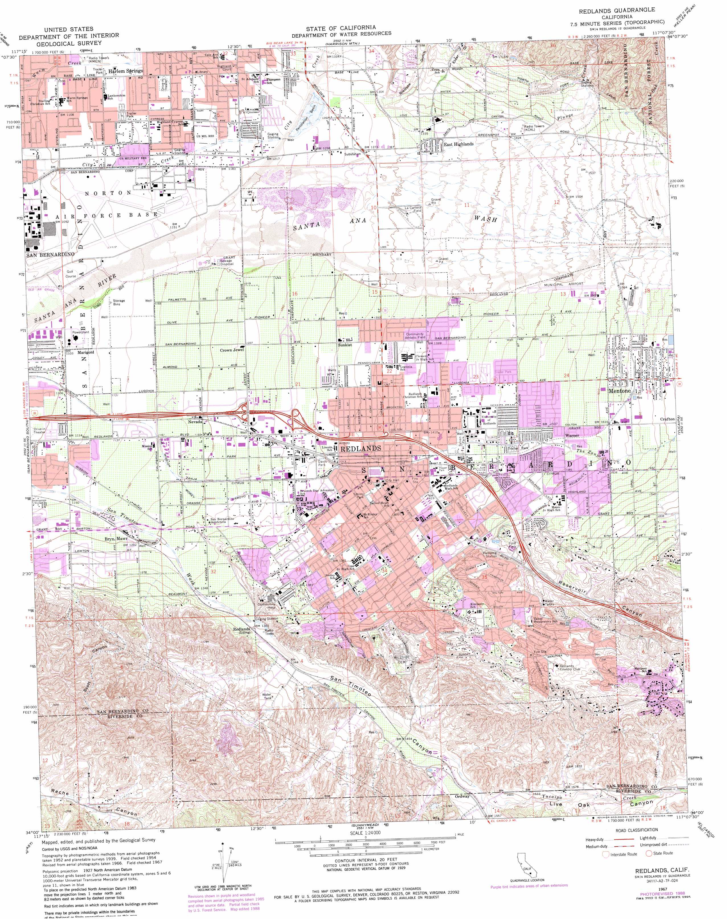
Redlands Topo Map California
To zoom in, hover over the map of Redlands
USGS Topo Quad 34117a2 - 1:24,000 scale
| Topo Map Name: | Redlands |
| USGS Topo Quad ID: | 34117a2 |
| Print Size: | ca. 21 1/4" wide x 27" high |
| Southeast Coordinates: | 34° N latitude / 117.125° W longitude |
| Map Center Coordinates: | 34.0625° N latitude / 117.1875° W longitude |
| U.S. State: | CA |
| Filename: | o34117a2.jpg |
| Download Map JPG Image: | Redlands topo map 1:24,000 scale |
| Map Type: | Topographic |
| Topo Series: | 7.5´ |
| Map Scale: | 1:24,000 |
| Source of Map Images: | United States Geological Survey (USGS) |
| Alternate Map Versions: |
Redlands CA 1954, updated 1955 Download PDF Buy paper map Redlands CA 1954, updated 1963 Download PDF Buy paper map Redlands CA 1967, updated 1969 Download PDF Buy paper map Redlands CA 1967, updated 1979 Download PDF Buy paper map Redlands CA 1967, updated 1980 Download PDF Buy paper map Redlands CA 1967, updated 1986 Download PDF Buy paper map Redlands CA 1967, updated 1988 Download PDF Buy paper map Redlands CA 1967, updated 1988 Download PDF Buy paper map Redlands CA 1975, updated 1977 Download PDF Buy paper map Redlands CA 1996, updated 1999 Download PDF Buy paper map Redlands CA 2012 Download PDF Buy paper map Redlands CA 2015 Download PDF Buy paper map |
| FStopo: | US Forest Service topo Redlands is available: Download FStopo PDF Download FStopo TIF |
1:24,000 Topo Quads surrounding Redlands
Cajon |
Silverwood Lake |
Lake Arrowhead |
Butler Peak |
Fawnskin |
Devore |
San Bernardino North |
Harrison Mountain |
Keller Peak |
Big Bear Lake |
Fontana |
San Bernardino South |
Redlands |
Yucaipa |
Forest Falls |
Riverside West |
Riverside East |
Sunnymead |
El Casco |
Beaumont |
Lake Mathews |
Steele Peak |
Perris |
Lakeview |
San Jacinto |
> Back to 34117a1 at 1:100,000 scale
> Back to 34116a1 at 1:250,000 scale
> Back to U.S. Topo Maps home
Redlands topo map: Gazetteer
Redlands: Airports
Redlands Airport elevation 465m 1525′San Bernardino International Airport elevation 340m 1115′
Redlands: Canals
Morey Arroyo elevation 370m 1213′North Fork Canal elevation 490m 1607′
The Mission Zanja elevation 360m 1181′
Redlands: Crossings
Interchange 75 elevation 342m 1122′Interchange 76 elevation 360m 1181′
Interchange 77A elevation 378m 1240′
Interchange 77B elevation 384m 1259′
Interchange 77C elevation 391m 1282′
Interchange 79 elevation 415m 1361′
Interchange 80 elevation 445m 1459′
Interchange 81 elevation 494m 1620′
Redlands: Levees
Plunge Creek Levee elevation 448m 1469′Redlands: Parks
Abraham Lincoln Shrine elevation 415m 1361′Brookside Park elevation 397m 1302′
Caroline Park elevation 591m 1938′
Crafton Park elevation 492m 1614′
Davis Park elevation 396m 1299′
Ford Park elevation 486m 1594′
Lugonia Park elevation 415m 1361′
Pepper Park elevation 430m 1410′
Prospect Park elevation 480m 1574′
Smiley Park elevation 414m 1358′
Sylvan Park elevation 442m 1450′
Ted Runner Stadium elevation 443m 1453′
Redlands: Populated Places
Browns (historical) elevation 471m 1545′Bryn Mawr elevation 361m 1184′
Crown Jewel elevation 373m 1223′
East Highlands elevation 409m 1341′
Harlem Springs elevation 350m 1148′
Lugonia Homes elevation 419m 1374′
Marigold elevation 339m 1112′
Mentone elevation 503m 1650′
Nevada elevation 365m 1197′
Ordway elevation 471m 1545′
Plymouth Village elevation 466m 1528′
Redlands elevation 414m 1358′
Redlands Heights elevation 530m 1738′
Smiley Heights elevation 474m 1555′
Sunkist elevation 402m 1318′
University Village elevation 448m 1469′
Warm Springs elevation 335m 1099′
Warner elevation 477m 1564′
Redlands: Post Offices
Bryn Mawr Post Office elevation 363m 1190′Highland Post Office elevation 370m 1213′
Lugonia Post Office elevation 393m 1289′
Mentone Post Office elevation 508m 1666′
Redlands Post Office elevation 410m 1345′
Redlands: Streams
Oak Creek elevation 468m 1535′Plunge Creek elevation 358m 1174′
Sand Creek elevation 348m 1141′
Santa Ana Wash elevation 343m 1125′
The Zanja elevation 421m 1381′
Yucaipa Creek elevation 469m 1538′
Redlands: Valleys
Bledsoe Gulch elevation 409m 1341′Elder Gulch elevation 429m 1407′
Live Oak Canyon elevation 471m 1545′
Reservoir Canyon elevation 477m 1564′
San Timoteo Canyon elevation 402m 1318′
Scott Canyon elevation 407m 1335′
Redlands: Woods
Centennial Orange Grove elevation 451m 1479′Redlands digital topo map on disk
Buy this Redlands topo map showing relief, roads, GPS coordinates and other geographical features, as a high-resolution digital map file on DVD: