Spencer Canyon Topo Map Arizona
To zoom in, hover over the map of Spencer Canyon
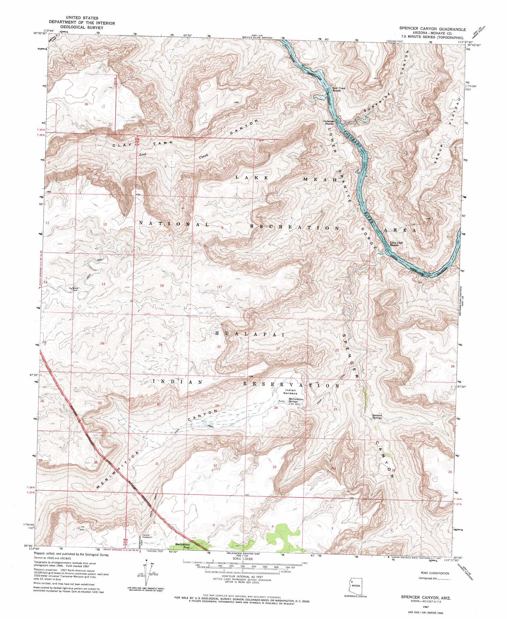
USGS Topo Quad 35113g6 - 1:24,000 scale
| Topo Map Name: | Spencer Canyon |
| USGS Topo Quad ID: | 35113g6 |
| Print Size: | ca. 21 1/4" wide x 27" high |
| Southeast Coordinates: | 35.75° N latitude / 113.625° W longitude |
| Map Center Coordinates: | 35.8125° N latitude / 113.6875° W longitude |
| U.S. State: | AZ |
| Filename: | o35113g6.jpg |
| Download Map JPG Image: | Spencer Canyon topo map 1:24,000 scale |
| Map Type: | Topographic |
| Topo Series: | 7.5´ |
| Map Scale: | 1:24,000 |
| Source of Map Images: | United States Geological Survey (USGS) |
| Alternate Map Versions: |
Spencer Canyon AZ 1967, updated 1970 Download PDF Buy paper map Spencer Canyon AZ 2011 Download PDF Buy paper map Spencer Canyon AZ 2014 Download PDF Buy paper map |
1:24,000 Topo Quads surrounding Spencer Canyon
Columbine Falls |
Bat Cave |
Tincanebitts Point |
Mount Dellenbaugh |
Whitmore Point Sw |
Grapevine Canyon |
Quartermaster Canyon |
Devils Slide Rapids |
Amos Point |
Price Point |
Quartermaster Canyon Sw |
Horse Flat |
Spencer Canyon |
Separation Canyon |
Travertine Rapids |
Music Mountains Nw |
Music Mountains Ne |
Milkweed Canyon Nw |
Hindu Canyon |
Peach Springs Canyon |
Music Mountains Sw |
Music Mountains Se |
Milkweed Canyon Sw |
Milkweed Canyon Se |
Peach Springs |
> Back to 35113e1 at 1:100,000 scale
> Back to 35112a1 at 1:250,000 scale
> Back to U.S. Topo Maps home
Spencer Canyon topo map: Gazetteer
Spencer Canyon: Cliffs
Lava Cliff elevation 906m 2972′Spencer Canyon: Flats
Indian Gardens elevation 800m 2624′Spencer Canyon: Rapids
Lava Cliff Rapids elevation 367m 1204′Lost Creek Rapids elevation 367m 1204′
Surprise Rapids elevation 375m 1230′
Spencer Canyon: Reservoirs
Meriwhitica Tank elevation 1415m 4642′Spencer Canyon: Springs
Meriwhitica Springs elevation 811m 2660′Spencer Springs elevation 557m 1827′
White Spring elevation 1394m 4573′
Spencer Canyon: Streams
Lost Creek elevation 367m 1204′Spencer Canyon: Valleys
Clay Tank Canyon elevation 367m 1204′Meriwhitica Canyon elevation 521m 1709′
Spencer Canyon elevation 367m 1204′
Surprise Canyon elevation 395m 1295′
Spencer Canyon digital topo map on disk
Buy this Spencer Canyon topo map showing relief, roads, GPS coordinates and other geographical features, as a high-resolution digital map file on DVD: