Oatman Topo Map Arizona
To zoom in, hover over the map of Oatman
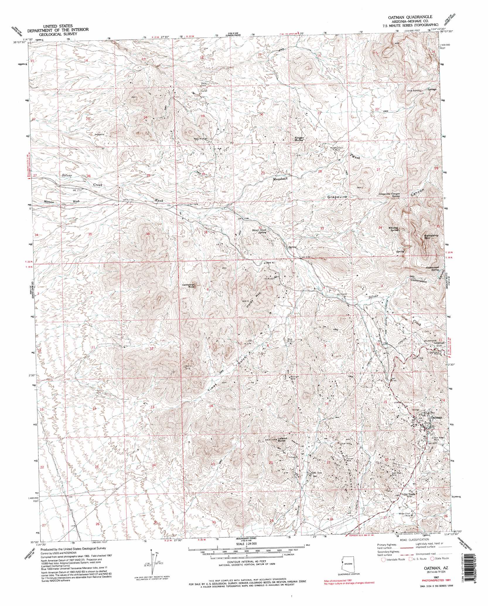
USGS Topo Quad 35114a4 - 1:24,000 scale
| Topo Map Name: | Oatman |
| USGS Topo Quad ID: | 35114a4 |
| Print Size: | ca. 21 1/4" wide x 27" high |
| Southeast Coordinates: | 35° N latitude / 114.375° W longitude |
| Map Center Coordinates: | 35.0625° N latitude / 114.4375° W longitude |
| U.S. State: | AZ |
| Filename: | o35114a4.jpg |
| Download Map JPG Image: | Oatman topo map 1:24,000 scale |
| Map Type: | Topographic |
| Topo Series: | 7.5´ |
| Map Scale: | 1:24,000 |
| Source of Map Images: | United States Geological Survey (USGS) |
| Alternate Map Versions: |
Oatman AZ 1967, updated 1969 Download PDF Buy paper map Oatman AZ 1967, updated 1977 Download PDF Buy paper map Oatman AZ 1967, updated 1990 Download PDF Buy paper map Oatman AZ 1967, updated 1995 Download PDF Buy paper map Oatman AZ 2011 Download PDF Buy paper map Oatman AZ 2014 Download PDF Buy paper map |
1:24,000 Topo Quads surrounding Oatman
Spirit Mountain |
Spirit Mountain Se |
Burns Spring |
Grasshopper Junction Se |
Cerbat |
Bridge Canyon |
Davis Dam |
Union Pass |
Secret Pass |
Kingman Nw |
Mount Manchester |
Davis Dam Se |
Oatman |
Mount Nutt |
Kingman Sw |
Needles Nw |
Needles Ne |
Boundary Cone |
Warm Springs |
Yucca Nw |
Needles Sw |
Needles |
Warm Springs Sw |
Warm Springs Se |
Yucca |
> Back to 35114a1 at 1:100,000 scale
> Back to 35114a1 at 1:250,000 scale
> Back to U.S. Topo Maps home
Oatman topo map: Gazetteer
Oatman: Mines
Gold Dust Mine elevation 789m 2588′Goldroad Mine elevation 905m 2969′
Midnight Mine elevation 791m 2595′
Moss Mine elevation 660m 2165′
Mossback Mine elevation 746m 2447′
Pioneer Mine elevation 732m 2401′
Tom Reed Mine elevation 818m 2683′
United Eastern Mine elevation 865m 2837′
United Western Mine elevation 859m 2818′
White Chief Mine elevation 732m 2401′
Oatman: Pillars
Cathedral Rock elevation 842m 2762′Oatman: Populated Places
Oatman elevation 826m 2709′Oatman: Post Offices
Oatman Post Office elevation 825m 2706′Oatman: Springs
Cottonwood Spring elevation 835m 2739′Grapevine Canyon Spring elevation 808m 2650′
Silver Creek Spring elevation 0m 0′
Whiskey Spring elevation 855m 2805′
Oatman: Streams
Mossback Wash elevation 595m 1952′Oatman: Summits
Battleship Mountain elevation 1258m 4127′Finger Butte elevation 783m 2568′
Hardy Mountain elevation 958m 3143′
Leland Butte elevation 893m 2929′
Negrohead elevation 912m 2992′
Oatman: Valleys
Cottonwood Canyon elevation 764m 2506′Grapevine Canyon elevation 608m 1994′
Times Gulch elevation 537m 1761′
Oatman digital topo map on disk
Buy this Oatman topo map showing relief, roads, GPS coordinates and other geographical features, as a high-resolution digital map file on DVD:
Southern Sierra Nevada, California & Southern Nevada
Buy digital topo maps: Southern Sierra Nevada, California & Southern Nevada