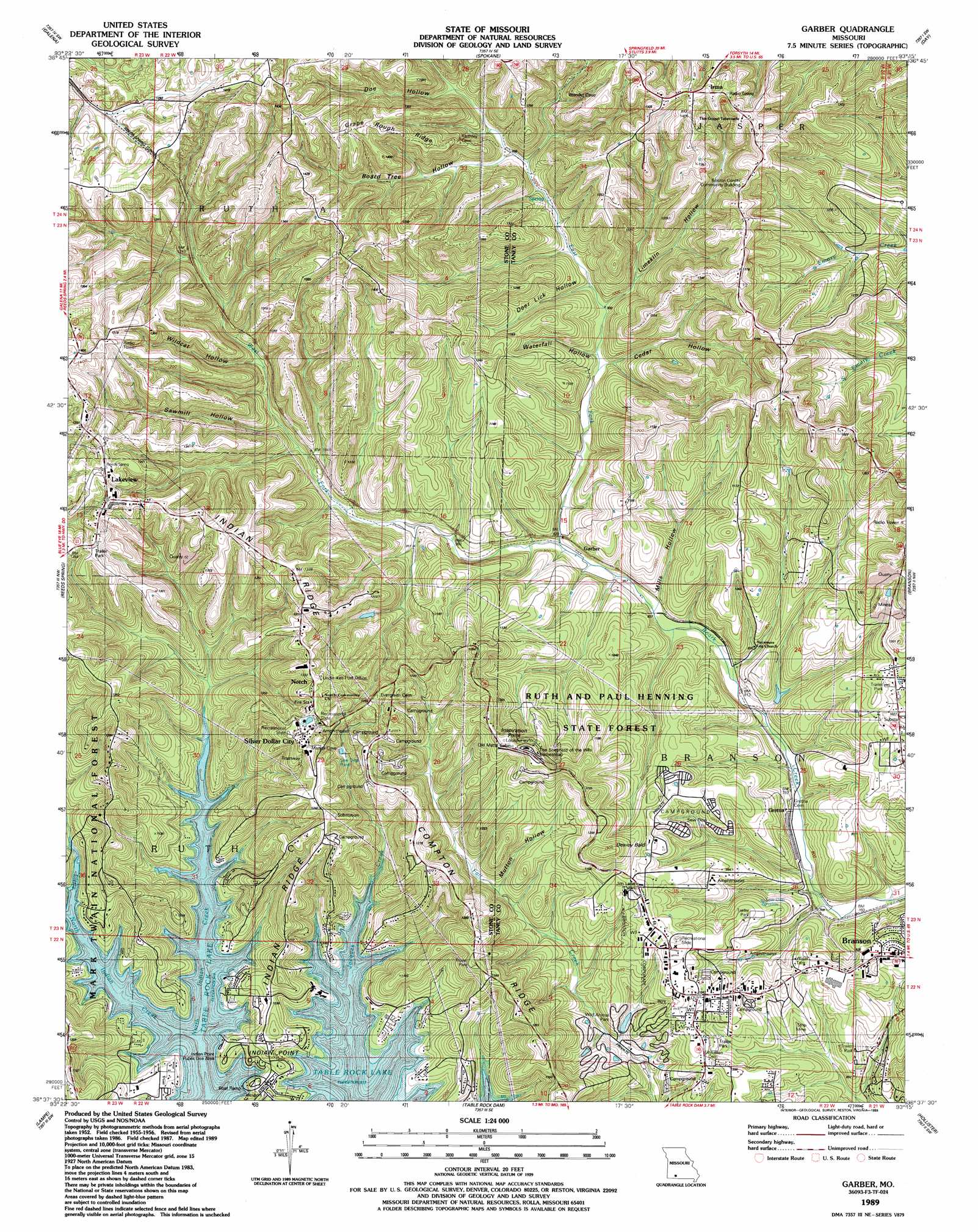
Garber Topo Map Missouri
To zoom in, hover over the map of Garber
USGS Topo Quad 36093f3 - 1:24,000 scale
| Topo Map Name: | Garber |
| USGS Topo Quad ID: | 36093f3 |
| Print Size: | ca. 21 1/4" wide x 27" high |
| Southeast Coordinates: | 36.625° N latitude / 93.25° W longitude |
| Map Center Coordinates: | 36.6875° N latitude / 93.3125° W longitude |
| U.S. State: | MO |
| Filename: | o36093f3.jpg |
| Download Map JPG Image: | Garber topo map 1:24,000 scale |
| Map Type: | Topographic |
| Topo Series: | 7.5´ |
| Map Scale: | 1:24,000 |
| Source of Map Images: | United States Geological Survey (USGS) |
| Alternate Map Versions: |
Garber MO 1950, updated 1981 Download PDF Buy paper map Garber MO 1956, updated 1957 Download PDF Buy paper map Garber MO 1956, updated 1974 Download PDF Buy paper map Garber MO 1956, updated 1976 Download PDF Buy paper map Garber MO 1989, updated 1989 Download PDF Buy paper map Garber MO 2012 Download PDF Buy paper map Garber MO 2015 Download PDF Buy paper map |
| FStopo: | US Forest Service topo Garber is available: Download FStopo PDF Download FStopo TIF |
1:24,000 Topo Quads surrounding Garber
Crane |
Hurley |
Highlandville |
Selmore |
Chadwick |
Elsey |
Galena |
Spokane |
Day |
Garrison |
Cape Fair |
Reeds Spring |
Garber |
Branson |
Forsyth |
Viola |
Lampe |
Table Rock Dam |
Hollister |
Mincy |
Grandview |
Blue Eye |
Denver |
Omaha |
Omaha Ne |
> Back to 36093e1 at 1:100,000 scale
> Back to 36092a1 at 1:250,000 scale
> Back to U.S. Topo Maps home
Garber topo map: Gazetteer
Garber: Airports
Branson Memorial Airport elevation 314m 1030′John the Diver Airport elevation 354m 1161′
Table Rock Heliport elevation 314m 1030′
Garber: Capes
Indian Point elevation 325m 1066′Inspiration Point elevation 417m 1368′
Garber: Dams
Shepherd of the Hills Historical Society Dam elevation 261m 856′Garber: Forests
Ruth and Paul Henning Conservation Area elevation 333m 1092′Garber: Parks
Indian Point Park elevation 301m 987′Indian Point Public Use Area elevation 280m 918′
Jack Justus Park elevation 316m 1036′
Keeter Park elevation 318m 1043′
Silver Dollar City elevation 393m 1289′
White River Balds Natural Area elevation 319m 1046′
Garber: Populated Places
Branson West elevation 417m 1368′Garber elevation 277m 908′
Gretna elevation 247m 810′
Indian Point elevation 297m 974′
Irma elevation 423m 1387′
Lakeview elevation 416m 1364′
Marvel Cave elevation 293m 961′
Notch elevation 403m 1322′
Silver Dollar City elevation 406m 1332′
Thelma elevation 380m 1246′
Garber: Post Offices
Uncle Ikes Post Office (historical) elevation 400m 1312′Garber: Reservoirs
McDonald Lake elevation 261m 856′Garber: Ridges
Compton Ridge elevation 384m 1259′Grape Rough Ridge elevation 429m 1407′
Indian Ridge elevation 367m 1204′
Indian Ridge elevation 405m 1328′
Garber: Streams
Dewey Cove elevation 251m 823′East Fork Roark Creek elevation 262m 859′
Little North Indian Creek elevation 279m 915′
West Fork Roark Creek elevation 262m 859′
Garber: Summits
Coxs Bald elevation 344m 1128′Dewey Bald elevation 408m 1338′
Garber Bald elevation 355m 1164′
Long Bald elevation 349m 1145′
South Coxs Bald elevation 367m 1204′
White Cedar Bald elevation 391m 1282′
Garber: Tunnels
Reeds Spring Tunnel elevation 394m 1292′Garber: Valleys
Board Tree Hollow elevation 305m 1000′Cedar Hollow elevation 280m 918′
Deer Lick Hollow elevation 288m 944′
Doe Hollow elevation 321m 1053′
Limekiln Hollow elevation 285m 935′
Mills Hollow elevation 262m 859′
Mutton Hollow elevation 279m 915′
Possum Haw Hollow elevation 260m 853′
Sawmill Hollow elevation 292m 958′
Waterfall Hollow elevation 279m 915′
Wildcat Hollow elevation 303m 994′
Garber digital topo map on disk
Buy this Garber topo map showing relief, roads, GPS coordinates and other geographical features, as a high-resolution digital map file on DVD: