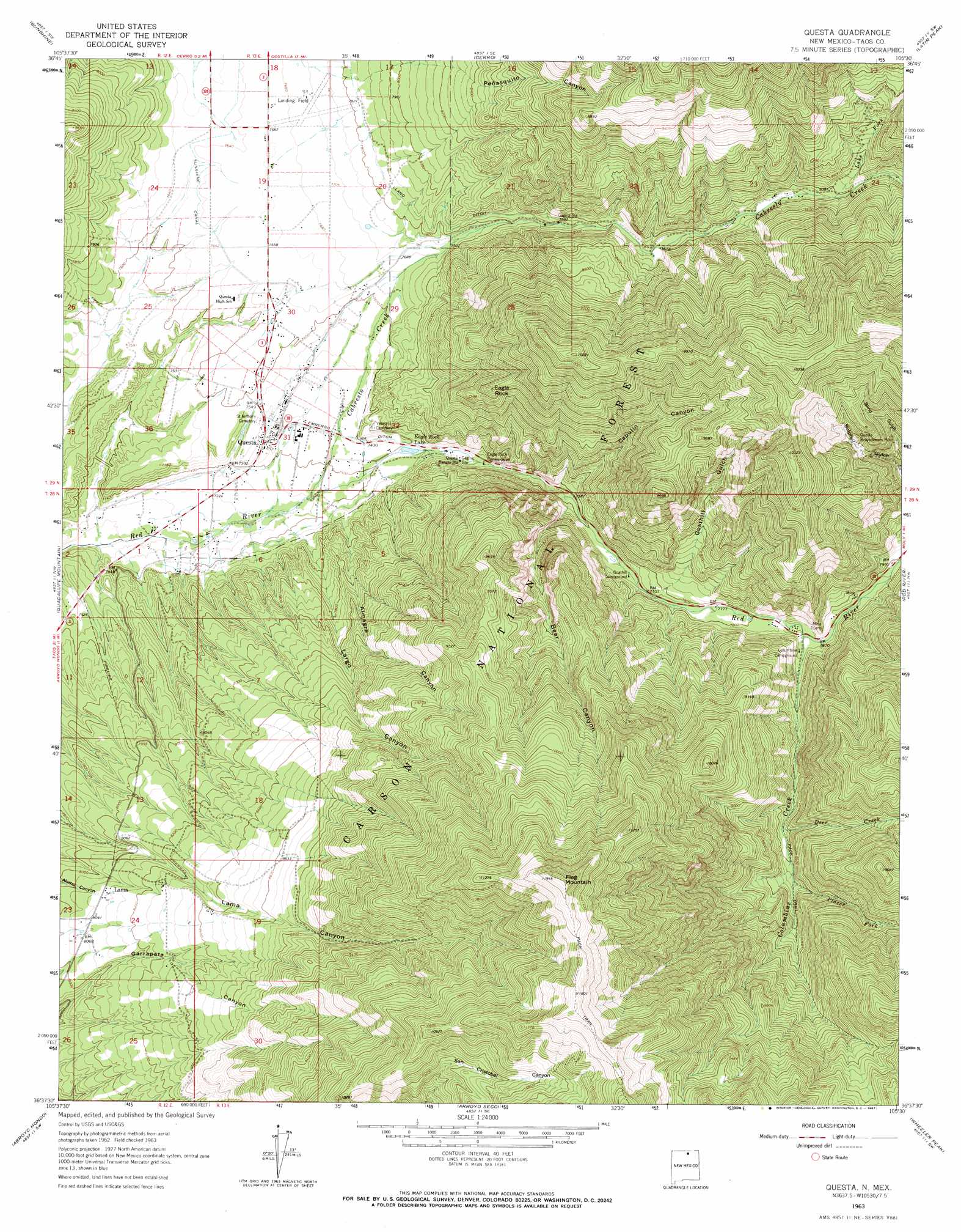
Questa Topo Map New Mexico
To zoom in, hover over the map of Questa
USGS Topo Quad 36105f5 - 1:24,000 scale
| Topo Map Name: | Questa |
| USGS Topo Quad ID: | 36105f5 |
| Print Size: | ca. 21 1/4" wide x 27" high |
| Southeast Coordinates: | 36.625° N latitude / 105.5° W longitude |
| Map Center Coordinates: | 36.6875° N latitude / 105.5625° W longitude |
| U.S. State: | NM |
| Filename: | o36105f5.jpg |
| Download Map JPG Image: | Questa topo map 1:24,000 scale |
| Map Type: | Topographic |
| Topo Series: | 7.5´ |
| Map Scale: | 1:24,000 |
| Source of Map Images: | United States Geological Survey (USGS) |
| Alternate Map Versions: |
Questa NM 1963, updated 1967 Download PDF Buy paper map Questa NM 1995, updated 1997 Download PDF Buy paper map Questa NM 2011 Download PDF Buy paper map Questa NM 2013 Download PDF Buy paper map |
| FStopo: | US Forest Service topo Questa is available: Download FStopo PDF Download FStopo TIF |
1:24,000 Topo Quads surrounding Questa
La Segita Peaks Ne |
Ute Mountain |
Costilla |
Amalia |
Big Costilla Peak |
Cerro De La Olla |
Sunshine |
Cerro |
Latir Peak |
Comanche Point |
Tres Piedras Ne |
Guadalupe Mountain |
Questa |
Red River |
Red River Pass |
Cerro De Los Taoses |
Arroyo Hondo |
Arroyo Seco |
Wheeler Peak |
Eagle Nest |
Tres Orejas |
Los Cordovas |
Taos |
Pueblo Peak |
Palo Flechado Pass |
> Back to 36105e1 at 1:100,000 scale
> Back to 36104a1 at 1:250,000 scale
> Back to U.S. Topo Maps home
Questa topo map: Gazetteer
Questa: Airports
Questa Municipal Airport elevation 2330m 7644′Questa: Canals
Embergo Ditch elevation 2275m 7463′Llano Ditch elevation 2397m 7864′
Questa: Lakes
Eagle Rock Lake elevation 2269m 7444′Questa: Mines
Bear Canyon Prospects elevation 2333m 7654′Bernhardt Prospects elevation 2587m 8487′
BJB Prospects elevation 2507m 8225′
Black Point elevation 2309m 7575′
Columbine Creek Prospect elevation 2412m 7913′
Garrapata elevation 2711m 8894′
Gray Hawk Prospect elevation 2709m 8887′
Hanosh elevation 2329m 7641′
Hercules Group elevation 2790m 9153′
Horner Prospect elevation 2763m 9064′
Log Cabin Canyon elevation 2658m 8720′
Lower Cabresto Canyon elevation 2472m 8110′
Nickel Plate elevation 2481m 8139′
Questa Molybdenum Mine elevation 2676m 8779′
Red River elevation 2269m 7444′
Silver Mine elevation 2439m 8001′
Williams Claims elevation 2450m 8038′
Questa: Pillars
Eagle Rock elevation 2718m 8917′Questa: Populated Places
Lama elevation 2475m 8120′Questa elevation 2274m 7460′
Questa: Post Offices
Questa Post Office elevation 2274m 7460′Questa: Springs
Embargo Spring elevation 2202m 7224′Questa: Streams
Cabresto Creek elevation 2244m 7362′Columbine Creek elevation 2394m 7854′
Deer Creek elevation 2548m 8359′
Lake Fork elevation 2564m 8412′
Placer Fork elevation 2590m 8497′
Questa: Summits
Flag Mountain elevation 3639m 11938′Questa: Valleys
Almagre Canyon elevation 2291m 7516′Bear Canyon elevation 2321m 7614′
Blind Gulch elevation 2545m 8349′
Capulin Canyon elevation 2369m 7772′
Goathill Gulch elevation 2385m 7824′
Largo Canyon elevation 2269m 7444′
Peñasquito Canyon elevation 2583m 8474′
Questa: Wells
10023 Water Well elevation 2516m 8254′10024 Water Well elevation 2335m 7660′
Questa digital topo map on disk
Buy this Questa topo map showing relief, roads, GPS coordinates and other geographical features, as a high-resolution digital map file on DVD: