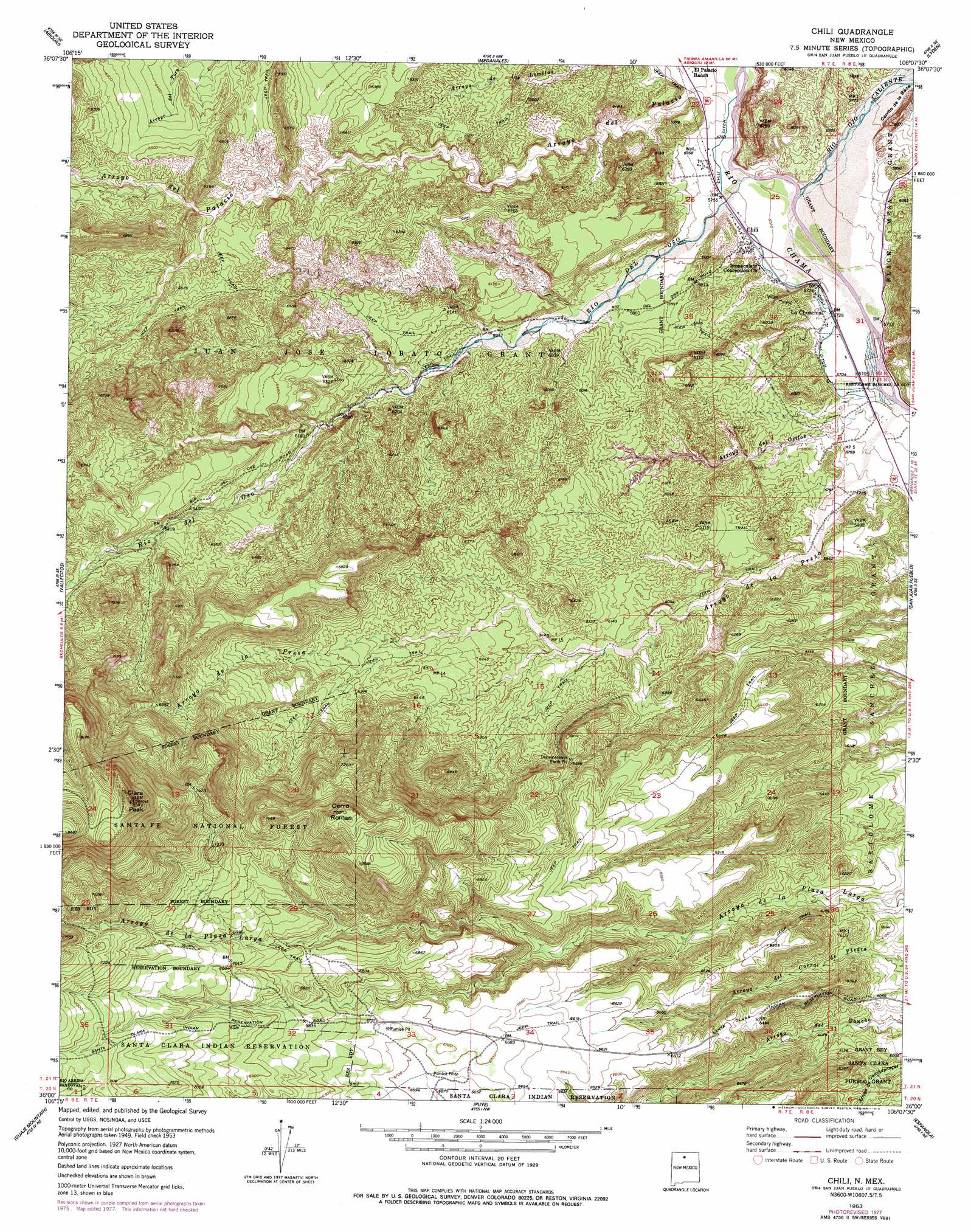
Chili Topo Map New Mexico
To zoom in, hover over the map of Chili
USGS Topo Quad 36106a2 - 1:24,000 scale
| Topo Map Name: | Chili |
| USGS Topo Quad ID: | 36106a2 |
| Print Size: | ca. 21 1/4" wide x 27" high |
| Southeast Coordinates: | 36° N latitude / 106.125° W longitude |
| Map Center Coordinates: | 36.0625° N latitude / 106.1875° W longitude |
| U.S. State: | NM |
| Filename: | o36106a2.jpg |
| Download Map JPG Image: | Chili topo map 1:24,000 scale |
| Map Type: | Topographic |
| Topo Series: | 7.5´ |
| Map Scale: | 1:24,000 |
| Source of Map Images: | United States Geological Survey (USGS) |
| Alternate Map Versions: |
Chili NM 1953, updated 1954 Download PDF Buy paper map Chili NM 1953, updated 1963 Download PDF Buy paper map Chili NM 1953, updated 1979 Download PDF Buy paper map Chili NM 2002, updated 2003 Download PDF Buy paper map Chili NM 2011 Download PDF Buy paper map Chili NM 2013 Download PDF Buy paper map Chili NM 2017 Download PDF Buy paper map |
| FStopo: | US Forest Service topo Chili is available: Download FStopo PDF Download FStopo TIF |
1:24,000 Topo Quads surrounding Chili
Ghost Ranch |
Canjilon Se |
El Rito |
Ojo Caliente |
Taos Junction |
Canones |
Abiquiu |
Medanales |
Lyden |
Velarde |
Polvadera Peak |
Vallecitos |
Chili |
San Juan Pueblo |
Chimayo |
Valle Toledo |
Guaje Mountain |
Puye |
Espanola |
Cundiyo |
Bland |
Frijoles |
White Rock |
Horcado Ranch |
Tesuque |
> Back to 36106a1 at 1:100,000 scale
> Back to 36106a1 at 1:250,000 scale
> Back to U.S. Topo Maps home
Chili topo map: Gazetteer
Chili: Canals
Chili Ditch elevation 1752m 5748′Chili: Mines
Cupar Mine elevation 2081m 6827′Pit 67-23-5 elevation 2081m 6827′
Rhodes Diatomite Pit elevation 1948m 6391′
Santa Clara Pumice Pit 1 elevation 1827m 5994′
Santa Clara Pumice Pit 2 elevation 1862m 6108′
Sebastian and Martin Pit elevation 2081m 6827′
Chili: Populated Places
Chili elevation 1751m 5744′Clara Peak elevation 2601m 8533′
La Chuachia elevation 1749m 5738′
Chili: Reservoirs
Clara Peak Trick Tank elevation 2033m 6669′Chili: Springs
Henry Spring elevation 1763m 5784′Chili: Streams
Arroyo de la Presa elevation 1736m 5695′Arroyo del Ojitos elevation 1738m 5702′
Arroyo del Palacio elevation 1749m 5738′
La Canada del Almagre elevation 1867m 6125′
Rio del Oso elevation 1745m 5725′
Rio Ojo Caliente elevation 1742m 5715′
Chili: Summits
Cerrito de la Baca elevation 1753m 5751′Cerrito de la Baca elevation 1857m 6092′
Cerro Roman elevation 2345m 7693′
Chili: Trails
Lemitas Trail elevation 1818m 5964′Palacio Trail elevation 1952m 6404′
Chili: Wells
RG-14729 Water Well elevation 1749m 5738′RG-15798 Water Well elevation 1752m 5748′
RG-1607 Water Well elevation 1765m 5790′
RG-17211 Water Well elevation 1936m 6351′
RG-21083 Water Well elevation 1755m 5757′
RG-22888 Water Well elevation 1904m 6246′
RG-26149 Water Well elevation 1778m 5833′
RG-26659 Water Well elevation 1966m 6450′
RG-27415 Water Well elevation 1981m 6499′
RG-27605 Water Well elevation 1764m 5787′
RG-27693 Water Well elevation 1754m 5754′
RG-28297 Water Well elevation 1909m 6263′
RG-29007 Water Well elevation 1779m 5836′
RG-30520 Water Well elevation 1762m 5780′
RG-30781 Water Well elevation 1760m 5774′
RG-5858 Water Well elevation 1755m 5757′
RG-7118 Water Well elevation 1750m 5741′
Chili digital topo map on disk
Buy this Chili topo map showing relief, roads, GPS coordinates and other geographical features, as a high-resolution digital map file on DVD: