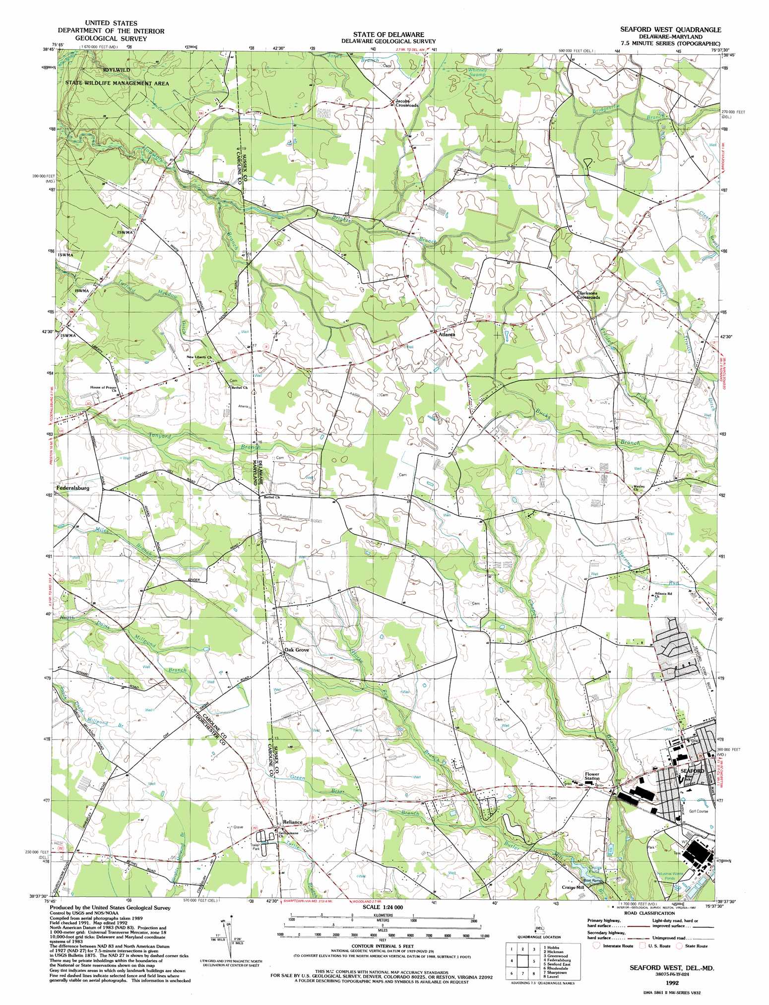
Seaford West Topo Map Delaware
To zoom in, hover over the map of Seaford West
USGS Topo Quad 38075f6 - 1:24,000 scale
| Topo Map Name: | Seaford West |
| USGS Topo Quad ID: | 38075f6 |
| Print Size: | ca. 21 1/4" wide x 27" high |
| Southeast Coordinates: | 38.625° N latitude / 75.625° W longitude |
| Map Center Coordinates: | 38.6875° N latitude / 75.6875° W longitude |
| U.S. States: | DE, MD |
| Filename: | o38075f6.jpg |
| Download Map JPG Image: | Seaford West topo map 1:24,000 scale |
| Map Type: | Topographic |
| Topo Series: | 7.5´ |
| Map Scale: | 1:24,000 |
| Source of Map Images: | United States Geological Survey (USGS) |
| Alternate Map Versions: |
Seaford West DE 1955, updated 1957 Download PDF Buy paper map Seaford West DE 1955, updated 1987 Download PDF Buy paper map Seaford West DE 1992, updated 1992 Download PDF Buy paper map Seaford West DE 2011 Download PDF Buy paper map Seaford West DE 2014 Download PDF Buy paper map Seaford West DE 2016 Download PDF Buy paper map |
1:24,000 Topo Quads surrounding Seaford West
Ridgely |
Denton |
Burrsville |
Harrington |
Milford |
Fowling Creek |
Hobbs |
Hickman |
Greenwood |
Ellendale |
Preston |
Federalsburg |
Seaford West |
Seaford East |
Georgetown |
East New Market |
Rhodesdale |
Sharptown |
Laurel |
Trap Pond |
Chicamacomico River |
Mardela Springs |
Hebron |
Delmar |
Pittsville |
> Back to 38075e1 at 1:100,000 scale
> Back to 38074a1 at 1:250,000 scale
> Back to U.S. Topo Maps home
Seaford West topo map: Gazetteer
Seaford West: Lakes
Craigs Pond elevation 2m 6′Seaford West: Parks
Kiwanis Park elevation 9m 29′Seaford West: Populated Places
Atlanta elevation 15m 49′Atlanta Estates elevation 10m 32′
Bossard Property elevation 10m 32′
Branchview elevation 9m 29′
Briar Hook elevation 13m 42′
Clarksons Crossroads elevation 15m 49′
Craigs Mill elevation 4m 13′
Devonshire Woods elevation 11m 36′
Heritage Village elevation 10m 32′
Jacobs Crossroads elevation 15m 49′
Oak Grove elevation 14m 45′
Reliance elevation 13m 42′
Richard Heights elevation 12m 39′
Ricland Heights elevation 12m 39′
Shuffelt Acres elevation 10m 32′
Woodland Station elevation 7m 22′
Seaford West: Streams
Brights Branch elevation 9m 29′Brights Branch elevation 9m 29′
Freidel Prong elevation 9m 29′
Gilbert Trivitts Ditch elevation 9m 29′
Green Briar Branch elevation 7m 22′
Horse Pen Branch elevation 7m 22′
Seaford West: Swamps
Whitney Swamp elevation 15m 49′Seaford West digital topo map on disk
Buy this Seaford West topo map showing relief, roads, GPS coordinates and other geographical features, as a high-resolution digital map file on DVD:
Atlantic Coast (NY, NJ, PA, DE, MD, VA, NC)
Buy digital topo maps: Atlantic Coast (NY, NJ, PA, DE, MD, VA, NC)
 map DVD")