Ruby Lee Reservoir Topo Map Colorado
To zoom in, hover over the map of Ruby Lee Reservoir
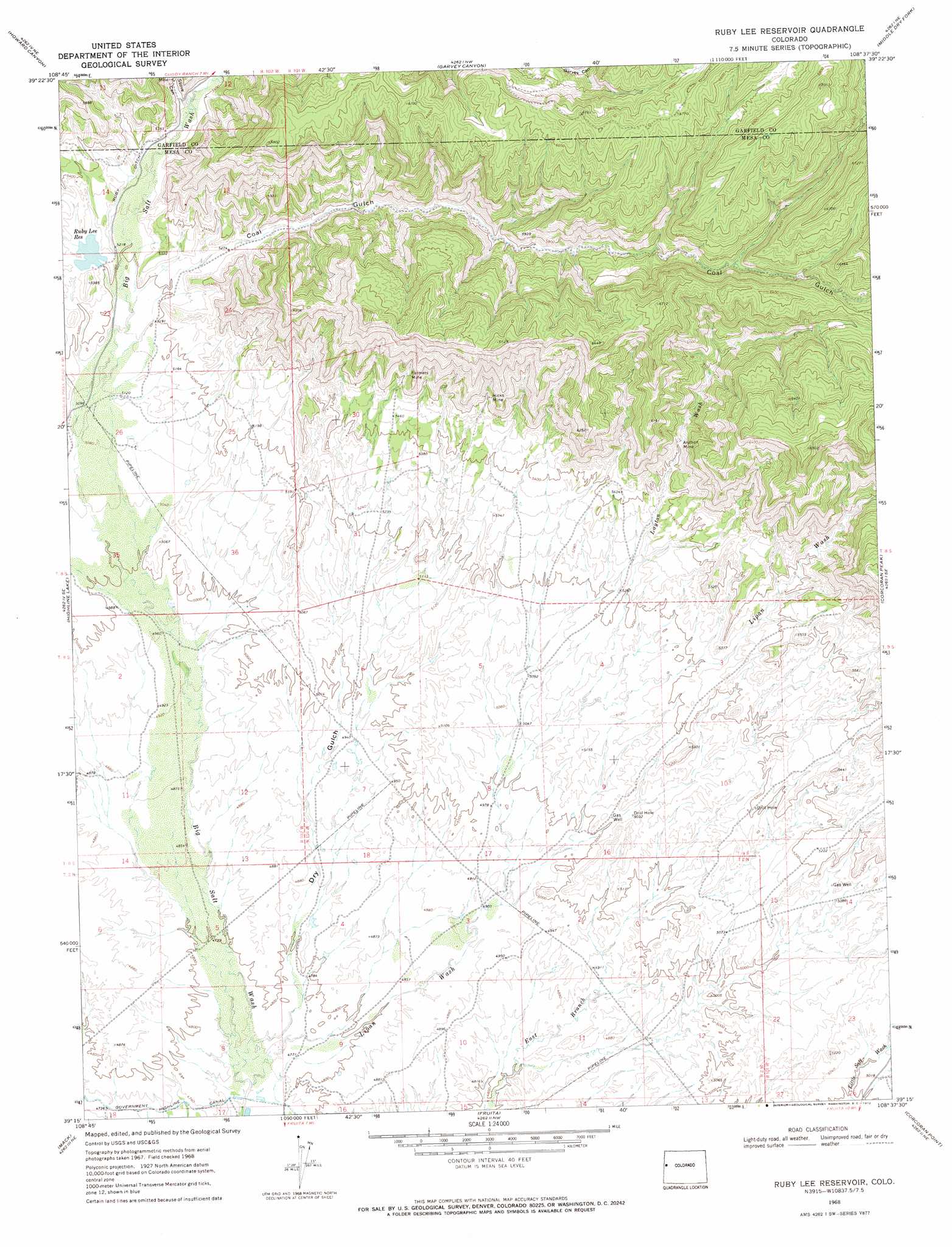
USGS Topo Quad 39108c6 - 1:24,000 scale
| Topo Map Name: | Ruby Lee Reservoir |
| USGS Topo Quad ID: | 39108c6 |
| Print Size: | ca. 21 1/4" wide x 27" high |
| Southeast Coordinates: | 39.25° N latitude / 108.625° W longitude |
| Map Center Coordinates: | 39.3125° N latitude / 108.6875° W longitude |
| U.S. State: | CO |
| Filename: | o39108c6.jpg |
| Download Map JPG Image: | Ruby Lee Reservoir topo map 1:24,000 scale |
| Map Type: | Topographic |
| Topo Series: | 7.5´ |
| Map Scale: | 1:24,000 |
| Source of Map Images: | United States Geological Survey (USGS) |
| Alternate Map Versions: |
Ruby Lee Reservoir CO 1968, updated 1972 Download PDF Buy paper map Ruby Lee Reservoir CO 2010 Download PDF Buy paper map Ruby Lee Reservoir CO 2013 Download PDF Buy paper map Ruby Lee Reservoir CO 2016 Download PDF Buy paper map |
1:24,000 Topo Quads surrounding Ruby Lee Reservoir
Baxter Pass |
Douglas Pass |
Calf Canyon |
Henderson Ridge |
Desert Gulch |
Carbonera |
Howard Canyon |
Garvey Canyon |
Middle Dry Fork |
The Saddle |
Badger Wash |
Highline Lake |
Ruby Lee Reservoir |
Corcoran Peak |
Winter Flats |
Ruby Canyon |
Mack |
Fruita |
Corcoran Point |
Round Mountain |
Sieber Canyon |
Battleship Rock |
Colorado National Monument |
Grand Junction |
Clifton |
> Back to 39108a1 at 1:100,000 scale
> Back to 39108a1 at 1:250,000 scale
> Back to U.S. Topo Maps home
Ruby Lee Reservoir topo map: Gazetteer
Ruby Lee Reservoir: Canals
Ruby Ditch elevation 1613m 5291′Ruby Lee Reservoir: Dams
Ruby Lee Dam elevation 1605m 5265′Ruby Lee Reservoir: Mines
Anchor Mine elevation 1674m 5492′Anchor Number One Mine elevation 1686m 5531′
Coal Gulch Coal Mine elevation 1674m 5492′
Farmer Coal Mine elevation 1720m 5643′
Farmers Mine elevation 1732m 5682′
Fruita Mine elevation 1787m 5862′
Garvey Mine elevation 1670m 5479′
Hicks Mine elevation 1708m 5603′
Kelehen Mine elevation 1695m 5561′
Lane Mine elevation 1706m 5597′
Nearing Mine elevation 1727m 5666′
Stove Canyon Mine elevation 1668m 5472′
Ruby Lee Reservoir: Reservoirs
Ruby Lee Reservoir elevation 1605m 5265′Ruby Lee Reservoir: Streams
Layton Wash elevation 1549m 5082′Lipan Wash elevation 1448m 4750′
Ruby Lee Reservoir: Valleys
Coal Gulch elevation 1584m 5196′Dry Gulch elevation 1452m 4763′
Stove Canyon elevation 1635m 5364′
Ruby Lee Reservoir digital topo map on disk
Buy this Ruby Lee Reservoir topo map showing relief, roads, GPS coordinates and other geographical features, as a high-resolution digital map file on DVD: