Rat Hole Ridge Topo Map Utah
To zoom in, hover over the map of Rat Hole Ridge
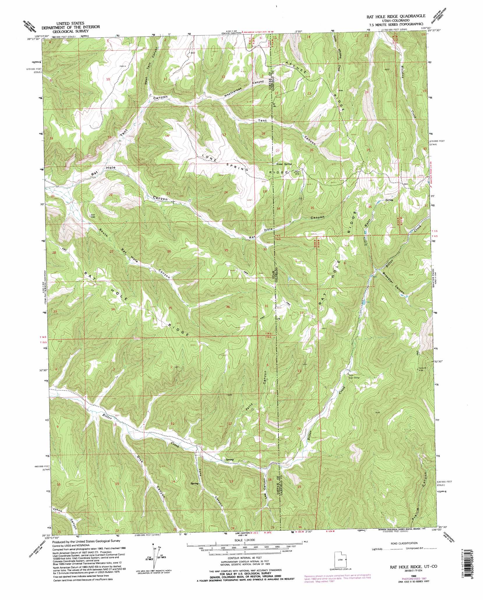
USGS Topo Quad 39109e1 - 1:24,000 scale
| Topo Map Name: | Rat Hole Ridge |
| USGS Topo Quad ID: | 39109e1 |
| Print Size: | ca. 21 1/4" wide x 27" high |
| Southeast Coordinates: | 39.5° N latitude / 109° W longitude |
| Map Center Coordinates: | 39.5625° N latitude / 109.0625° W longitude |
| U.S. States: | UT, CO |
| Filename: | o39109e1.jpg |
| Download Map JPG Image: | Rat Hole Ridge topo map 1:24,000 scale |
| Map Type: | Topographic |
| Topo Series: | 7.5´ |
| Map Scale: | 1:24,000 |
| Source of Map Images: | United States Geological Survey (USGS) |
| Alternate Map Versions: |
Rat Hole Ridge UT 1966, updated 1970 Download PDF Buy paper map Rat Hole Ridge UT 1966, updated 1987 Download PDF Buy paper map Rat Hole Ridge UT 1966, updated 1995 Download PDF Buy paper map Rat Hole Ridge UT 2011 Download PDF Buy paper map Rat Hole Ridge UT 2014 Download PDF Buy paper map |
1:24,000 Topo Quads surrounding Rat Hole Ridge
Archy Bench Se |
Rainbow |
Dragon |
Texas Creek |
Texas Mountain |
Cooper Canyon |
Burnt Timber Canyon |
Davis Canyon |
East Evacuation Creek |
Big Foundation Creek |
Seep Canyon |
Tom Patterson Canyon |
Rat Hole Ridge |
Baxter Pass |
Douglas Pass |
P R Spring |
San Arroyo Ridge |
Jim Canyon |
Carbonera |
Howard Canyon |
Dry Canyon |
Bryson Canyon |
Bar X Wash |
Badger Wash |
Highline Lake |
> Back to 39109e1 at 1:100,000 scale
> Back to 39108a1 at 1:250,000 scale
> Back to U.S. Topo Maps home
Rat Hole Ridge topo map: Gazetteer
Rat Hole Ridge: Ridges
Lone Spring Ridge elevation 2578m 8458′Lone Spring Ridge elevation 2515m 8251′
Rat Hole Ridge elevation 2543m 8343′
Rat Hole Ridge: Springs
Lone Spring elevation 2500m 8202′Rat Hole Ridge: Streams
Little Water elevation 2399m 7870′Rat Hole Ridge: Valleys
Brewster Canyon elevation 2399m 7870′Dick Canyon elevation 2093m 6866′
Fatty Canyon elevation 2161m 7089′
Lee Canyon elevation 2190m 7185′
South Rat Hole Canyon elevation 2063m 6768′
South Rat Hole Canyon elevation 2062m 6765′
Tent Canyon elevation 2101m 6893′
Tent Canyon elevation 2088m 6850′
Tony Canyon elevation 2135m 7004′
Weatherbee Canyon elevation 2283m 7490′
Weatherbee Canyon elevation 2267m 7437′
West Tent Canyon elevation 2194m 7198′
Rat Hole Ridge digital topo map on disk
Buy this Rat Hole Ridge topo map showing relief, roads, GPS coordinates and other geographical features, as a high-resolution digital map file on DVD: