Big Joe Basin Topo Map Colorado
To zoom in, hover over the map of Big Joe Basin
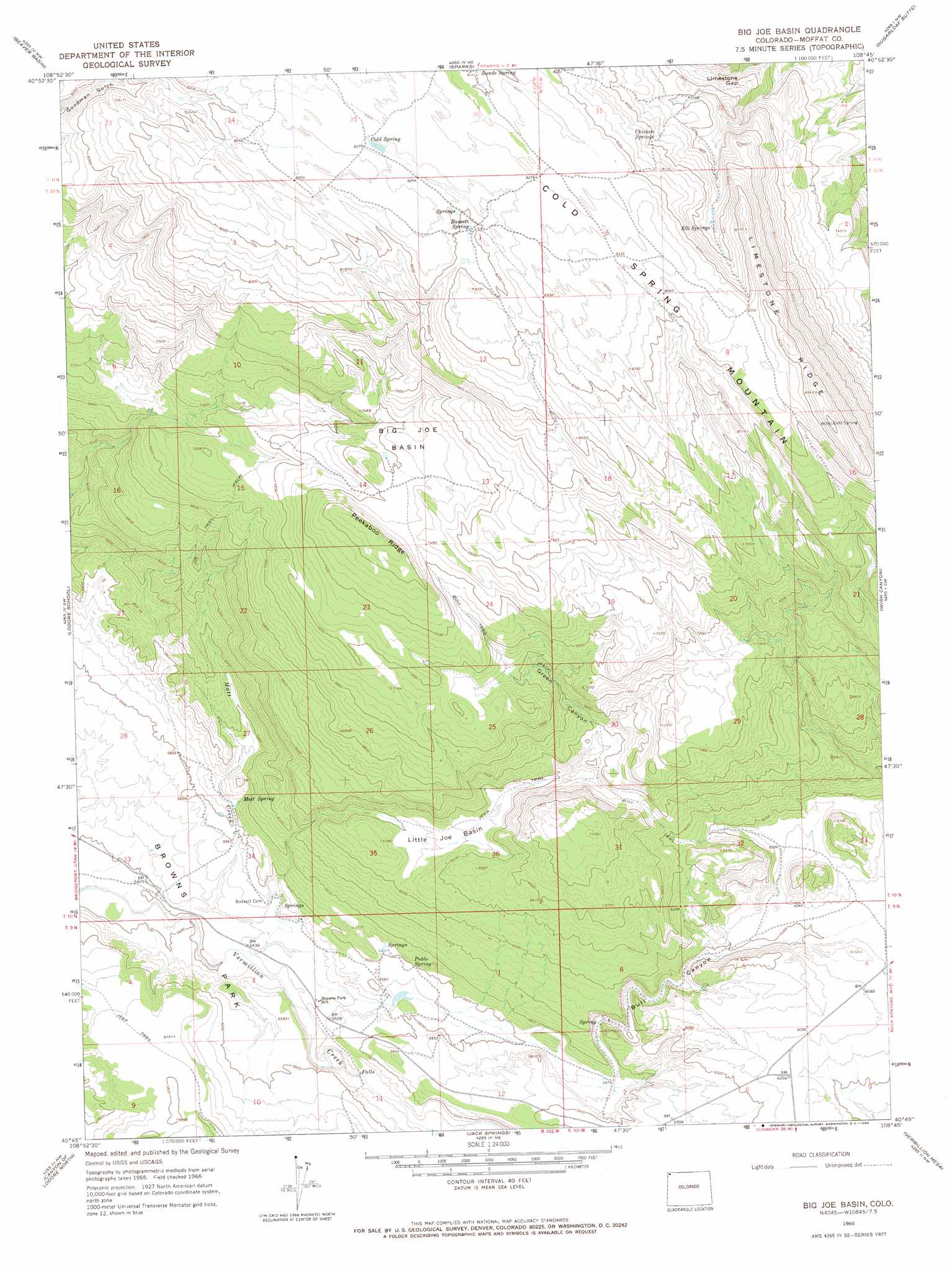
USGS Topo Quad 40108g7 - 1:24,000 scale
| Topo Map Name: | Big Joe Basin |
| USGS Topo Quad ID: | 40108g7 |
| Print Size: | ca. 21 1/4" wide x 27" high |
| Southeast Coordinates: | 40.75° N latitude / 108.75° W longitude |
| Map Center Coordinates: | 40.8125° N latitude / 108.8125° W longitude |
| U.S. State: | CO |
| Filename: | o40108g7.jpg |
| Download Map JPG Image: | Big Joe Basin topo map 1:24,000 scale |
| Map Type: | Topographic |
| Topo Series: | 7.5´ |
| Map Scale: | 1:24,000 |
| Source of Map Images: | United States Geological Survey (USGS) |
| Alternate Map Versions: |
Big Joe Basin CO 1966, updated 1969 Download PDF Buy paper map Big Joe Basin CO 2010 Download PDF Buy paper map Big Joe Basin CO 2013 Download PDF Buy paper map Big Joe Basin CO 2016 Download PDF Buy paper map |
1:24,000 Topo Quads surrounding Big Joe Basin
Red Creek Ranch |
Four J Rim |
Scrivner Butte |
Chicken Creek Sw |
Chicken Creek Se |
Willow Creek Butte |
Beaver Basin |
Sparks |
Sugarloaf Butte |
Hiawatha |
Swallow Canyon |
Lodore School |
Big Joe Basin |
Irish Canyon |
G Spring |
Hoy Mountain |
Canyon Of Lodore North |
Jack Springs |
Vermillion Mesa |
Sheephead Basin |
Jones Hole |
Canyon Of Lodore South |
Zenobia Peak |
Greystone |
Limestone Hill |
> Back to 40108e1 at 1:100,000 scale
> Back to 40108a1 at 1:250,000 scale
> Back to U.S. Topo Maps home
Big Joe Basin topo map: Gazetteer
Big Joe Basin: Basins
Big Joe Basin elevation 2271m 7450′Little Joe Basin elevation 1912m 6272′
Big Joe Basin: Dams
Basset Number 2 Dam elevation 1689m 5541′Big Joe Basin: Gaps
Limestone Gap elevation 2327m 7634′Big Joe Basin: Mines
Airborne Anomaly 56-11 Mine elevation 1984m 6509′Big Joe Basin: Reservoirs
Basset Reservoir Number 2 elevation 1689m 5541′Big Joe Basin: Ridges
Limestone Ridge elevation 2584m 8477′Peekaboo Ridge elevation 2354m 7723′
Big Joe Basin: Springs
Bassett Spring elevation 2501m 8205′Chicken Spring elevation 2424m 7952′
Cold Spring elevation 2525m 8284′
Elk Springs elevation 2416m 7926′
Pablo Spring elevation 1719m 5639′
Strong Spring elevation 2270m 7447′
Swede Spring elevation 2500m 8202′
Big Joe Basin: Streams
Matt Creek elevation 1648m 5406′Big Joe Basin: Trails
Bull Trail elevation 2063m 6768′Joe Trail elevation 1967m 6453′
Big Joe Basin: Valleys
Bull Canyon elevation 1732m 5682′Green Canyon elevation 1998m 6555′
Big Joe Basin digital topo map on disk
Buy this Big Joe Basin topo map showing relief, roads, GPS coordinates and other geographical features, as a high-resolution digital map file on DVD: