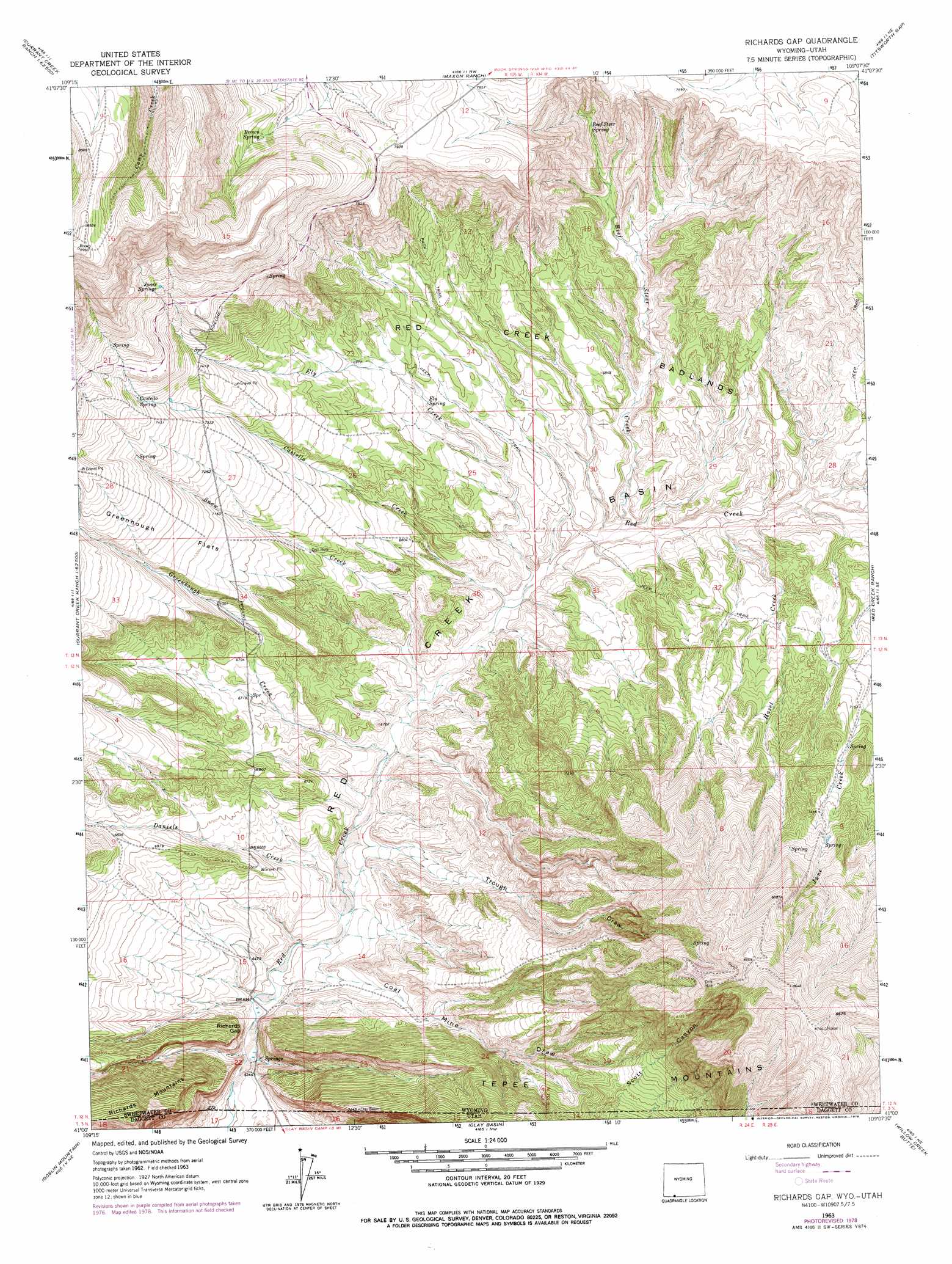
Richards Gap Topo Map Wyoming
To zoom in, hover over the map of Richards Gap
USGS Topo Quad 41109a2 - 1:24,000 scale
| Topo Map Name: | Richards Gap |
| USGS Topo Quad ID: | 41109a2 |
| Print Size: | ca. 21 1/4" wide x 27" high |
| Southeast Coordinates: | 41° N latitude / 109.125° W longitude |
| Map Center Coordinates: | 41.0625° N latitude / 109.1875° W longitude |
| U.S. States: | WY, UT |
| Filename: | o41109a2.jpg |
| Download Map JPG Image: | Richards Gap topo map 1:24,000 scale |
| Map Type: | Topographic |
| Topo Series: | 7.5´ |
| Map Scale: | 1:24,000 |
| Source of Map Images: | United States Geological Survey (USGS) |
| Alternate Map Versions: |
Richards Gap WY 1963, updated 1966 Download PDF Buy paper map Richards Gap WY 1963, updated 1979 Download PDF Buy paper map Richards Gap WY 1963, updated 1979 Download PDF Buy paper map Richards Gap WY 2011 Download PDF Buy paper map Richards Gap WY 2012 Download PDF Buy paper map Richards Gap WY 2015 Download PDF Buy paper map |
1:24,000 Topo Quads surrounding Richards Gap
Sage Creek Basin |
Firehole Basin |
Earnest Butte |
South Baxter |
Mud Springs Ranch |
Sugarloaf Basin |
Big Ridge |
Maxon Ranch |
Titsworth Gap |
Potter Mountain |
Minnies Gap |
Hawks Nest |
Richards Gap |
Red Creek Ranch |
Four J Rim |
Dutch John |
Goslin Mountain |
Clay Basin |
Willow Creek Butte |
Beaver Basin |
Mount Lena |
Jackson Draw |
Warren Draw |
Swallow Canyon |
Lodore School |
> Back to 41109a1 at 1:100,000 scale
> Back to 41108a1 at 1:250,000 scale
> Back to U.S. Topo Maps home
Richards Gap topo map: Gazetteer
Richards Gap: Areas
Red Creek Badlands elevation 2081m 6827′Richards Gap: Basins
Red Creek Basin elevation 2050m 6725′Richards Gap: Flats
Greenhough Flats elevation 2225m 7299′Richards Gap: Gaps
Richards Gap elevation 1933m 6341′Richards Gap: Populated Places
Greenhough Place elevation 2277m 7470′Richards Gap: Ranges
Tepee Mountains elevation 2237m 7339′Richards Gap: Springs
Beef Steer Spring elevation 2195m 7201′Brown Spring elevation 2403m 7883′
Castello Spring elevation 2294m 7526′
Ely Spring elevation 2093m 6866′
Jones Springs elevation 2398m 7867′
Richards Gap: Streams
Beef Steer Creek elevation 2027m 6650′Castello Creek elevation 2008m 6587′
Daniels Creek elevation 1961m 6433′
Ely Creek elevation 2008m 6587′
Greenhough Creek elevation 1980m 6496′
Hazel Creek elevation 2037m 6683′
Snow Creek elevation 1990m 6528′
Richards Gap: Valleys
Coal Mine Draw elevation 1946m 6384′Trough Draw elevation 1970m 6463′
Richards Gap digital topo map on disk
Buy this Richards Gap topo map showing relief, roads, GPS coordinates and other geographical features, as a high-resolution digital map file on DVD: