Little Glass Mountain Topo Map California
To zoom in, hover over the map of Little Glass Mountain
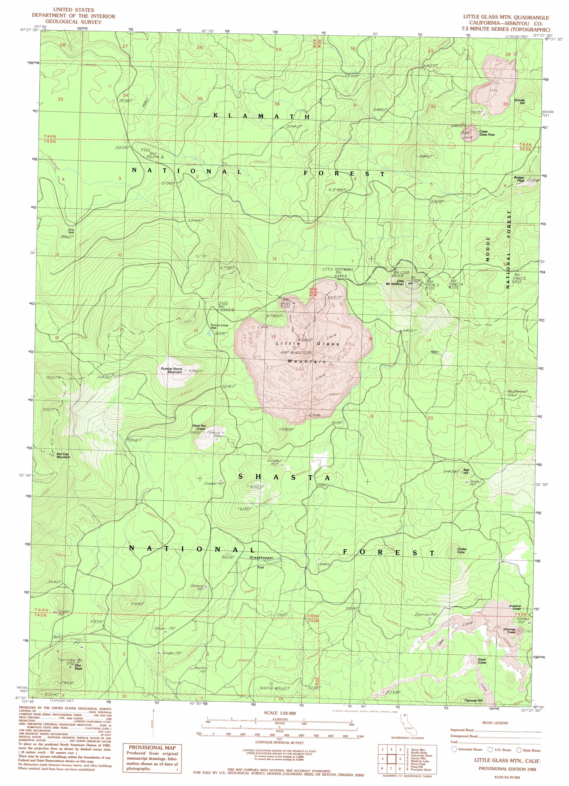
USGS Topo Quad 41121e6 - 1:24,000 scale
| Topo Map Name: | Little Glass Mountain |
| USGS Topo Quad ID: | 41121e6 |
| Print Size: | ca. 21 1/4" wide x 27" high |
| Southeast Coordinates: | 41.5° N latitude / 121.625° W longitude |
| Map Center Coordinates: | 41.5625° N latitude / 121.6875° W longitude |
| U.S. State: | CA |
| Filename: | o41121e6.jpg |
| Download Map JPG Image: | Little Glass Mountain topo map 1:24,000 scale |
| Map Type: | Topographic |
| Topo Series: | 7.5´ |
| Map Scale: | 1:24,000 |
| Source of Map Images: | United States Geological Survey (USGS) |
| Alternate Map Versions: |
Little Glass Mountain CA 1988, updated 1988 Download PDF Buy paper map Little Glass Mountain CA 1998, updated 2003 Download PDF Buy paper map Little Glass Mountain CA 2012 Download PDF Buy paper map Little Glass Mountain CA 2015 Download PDF Buy paper map |
| FStopo: | US Forest Service topo Little Glass Mountain is available: Download FStopo PDF Download FStopo TIF |
1:24,000 Topo Quads surrounding Little Glass Mountain
Sheep Mountain |
Red Rock Lakes |
Mount Dome |
Captain Jacks Stronghold |
The Panhandle |
Bray |
Sharp Mountain |
Bonita Butte |
Schonchin Butte |
Caldwell Butte |
Tennant |
Garner Mountain |
Little Glass Mountain |
Medicine Lake |
West Of Kephart |
Rainbow Mountain |
Horse Peak |
Snag Hill |
Porcupine Butte |
Border Mountain |
Kinyon |
Bartle |
Hambone |
Indian Spring Mountain |
Whitehorse |
> Back to 41121e1 at 1:100,000 scale
> Back to 41120a1 at 1:250,000 scale
> Back to U.S. Topo Maps home
Little Glass Mountain topo map: Gazetteer
Little Glass Mountain: Craters
Chimney Crater elevation 1784m 5853′Crater Glass Flow elevation 2151m 7057′
Giant Crater elevation 1704m 5590′
Paint Pot Crater elevation 1911m 6269′
Shastine Crater elevation 1779m 5836′
Little Glass Mountain: Dams
Waste Water Ponds 647 Dam elevation 2087m 6847′Little Glass Mountain: Flats
Grasshopper Flat elevation 1714m 5623′Little Glass Mountain: Lavas
Tilted Rock Lava Flow elevation 1791m 5875′Little Glass Mountain: Summits
Badger Peak elevation 2236m 7335′Buck Hill elevation 1790m 5872′
Cinder Cone elevation 1890m 6200′
Doe Peak elevation 1854m 6082′
Fawn Hill elevation 1804m 5918′
Grouse Hill elevation 2142m 7027′
Hopper Hill elevation 1784m 5853′
Little Glass Mountain elevation 2073m 6801′
Little Mount Hoffman elevation 2197m 7208′
Pumice Stone Mountain elevation 2120m 6955′
Red Cap Mountain elevation 2147m 7043′
Red Hill elevation 1956m 6417′
Little Glass Mountain: Wells
Bray Well elevation 1727m 5666′Pumice Stone Well elevation 1952m 6404′
Little Glass Mountain digital topo map on disk
Buy this Little Glass Mountain topo map showing relief, roads, GPS coordinates and other geographical features, as a high-resolution digital map file on DVD: