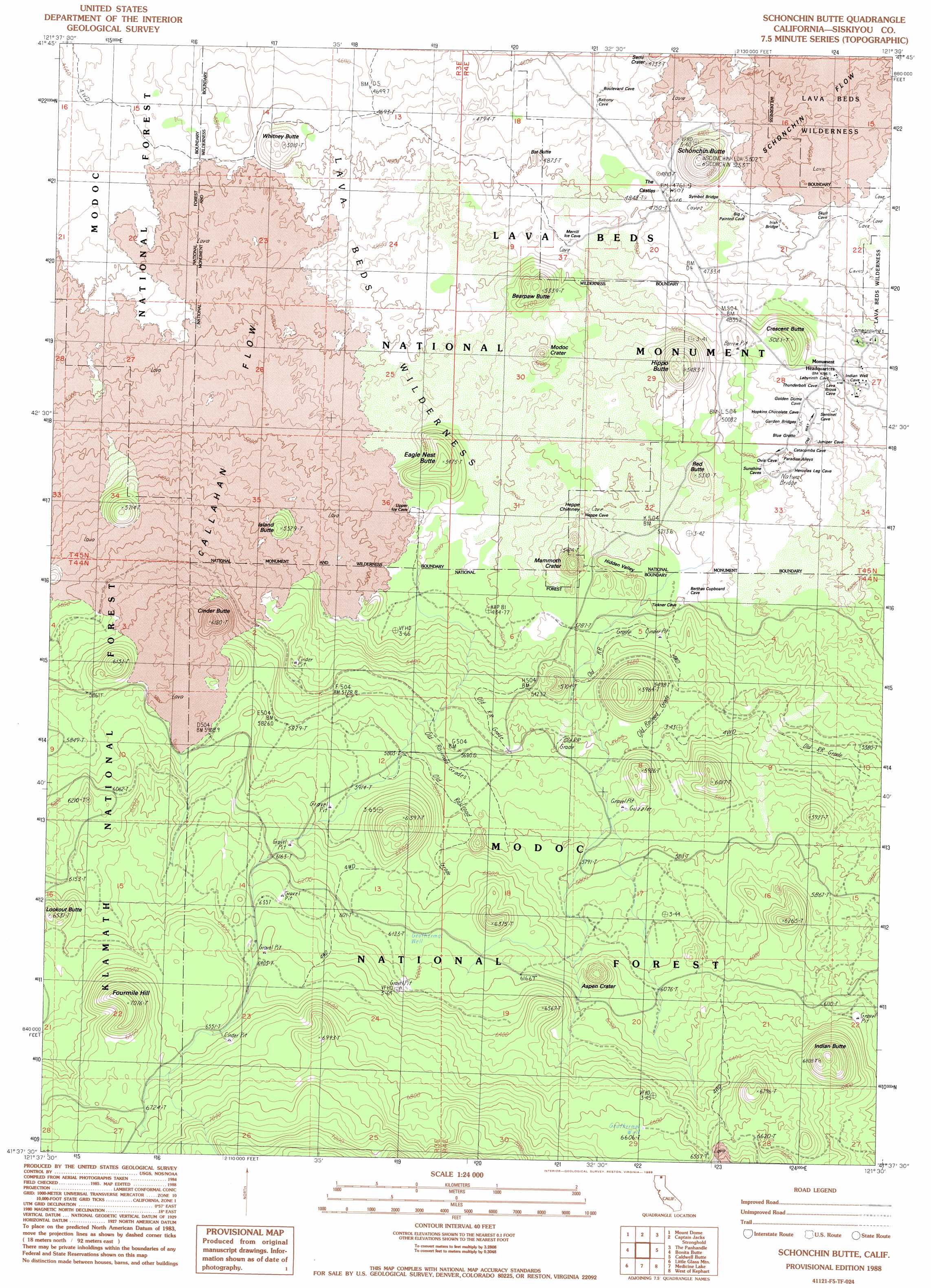
Schonchin Butte Topo Map California
To zoom in, hover over the map of Schonchin Butte
USGS Topo Quad 41121f5 - 1:24,000 scale
| Topo Map Name: | Schonchin Butte |
| USGS Topo Quad ID: | 41121f5 |
| Print Size: | ca. 21 1/4" wide x 27" high |
| Southeast Coordinates: | 41.625° N latitude / 121.5° W longitude |
| Map Center Coordinates: | 41.6875° N latitude / 121.5625° W longitude |
| U.S. State: | CA |
| Filename: | o41121f5.jpg |
| Download Map JPG Image: | Schonchin Butte topo map 1:24,000 scale |
| Map Type: | Topographic |
| Topo Series: | 7.5´ |
| Map Scale: | 1:24,000 |
| Source of Map Images: | United States Geological Survey (USGS) |
| Alternate Map Versions: |
Medicine Lake NE CA 1975, updated 1979 Download PDF Buy paper map Schonchin Butte CA 1988, updated 1988 Download PDF Buy paper map Schonchin Butte CA 1993, updated 1996 Download PDF Buy paper map Schonchin Butte CA 2012 Download PDF Buy paper map Schonchin Butte CA 2015 Download PDF Buy paper map |
| FStopo: | US Forest Service topo Schonchin Butte is available: Download FStopo PDF Download FStopo TIF |
1:24,000 Topo Quads surrounding Schonchin Butte
Sheepy Lake |
Lower Klamath Lake |
Hatfield |
Tulelake |
Newell |
Red Rock Lakes |
Mount Dome |
Captain Jacks Stronghold |
The Panhandle |
Copic |
Sharp Mountain |
Bonita Butte |
Schonchin Butte |
Caldwell Butte |
Perez |
Garner Mountain |
Little Glass Mountain |
Medicine Lake |
West Of Kephart |
Kephart |
Horse Peak |
Snag Hill |
Porcupine Butte |
Border Mountain |
Hollenbeck |
> Back to 41121e1 at 1:100,000 scale
> Back to 41120a1 at 1:250,000 scale
> Back to U.S. Topo Maps home
Schonchin Butte topo map: Gazetteer
Schonchin Butte: Arches
Garden Bridges elevation 1511m 4957′Heppe Bridge elevation 1587m 5206′
Irish Bridge elevation 1405m 4609′
Merril Natural Bridge elevation 1494m 4901′
Ovis Bridge elevation 1537m 5042′
Peninsula Bridge elevation 1361m 4465′
Symbol Bridge elevation 1428m 4685′
Schonchin Butte: Craters
Aspen Crater elevation 1775m 5823′Mammoth Crater elevation 1555m 5101′
Modoc Crater elevation 1567m 5141′
Semi Crater elevation 1434m 4704′
Schonchin Butte: Lavas
Callahan Flow elevation 1586m 5203′Schonchin Butte: Pillars
Heppe Chimney elevation 1606m 5269′The Castles elevation 1475m 4839′
Tickner Chimneys elevation 1610m 5282′
Schonchin Butte: Summits
Bat Butte elevation 1455m 4773′Bearpaw Butte elevation 1595m 5232′
Cinder Butte elevation 1813m 5948′
Crescent Butte elevation 1526m 5006′
Eagle Nest Butte elevation 1641m 5383′
Fourmile Hill elevation 2115m 6938′
Hippo Butte elevation 1657m 5436′
Indian Butte elevation 2037m 6683′
Island Butte elevation 1648m 5406′
Red Butte elevation 1614m 5295′
Schonchin Butte elevation 1597m 5239′
Whitney Butte elevation 1513m 4963′
Schonchin Butte: Trails
Big Nasty Trail elevation 1636m 5367′Bunchgrass Trail elevation 1416m 4645′
Missing Link Trail elevation 1413m 4635′
Whitney Butte Trail elevation 1453m 4767′
Schonchin Butte: Valleys
Hidden Valley elevation 1582m 5190′Schonchin Butte digital topo map on disk
Buy this Schonchin Butte topo map showing relief, roads, GPS coordinates and other geographical features, as a high-resolution digital map file on DVD: