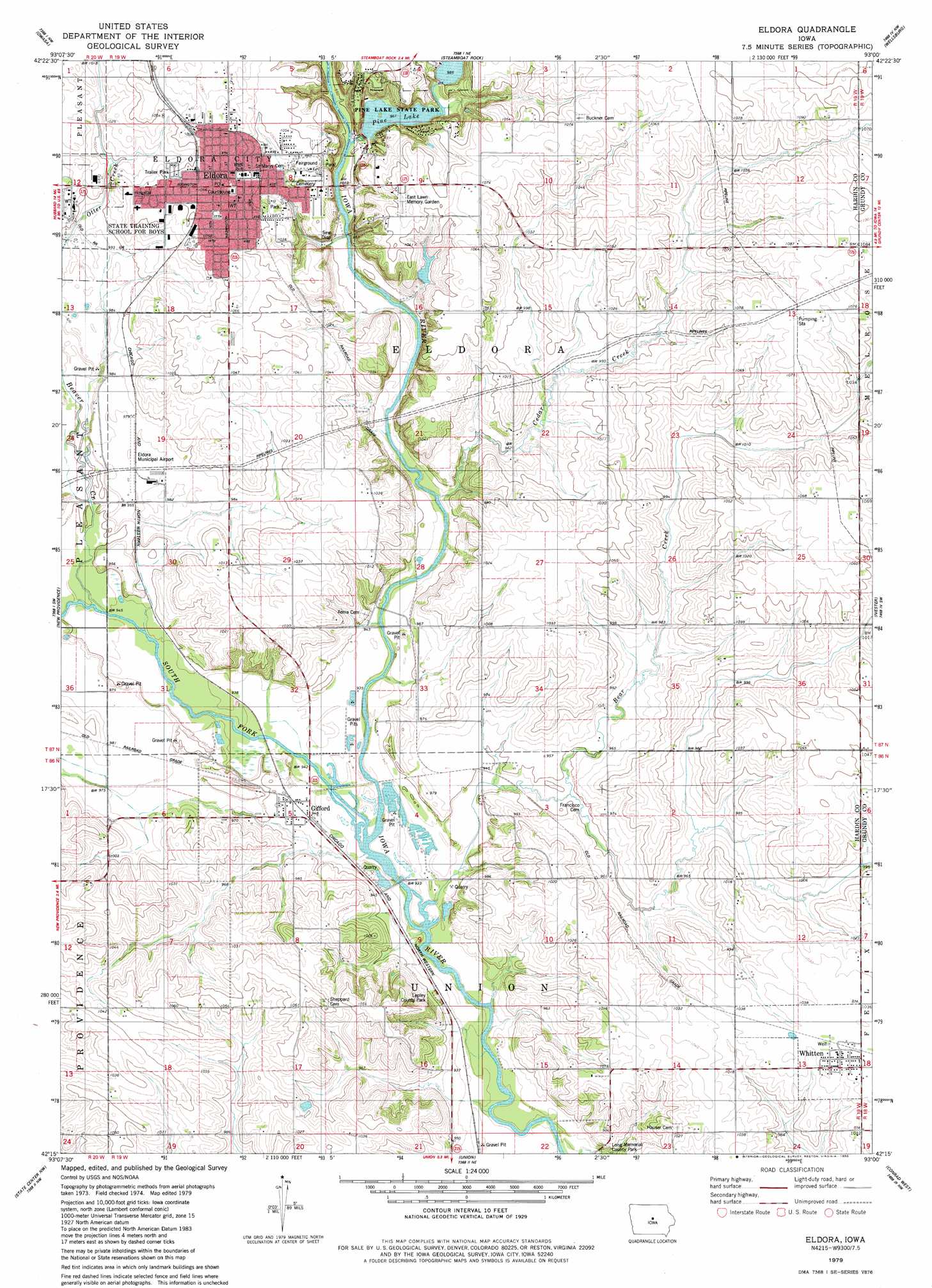
Eldora Topo Map Iowa
To zoom in, hover over the map of Eldora
USGS Topo Quad 42093c1 - 1:24,000 scale
| Topo Map Name: | Eldora |
| USGS Topo Quad ID: | 42093c1 |
| Print Size: | ca. 21 1/4" wide x 27" high |
| Southeast Coordinates: | 42.25° N latitude / 93° W longitude |
| Map Center Coordinates: | 42.3125° N latitude / 93.0625° W longitude |
| U.S. State: | IA |
| Filename: | o42093c1.jpg |
| Download Map JPG Image: | Eldora topo map 1:24,000 scale |
| Map Type: | Topographic |
| Topo Series: | 7.5´ |
| Map Scale: | 1:24,000 |
| Source of Map Images: | United States Geological Survey (USGS) |
| Alternate Map Versions: |
Eldora IA 2010 Download PDF Buy paper map Eldora IA 2013 Download PDF Buy paper map Eldora IA 2015 Download PDF Buy paper map |
1:24,000 Topo Quads surrounding Eldora
Iowa Falls West |
Iowa Falls East |
Ackley |
Aplington |
Parkersburg |
Buckeye East |
Owasa |
Steamboat Rock |
Wellsburg |
Holland |
Hubbard |
New Providence |
Eldora |
Ivester |
Grundy Center |
Zearing |
State Center Nw |
Union |
Conrad West |
Conrad East |
Colo |
State Center |
La Moille |
Marshalltown |
Le Grand |
> Back to 42093a1 at 1:100,000 scale
> Back to 42092a1 at 1:250,000 scale
> Back to U.S. Topo Maps home
Eldora topo map: Gazetteer
Eldora: Airports
Eldora Municipal Airport elevation 298m 977′Eldora: Dams
Upper Pine Lake Dam elevation 299m 980′Eldora: Parks
Civil War Statue elevation 332m 1089′David Bates Memorial Park elevation 280m 918′
Edgington Land Patent Historical Marker elevation 332m 1089′
Eldora City Park elevation 314m 1030′
Eldora Municipal Park elevation 315m 1033′
Lepley County Park elevation 287m 941′
Memorial to Eldora Pioneers Historical Marker elevation 332m 1089′
Pine Lake State Park elevation 297m 974′
Eldora: Populated Places
Eldora elevation 331m 1085′Gifford elevation 288m 944′
Secor (historical) elevation 288m 944′
Whitten elevation 315m 1033′
Xenia elevation 295m 967′
Eldora: Post Offices
Delanti Post Office (historical) elevation 288m 944′Eldora Junction Post Office (historical) elevation 293m 961′
Eldora Post Office elevation 329m 1079′
Gifford Post Office (historical) elevation 288m 944′
Secor Post Office (historical) elevation 288m 944′
Whitten Post Office elevation 315m 1033′
Xenia Post Office (historical) elevation 288m 944′
Eldora: Reservoirs
Pine Lake elevation 301m 987′Upper Pine Lake elevation 299m 980′
Eldora: Streams
Bear Creek elevation 280m 918′Beaver Creek elevation 286m 938′
Cedar Creek elevation 283m 928′
Pine Creek elevation 289m 948′
South Fork Iowa River elevation 280m 918′
Eldora digital topo map on disk
Buy this Eldora topo map showing relief, roads, GPS coordinates and other geographical features, as a high-resolution digital map file on DVD: