Dickshooter Reservoir Topo Map Idaho
To zoom in, hover over the map of Dickshooter Reservoir
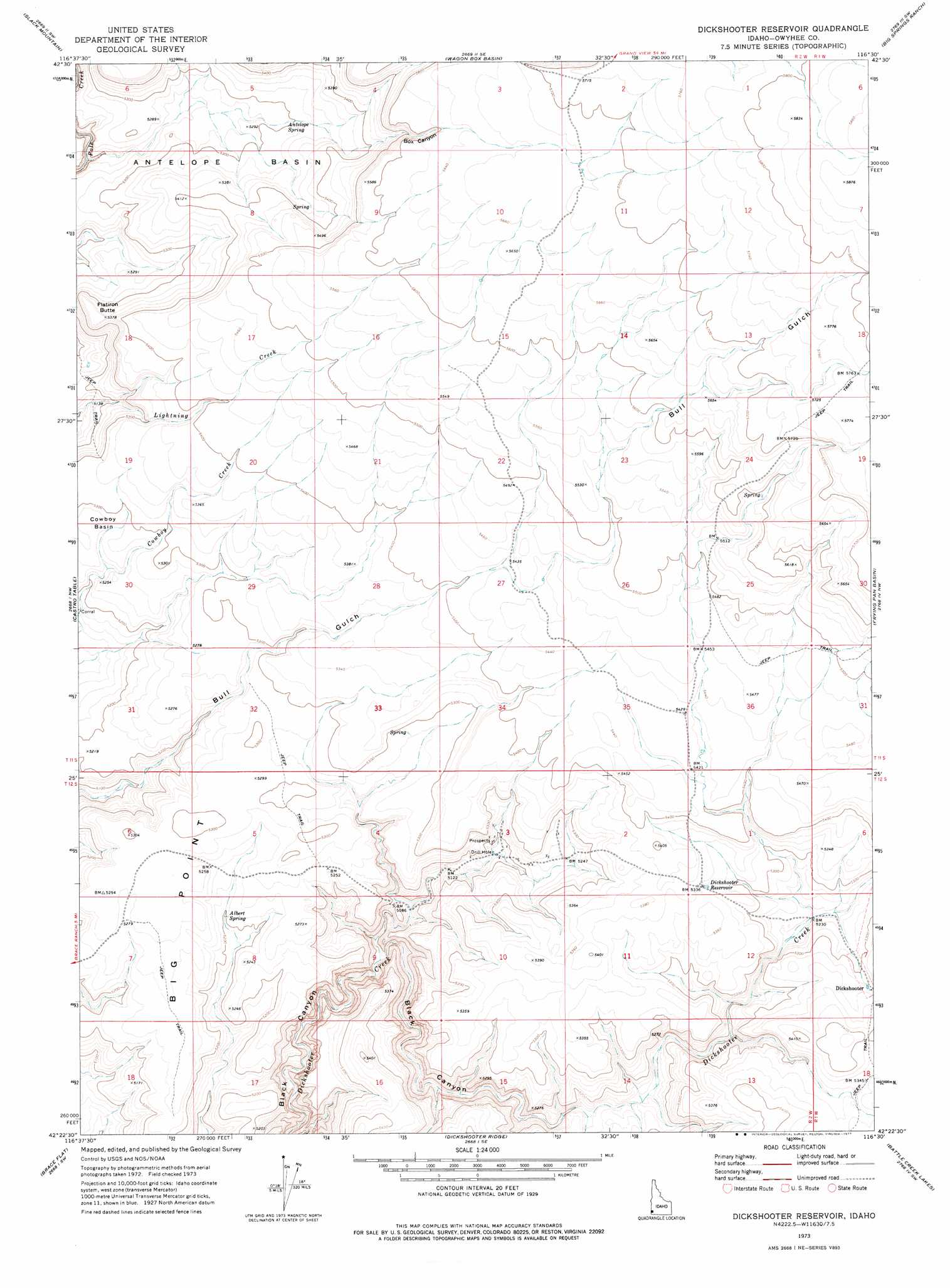
USGS Topo Quad 42116d5 - 1:24,000 scale
| Topo Map Name: | Dickshooter Reservoir |
| USGS Topo Quad ID: | 42116d5 |
| Print Size: | ca. 21 1/4" wide x 27" high |
| Southeast Coordinates: | 42.375° N latitude / 116.5° W longitude |
| Map Center Coordinates: | 42.4375° N latitude / 116.5625° W longitude |
| U.S. State: | ID |
| Filename: | o42116d5.jpg |
| Download Map JPG Image: | Dickshooter Reservoir topo map 1:24,000 scale |
| Map Type: | Topographic |
| Topo Series: | 7.5´ |
| Map Scale: | 1:24,000 |
| Source of Map Images: | United States Geological Survey (USGS) |
| Alternate Map Versions: |
Dickshooter Reservoir ID 1973, updated 1977 Download PDF Buy paper map Dickshooter Reservoir ID 2010 Download PDF Buy paper map Dickshooter Reservoir ID 2013 Download PDF Buy paper map |
1:24,000 Topo Quads surrounding Dickshooter Reservoir
Indian Meadows |
Wickiup Creek |
Hurry Up Creek |
Clover Mountain |
Snow Creek |
Pleasant Valley |
Slack Mountain |
Wagon Box Basin |
Big Springs Ranch |
Crab Spring Butte |
Smith Creek |
Castro Table |
Dickshooter Reservoir |
Frying Pan Basin |
Lost Valley |
Red Basin |
Brace Flat |
Dickshooter Ridge |
Battle Creek Lakes |
Shoofly Springs |
Grassy Ridge |
Piute Basin West |
Piute Basin East |
Jarvis Pasture |
Ross Lake |
> Back to 42116a1 at 1:100,000 scale
> Back to 42116a1 at 1:250,000 scale
> Back to U.S. Topo Maps home
Dickshooter Reservoir topo map: Gazetteer
Dickshooter Reservoir: Basins
Antelope Basin elevation 1618m 5308′Cowboy Basin elevation 1608m 5275′
Dickshooter Reservoir: Populated Places
Dickshooter elevation 1625m 5331′Dickshooter Reservoir: Reservoirs
Dickshooter Reservoir elevation 1628m 5341′Dickshooter Reservoir: Ridges
Big Point elevation 1611m 5285′Dickshooter Reservoir: Springs
Albert Spring elevation 1586m 5203′Antelope Spring elevation 1615m 5298′
Dickshooter Reservoir: Summits
Flatiron Butte elevation 1638m 5374′Dickshooter Reservoir: Valleys
Box Canyon elevation 1651m 5416′Dickshooter Reservoir digital topo map on disk
Buy this Dickshooter Reservoir topo map showing relief, roads, GPS coordinates and other geographical features, as a high-resolution digital map file on DVD: