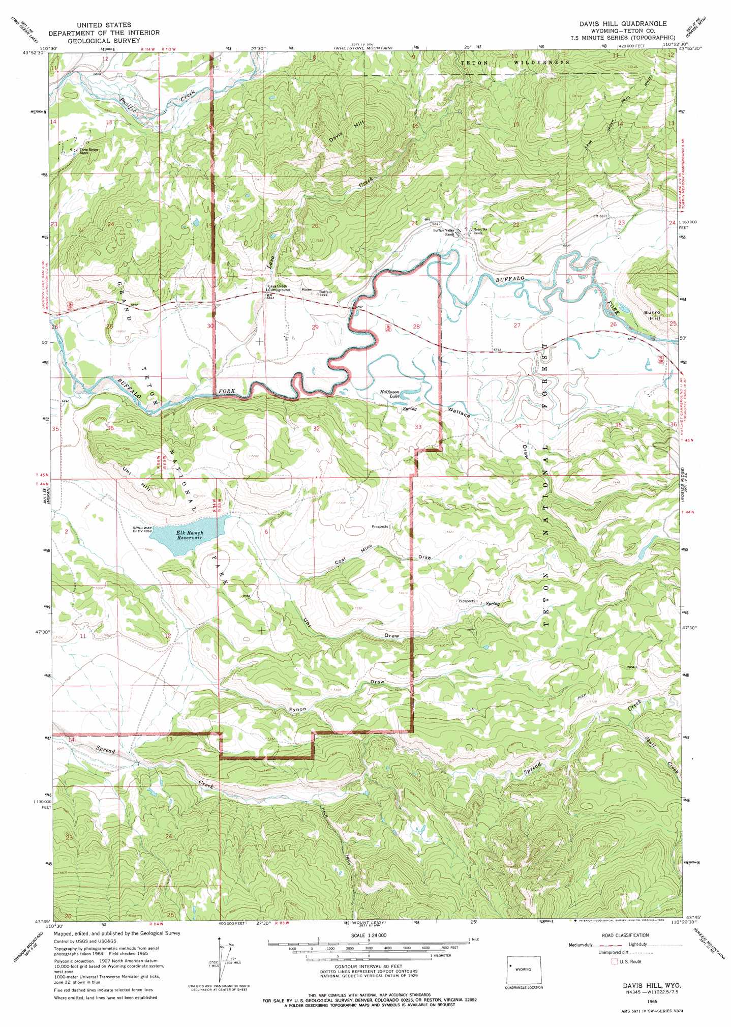
Davis Hill Topo Map Wyoming
To zoom in, hover over the map of Davis Hill
USGS Topo Quad 43110g4 - 1:24,000 scale
| Topo Map Name: | Davis Hill |
| USGS Topo Quad ID: | 43110g4 |
| Print Size: | ca. 21 1/4" wide x 27" high |
| Southeast Coordinates: | 43.75° N latitude / 110.375° W longitude |
| Map Center Coordinates: | 43.8125° N latitude / 110.4375° W longitude |
| U.S. State: | WY |
| Filename: | o43110g4.jpg |
| Download Map JPG Image: | Davis Hill topo map 1:24,000 scale |
| Map Type: | Topographic |
| Topo Series: | 7.5´ |
| Map Scale: | 1:24,000 |
| Source of Map Images: | United States Geological Survey (USGS) |
| Alternate Map Versions: |
Davis Hill WY 1965, updated 1968 Download PDF Buy paper map Davis Hill WY 1965, updated 1978 Download PDF Buy paper map Davis Hill WY 1965, updated 1978 Download PDF Buy paper map Davis Hill WY 1996, updated 1998 Download PDF Buy paper map Davis Hill WY 2012 Download PDF Buy paper map Davis Hill WY 2015 Download PDF Buy paper map |
| FStopo: | US Forest Service topo Davis Hill is available: Download FStopo PDF Download FStopo TIF |
1:24,000 Topo Quads surrounding Davis Hill
Flagg Ranch |
Huckleberry Mountain |
Bobcat Ridge |
Gravel Peak |
Two Ocean Pass |
Colter Bay |
Two Ocean Lake |
Whetstone Mountain |
Hunter Mountain |
Joy Peak |
Jenny Lake |
Moran |
Davis Hill |
Rosies Ridge |
Angle Mountain |
Moose |
Shadow Mountain |
Mount Leidy |
Green Mountain |
Tripod Peak |
Gros Ventre Junction |
Blue Miner Lake |
Grizzly Lake |
Upper Slide Lake |
Burnt Mountain |
> Back to 43110e1 at 1:100,000 scale
> Back to 43110a1 at 1:250,000 scale
> Back to U.S. Topo Maps home
Davis Hill topo map: Gazetteer
Davis Hill: Dams
Porter Dam elevation 2293m 7522′Uhl Dam elevation 2095m 6873′
Davis Hill: Lakes
Halfmoon Lake elevation 2065m 6774′Davis Hill: Mines
Johnson Mine elevation 2124m 6968′Davis Hill: Reservoirs
Elk Ranch Reservoir elevation 2094m 6870′Porter Reservoir elevation 2293m 7522′
Uhl Reservoir elevation 2095m 6873′
Wallace Draw-Reservoir elevation 2281m 7483′
Davis Hill: Streams
Coal Creek elevation 2147m 7043′Lava Creek elevation 2061m 6761′
Rock Creek elevation 2216m 7270′
Skull Creek elevation 2314m 7591′
Davis Hill: Summits
Davis Hill elevation 2403m 7883′Uhl Hill elevation 2229m 7312′
Davis Hill: Valleys
Coal Mine Draw elevation 2110m 6922′Eynon Draw elevation 2128m 6981′
Uhl Draw elevation 2096m 6876′
Wallace Draw elevation 2068m 6784′
Davis Hill digital topo map on disk
Buy this Davis Hill topo map showing relief, roads, GPS coordinates and other geographical features, as a high-resolution digital map file on DVD: